
(July 1, 1920-June 25, 1934)
- In 1920, they knew it as: A river road between Davenport and Clinton (2 counties)
- We know it as: US 67
- Let's get granular:
- Broadway (Council Bluffs), Oak St (Council Bluffs) (now
pedestrian walkway), Pierce St (Council Bluffs), McPherson St (Council
Bluffs), G60 (now broken by airport), US 6, Frank Kearney Rd (Oakland),
Chatauqua Ave (Oakland), Oakland Ave, Main St (?), US 6, 525th St,
Hitchcock Ave, Newton Rd, [vacated diagonal], Nishna Valley Rd, Webster
St (Lewis), Main St (Lewis), 582nd St, [vacated] 585th St, Jasper Rd,
Nishna St, 29th St (Atlantic), Sunnyside Ln (Atlantic), US 6/7th St,
635th St, Hamburg Rd, 655th St, Hampton Rd, [vacated], Hamburg Rd,
Propsect St (Wiota), IA 83, Main St (Anita), IA 83, IA 148, G30, 760th
St, Chicago Rd (partly vacated), Afton Ave, 110th St, G30, White Pole
Rd/IA 925, White Pole Rd/IA 925 (with 340th St avoiding Casey?), 345th
Trail, [vacated], Victory Trail, [vacated ext 350th St], Main St
(Stuart), Madison St (cem) or Victor Ave?, 105th St, York Ave, OR just
all 350th St (co line), Dexfield Way (cem), Maple St, Dexfield Rd, Bear
Creek Rd, El Paso Way, old 6, 2nd St (Redfield), 1st St (Redfield),
River to River Rd/302nd St, Old 6, Tri Angle Ln, L Ave, old US 6,
Now-Visions Pkwy (abandoned for 18th St by late '30s), Main St (Adel),
6th St (then Elm) (Adel), Prairie St (Adel), 5th St (then Benton)
(Adel), River St (Adel), [vacated bridge] 288th Tr, US 6, Ashworth Dr,
Warrior Ln, University Ave., 88th St, Ashworth Rd (Ashworth Dr, LA
Grant Pkwy/V Ave, Ashworth Rd after April 1926), Grand Ave, E 30th St,
University Ave/IA 163, IA 163 WB lanes (including NE 12th Ave
bypasses), Old 163, S 76th Ave W, North St (Prairie City), Main St
(Prairie City), 2nd St, Plainsman Rd, Old 163, S 80th Ave W, W 78th St
S, F62, W 70th St S, S 104th Ave W, Quail Ave, North St (Monroe),
Commerce St (Monroe), [broken by 163], S 128th Ave W/County Line Rd,
140th Ave, Briggs St, a series bumping along the CRIP barely seen on
1930s photos but includes 152nd Pl, old IA 163, IA 163, old 163 through
Pella, IA 163, IA 432, Pella Ave. L St to High Ave now or later?
Otherwise D Ave and H or I Street past school? Then to High, then 9th
to A out.
IA 92, 248th St (old 92, minus closed portion), 248th St, Snyder Ave, IA 92, 230th Circle, Washington St (Rose Hill) [including vacated part of IA 426], 230th St, Yarnell Ave, [vacated road over North Skunk River], 210th St, 125th Ave, IA 21, maybe vacated rd N side 6th St Delta, a road named Old Hwy (instead of 21 and 1st), 232nd St, 163rd Ave, 230th St, 200th Ave, Delta Rd, Pleasant Valley St (Sigourney), Main St (Sigourney), IA 92, 280th Ave, 210th St, V67, Main St (Harper), Hutchinson St (Harper), G32, 330th Ave, Broadway Ave (Keota), V15, 210th St, Fir Ave, G38, Madison St, PROBABLY Ave D (ex-gas station in NW corner and aerial track?), Washington St., 247th St, Palm Ave, 250th St, (NOT Old White Way if touching Ainsworth/Cotter), IA 92, Main St Cotter (lost RRX), W66, 150th St, 147th St, U Avenue, IA 92, Western Access Rd (Col Jct), Walnut St (Col Jct), [removed bridge], Concord St (Fredonia), Main St (Fredonia), 214th Ave, concrete corner, IA 92, US 61, Business 61, US 61, Y14, 172nd St, US 61, 170th St, US 61, 160th St, Martz Lane, US 61, Y26, 150th St, 145th St, Oak Ln [east part of 61 exit], Mayne St (Blue Grass), Burnside Ln (cemetery dead-end/old 61), US 61, a bit of 140th Street Place just west of I-280, a bit of Blue Grass Road N of IA 22 exit
JH DAVENPORT MAPS/1925 STATE MAP: Blue Grass Rd, Rockingham Rd, Clark St, Telegraph Rd, 3rd St, Pine St, 4th St, Perry St, 2nd St, Government Bridge
R2R DAVENPORT MAP: Rockingham Rd, Howell St, 3rd St. So 3rd was primary, then switched to 4th.
IF RIVER ROUTE NE GRANDVIEW: Jackson St (Grandview), Main St (Grandview), Washington St (Grandview), G44X, X61, Stewart Rd, Oregon St
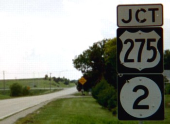
WEST End: IA 4/12, now J46 at US 275/IA 2, Fremont County
Save for the extension into Riverton, 42 was unchanged for its sixty years. Because it remained on the 1981 map, I have a page on the main site for this route. (6/16/03)
EAST End: Riverton, Fremont County
The final end of IA 42 was J64/K Street at Summer Avenue. Riverton (1920 pop. 568, 2010 pop. 304) lost nearly half its people over a century.
Page created 3/4/20