
(July 1, 1920-June 23, 1958)
- They knew it as: A road connecting Griswold to a main east-west highway, and then a road connecting Griswold to a main north-south highway
- We know it as: The northernmost part of IA 48, and then IA 92 between Griswold and US 71
- Let's get granular: See above. Eventually, this route would lead to one of the shortest-lived highways in Iowa history.
NORTH End: IA 2/IA 24, now IA 48 at Newton Rd., Cass County
In the first major change to an existing route in the Iowa highway
system, in January 1921 the Cass County supervisors asked the Iowa
Highway Commission to provide an east-west connection to Griswold at
the cost of not only the north-south route but also five miles of IA
24 through Lewis. This change was made not too long after, because the
supervisors met May 23, 1921, to approve a contract for a bridge "on
Primary Road No. 100" on the east-west road.
What the supervisors probably didn't know is that they had just gotten
themselves involved in a road war between Griswold and Oakland.
Facing west
© Iowa Department of Transportation. All rights reserved.
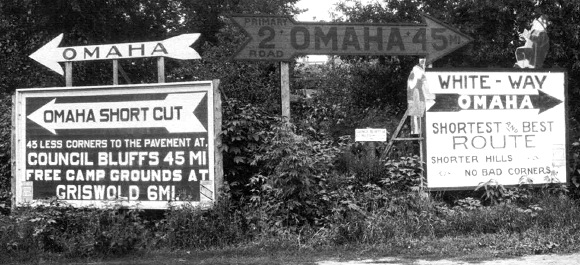
"The weeds in front of the big sign which directs tourists to travel over the short cut which leads to Griswold and the I O A Short Line, were cut Saturday and a large arrow placed on top of the sign. Don't be afraid to tell people that they will find a perfect road from Griswold to Council Bluffs via the I O A Short Line." — Griswold American, July 14, 1921
In the western half of Iowa, the Great White Way/White Pole Road became IA 2 and later US 32, the main route between Des Moines and Council Bluffs via Adel, Atlantic, and Oakland. In the summer of 1921, Lewis residents got very concerned that the White Way would be taken away from them and instead routed south of Atlantic (on present US 71) and west on the I.O.A. Short Line (present IA 92). On August 21, the Cass supervisors asked that the road east of Lewis be restored (Griswold American, September 1). While not part of the White Way, it may have brought peace of mind in that Lewis would not be dropped out of the system. The official 1914 county map shows this segment as "Added 10-10-21", yet the extension to Lewis as a state highway did NOT reappear until the 1929 map, and the 1925 Service Bulletin explicitly says IA 24 ends at US 71. I do not have an answer for this discrepancy.
The 1930 paving of US 32 straightened the White Pole Road from a mile west of the Pottawattamie/Cass line to just northeast of Lewis. That means this sign photo is ¾ mile south of 48's north end, at an extinct map dot called Iranistan. It was what one would see on westbound Nishna Valley Road at present IA 48. (IA 2 turned west again a short distance to the north at Newton Road.) The photo's likely date is between July 1921, when the large arrow was added to the left sign as noted in the news excerpt above, and September 1922, when the IHC temporarily swapped the routes of #2 and #7 west of Des Moines.
SOUTH End/WEST End: Griswold, Cass County
Facing west on 100 (post-1921 version), now heading west on 92 (10/22/14)
The intersection of IA 48 and IA 92 in Griswold (1920 pop. 1264, 2010 pop. 1036) is not likely where either version of IA 100 ended. Once highways were signed in town, it would have gone a few more blocks west into downtown.
EAST End: IA 18, now G53 at Lyman St., Cass County
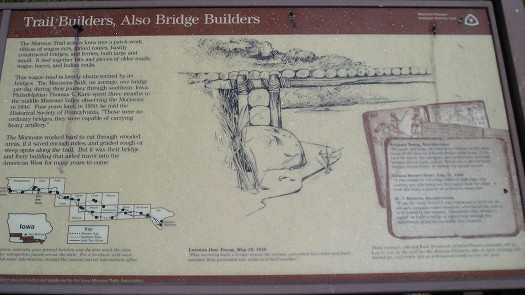
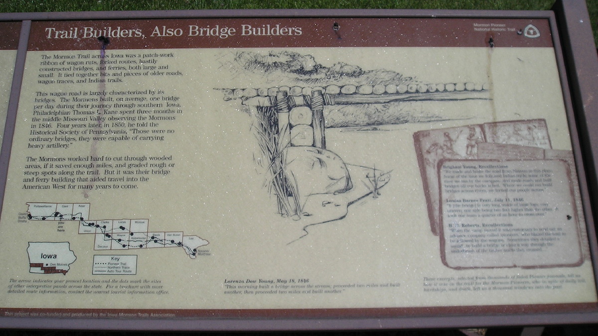
A larger version of this interpretive panel, legible on the left side (the right less so), can be found here. (6/27/06)
In the early 1970s, all of US 71 south of Atlantic was closed at some point for construction. In addition to the Clarinda bypass, mini-bypasses were created at Villisca, Grant, and Lyman, each moving the road just a shade west for a mile or two. Thus, the 1920 end is about 500 feet east of the equivalent modern junction, eastbound IA 92 at the south junction with US 71.
While the IOA Short Line was a popular auto trail, the road from Griswold west to Council Bluffs did not get into the state highway books until 1936. The most likely explanation is that although it was a nice, straight road, it only passed by one town (Treynor) that was not otherwise already on the state system.
IA 100 was paved in the 1950s. At the same time the route west of Griswold was paved, the last part of US 59 was also paved. Those two routes then intersected in a quasi-interchange that I believe is Iowa's second-oldest grade separation between two primary routes, behind US 30 at the Niland corner in Colo and just ahead of the Combination Bridge in Sioux City.
After 100 was paved, IA 92, which until then joined US 6 at Lewis and was redundantly multiplexed to Council Bluffs, replaced it. A new IA 100 was assigned to the 6-mile orphaned road from Lewis to US 71. It lasted five weeks.
"The changing of the number of these two highways, so adjacent to each other, caused much confusion. The Highway Commission has announced the road at Lewis to Fletcher Chapel will now be changed to Iowa No. 414." — Griswold American, July 23, 1958
Page created 3/24/20; last updated 10/23/20