
(July 1, 1920-October 16, 1926)
- In 1920, they knew it as: The Jefferson Highway, the "Pine to Palm" route running from Winnipeg to New Orleans, registered March 23, 1917 (9 counties); a continuation of MN 1, a number that later became US 65 north to Fairbault, MN 3 from Faribault to St. Paul, and US 61 from St. Paul to Canada.
- The Jefferson Highway was Iowa's first major north-south route to be completely paved, in 1930. Multiple others reached that status over the next four years.
- As one of two single-digit north-south routes, 1 intersected 3 (Leon), 8 (Osceola), 2 (Des Moines), 7 (Des Moines), 6 (Ames to Colo), 5 (Iowa Falls), and 9 (Manly).
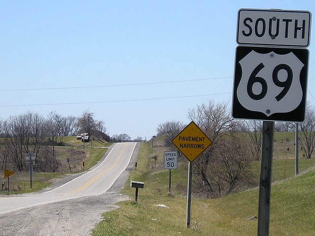
- We know it as: US 69 south of Ames, US 30/E41 between Ames and Colo, and US 65 from Colo north
- See also: Jason Hancock's Highways of Des Moines
- Let's get granular:
- State line to Osceola: US 69, 290th Street (partially dirt), J66, Teale Street in Davis City, Clark Street, US 69, short vacated segment east of present 69 then paralleling CB&Q, 275th Street, McIntosh Road (partially dirt), Old 69 Highway, US 69, 220th Street, Main and 10th streets in Leon, US 69, 250th Avenue (dirt), Popcorn Road, US 69
- Iowa and Missouri trade off jurisdiction of the east-west segment on the state line at the halfway point, following the deal made on June 18, 1928. Lamoni-to-Leon was paved in 1928-29. Missouri would finish paving US 69 in 1931, completing a paved road to Kansas City.
- A pony truss bridge from 1918 just north of 255th Street was closed in 2016, making the signed Jefferson Highway (as of mid-2023) noncontinuous.
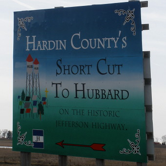
- Heritage Byway signage on Main Street in Leon explains the one-block offset between Main and present US 69 on Church Street, but... see "Along the route" below for further discussion.
- The 250th/Popcorn route, quasi-signed as a Jefferson Highway loop, was left behind in 1924.
- Osecola to Medora: US 69 with the following stairsteps: Leisure Drive, 230th Avenue, half-mile of 240th Avenue/R45, Miami Street (and vacated extension west), 250th Avenue, Norman Street, 255th Avenue, Liberty Highway, Scott Street, abandoned road through Hickory Hills County Park, extension of 108th Avenue north of creek
- The present route, eliminating 18 corners and five railroad crossings, was built in 1925.
- Medora is at the corner of US 69 and G76; an abandoned general store is there today, along with some houses.
- Warren County: G76, 120th Avenue, Pershing Street, 130th Avenue (and vacated extension along section line to near McGregor Street), US 65/69, northbound lanes north of Indianola, Fulton Street, 133rd Avenue, Summerset Road, 138th Avenue, US 65/69 (mix of northbound and southbound lanes)
- By the end of 1922, the road had been shifted to the current route from the 65/69 split down to G76.
- The route between the 65/69 split and Indianola, paved in 1928, was straightened in two phases. The piece of 130th Avenue double-dead-ending from Nevada Street was left behind in 1968, with the old road to the split removed. A now-driveway with a continuation abandoned in the 1990s, which Google Maps still calls Jefferson Way, running into McGregor Street with continuation across the South River on the other side of the sewage pond, was bypassed in 1948.
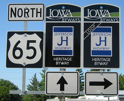
- US 65/69 through Indianola is Jefferson Way. The Jefferson Highway Heritage Byway is signed past both the courthouse square and the former high school. This route was straightened about when IA 1 came through. The 1921 Blue Book goes straight through on Jefferson Way.
- 138th Street now dead-ends south of the Middle River, and no trace remains of the segment through what was Banner Mine State Wildlife Management Area but on October 7, 2004, became Summerset State Park.
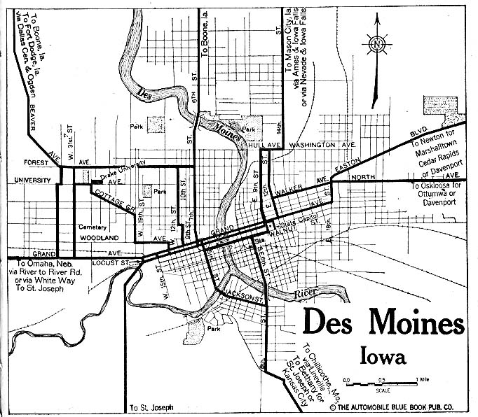
- Des Moines: Indianola Avenue, Indianola Road, 7th Street, Grand Avenue, US 69/East 14th Street
- Lyell D. Henry's Jefferson Highway book says Indianola Avenue was paved in 1920; the state map indicates 1921. Either way, it was removed from the route shown in a 1919 Des Moines map that used East 6th Street, Grand Avenue, East 12th Street, University Avenue, East 13th Street, and Washington Avenue between Indianola and East 14th.
- Indianola Avenue flowed into Indianola Road in Des Moines' Italian neighborhood until the early 2000s. A new bridge was built across the Raccoon River in relation to the Martin Luther King Jr. Parkway project, and Indianola Avenue was reconfigured/extended to meet it.
- The 1920 system put IA 1, 2, 7, 15, and 17 on Grand Avenue; more on that below.
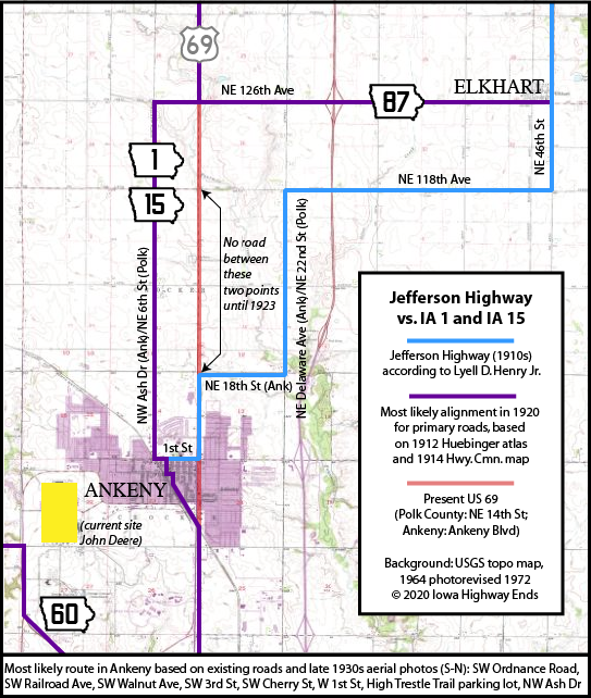
- Ankeny: Ankeny Boulevard (same as NE 14th St), SW Ordnance Road, SW Railroad Avenue, SW Walnut Avenue, SW 3rd Street, SW Cherry Street, West 1st Street, High Trestle Trail parking lot, NW Ash Drive
- Henry has a different routing between Ankeny and Elkhart, and every state map of the time shows a straight line, but this route matches the Huebinger 1912 county map. The 1914 county map and a 1921 construction document clearly indicate that part of US 69 north of what is now NE 18th Street did not exist until the early 1920s. See map down page.
- As late as 1960, nearly the entire town of Ankeny was contained in an area bounded by 1st Street, State Street, Ordnance Road, and US 69. Downtown was the block of 3rd between Walnut and Cherry.
- Yes, a parking lot. Satellite photos clearly show part of the lot near the water tower is an old street; this was changed in the 1990s. This lot was completely redone in 2022.
- Ankeny to Colo: NE 6th Street, NE 126th Avenue, US 69; 1st Street, Main Avenue, 5th Street, and 5th Avenue (dead end) in Huxley; US 69, Lincoln Way, E41
- The original route stuck to the half-section line and passed Lincoln Cemetery on the west side. Today's gentle angles around are all that’s left of the Des Moines-Fort Dodge interurban line and the extinct map dot of Midvale.
- Colo to Hubbard: US 65, D65, JJ Avenue, Wisconsin Street in Hubbard, 270th Street
- This is how the Heritage Byway is signed, but both Henry and I think that at some point the route moved to Maple Street instead of 270th between Wisconsin Street and S33, because this would take the route down Hubbard's business district.
- The 1921 Blue Book in Hubbard uses Elm, Michigan, and Maple, which sends the route to the back side of the school, the four-corners in the business district, and an eastbound exit.
- Hubbard to Iowa Falls, 1920-22: S33, K Avenue, 220th Street, KK Avenue (now broken by US 20), River Street, Washington Avenue, Talbott Street, Rocksylvania Avenue
- Iowa Falls segment is related to the Hawkeye Highway, which originally entered Iowa Falls from the northwest and came down Main Street, changed in 1917.
- Maps in the Blue Books use Fremont instead of Talbott. The 1921 Blue Book uses neither, routing the Jefferson Highway on Main Street and Rocksylvania Avenue instead, past the city park.
- Hubbard to Iowa Falls, 1922-26: S33, K Avenue, D41, US 65 (with a slightly different RRX), Rocksylvania Avenue
- This segment was the last part of US 65 to be paved. The South Fork of the Iowa River varies the land's topography in the area, hence the original route and the original IA 134 (mostly 245th Street) as a connection between Hubbard and Eldora.
- Iowa Falls to Minnesota: D15, S45, US 65, IA 3, 1st Street NW in Hampton, C33/12th Avenue NW, S43, C13/Gilman Street in Sheffield, US 65, B65, Pheasant Avenue/1st Street in Rockwell, 170th Street, US 65, Federal Avenue (downtown Mason City, now broken by Southbridge Mall), US 65 (southbound lanes/Orchid Avenue), 310th Street, Pheasant Avenue, 340th Street, Partridge Avenue, 400th Street, Main-5th-Elm-6th streets in Kensett, US 65, 480th Street, Nightingale Avenue, 490th Street, Mockingbird Avenue and vacated extension north to state line
- The road through Rockwell was paved in 1921, and then US 65 was straightened in 1931 — a rare case of a paved road being bypassed before World War II. (The most prominent example is the Belle Plaine cutoff on the Lincoln Highway.)
- The road wasn't straightened in Worth County until it was paved in 1929. The 1929 paving document includes a wacky jaunt into downtown Manly using IA 9, Broadway Street, and Harris Street, and crossing the railroad twice. It looks like the obvious straight-line route was included in a revision. The corner of Broadway and Harris was the site of the original Manly school; the gym built in the 1950s still stands. The intersection with IA 9 had a diamond of connectors around it; to get a feel of where those curves were, the southeast one would've gone right past the front door of the Casey's there today.
NORTH End: Minnesota state line, now near US 65, Worth County IA
Photo by Monte Castleman
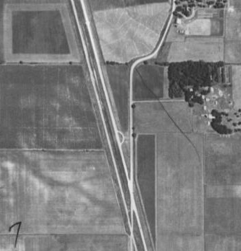
USDA/NRCS (1938)
The north-south line is Mockingbird Avenue, now broken across the diagonal railroad (left) and US 65 (right). This shows 1 at the state line.
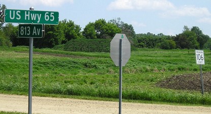
Facing east-southeast from state line (5/28/06)
This is looking in the direction of where IA 1 would have exited the state, on the section line, which is now a driveway. North of the state line, the Jefferson followed 813th Avenue, 110th Street, 810th Avenue, and 150th Street on the way to Glenville.
Along the route
Facing north on 65 (7/16/20)
The non-straight Jefferson Highway between Manly and Kensett is marked as a loop. Here, at the intersection of Main and 6th in Kensett near downtown, is where they split/meet.
This sign at the intersection of present 65 and S33 promotes both the Jefferson Highway and Hubbard's "hot and cold running water towers". However, the towers were removed in 2011. (3/26/10)
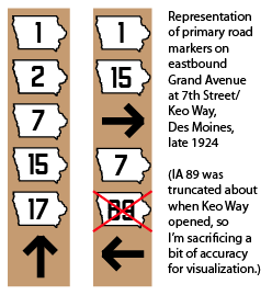
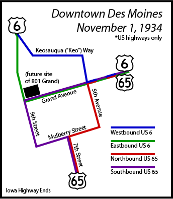
These images, one a mockup and the other based on research into Highway Commission minutes, are intended to show the early highway systems in Des Moines. The 1925 state map, the first with insets, clarified a lot about downtown (except, perhaps, the pre-Keo routing of IA 7). Later, left turns at 7th and Grand were banned, and by mid-1932 we had the situation seen at right. IA 1 is US 65 and IA 2 is US 6, which brings up one very notable trait of the 1920 system: Primary #1 and Primary #2 met in downtown Des Moines. That, in turn, brings up another tidbit. From 1919 until 2013, if you walked around the corner to 8th and Locust...
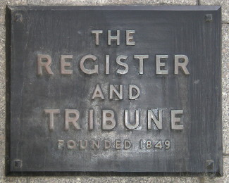
...you passed by the headquarters of the Des Moines Register and Tribune. IA 1 and IA 2 overlapped on Grand Avenue east to the State Capitol, symbolically converging in the heart of the state. (6/11/13)
Tourist
travel is heavy - Large number of autoists pass through city over
Jefferson.
["]Travel over the Jefferson Highway this season promises to be heavier
than ever before," says E.G. Bants, secretary for Iowa of the Jefferson
Highway Association. Tourists in greater numbers than ever before at
this time of year are passing over the road, many of whom are stopping
in Osceola's tourist camp. The travellers state that the road is the
best they have ever ridden over and their good word with the extensive
advertising the Association is doing is making this road one of the best
known in the country. It has within the span of a few years grown from a
mere marked trail across the continent to a great international story of
travel, known all over the world as one of the best.
— Osceola Sentinel, June 7,
1923
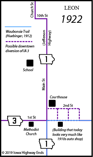
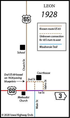
The 1928 paving plan from the Missouri line to Leon, which at that time was the entire route of US 69 in Iowa, has a surprise: It puts US 65 on 2nd Street instead of 1st in downtown Leon, which would have taken 65 past the courthouse instead of a block south. This would mean US 69's first end was a block north of the present US 69/IA 2 intersection, whose position is unambiguous since both the church and library are still there. But I have found no other document that shows this, nor do I know which street 65 would have used to go a block south to head east like IA 2 does today. Huebinger's Map and Guide for Waubonsie Trail (1912) shows the road leaving Leon on 1st Street, like IA 2 today.
SOUTH End: Missouri state line, Decatur County IA/Harrison County MO
Facing west, but heading south, on 1 (4/16/07)
Just a few miles north of here, downtown Lamoni retained brick pavement
until the 21st century. About a mile and a half behind the camera (east)
is where the road into Iowa turns north, right beside I-35, an
interstate that does for Iowa today what the Jefferson Highway did in
1920.
Page created 5/9/20; last updated 5/29/23