(July 1, 1920-February 1, 1939)
- In 1920, they knew it as: The Great White Way, registered July 30, 1914. "This route from Davenport to Council Bluffs totaling 340 miles was the first route to get a certificate from the Highway Commission." The key route between Des Moines and Council Bluffs. (14 counties)
- From Oskaloosa to Davenport it overlapped with the I.O.A. Short Line, which followed present IA 92 across the state.
- The below will not count the 7½-month swap with IA 7 in the western half of the state in 1922-23, although that's the route that would become US 6 in late 1926
- We know it as: US 6 (pre-interstate move) from Council Bluffs to Des Moines, IA 163 from Des Moines to Oskaloosa, IA 92 from Oskaloosa to Muscatine, and US 61 from Muscatine to Davenport
- Let's get granular:
- Council Bluffs: Broadway, Oak Street (now a pedestrian walkway), Pierce Street, McPherson Street, G60 (broken by the Council Bluffs Airport), US 6
- Oakland: Frank Kearney Road, Chautauqua Avenue, Oakland Avenue, Main Street and abandoned extension northeast
- Oakland to Atlantic: US 6, 525th Street, Hitchcock Avenue, Newton Road, vacated diagonal through Iranistan Quarry (1920-21 only)/IA 48, Nishna Valley Road, Webster and Main streets in Lewis, 582nd Street, vacated road, 585th Street, Jasper Road, Nishna Street, 29th Street, Sunnyside Lane
- The segment northeast of Lewis was diagonalized to present US 6 in 1921.
- Atlantic to Adel: US 6, 635th Street, Hamburg Road, 655th Street, Hampton Road, vacated curve, Hamburg Road, Prospect Street in Wiota, IA 83, Main Street in the southwest part of Anita, IA 83, IA 148, G30, 760th Street, Chicago Road (and vacated extension west), Afton Avenue, 110th Street, G30, N54, F65, 340th Street, IA 25, F65, 345th Trail, vacated road south of railroad, Victory Trail, vacated extension of 350th Street, Dexfield Way, Maple Street, P48, Bear Creek Road, El Paso Way, F60, 1st Street through Redfield, River to River Road/302nd Street, F60 with corner at L Avenue, F60
- All of this is future US 32/US 6, in parts moved onto I-80 in 1980 and 2003.
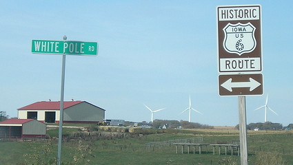
- The Adair-Dexter segment (former IA 925) is also known as the White Pole Road, revived for tourism in the 21st century.
- The route was changed to follow the railroad through Casey in 1921. "This will eliminate a lot of bad hills north of Casey[.]" (Griswold American, July 21) Huebinger's 1912 map of Guthrie County marked the White Way following the railroad west of Casey, then McPherson Street (downtown), Grant Street, 348th Street, Maple Avenue, and 340th Street.
- Adel: Alley north of Van Fossen Lane; Brickyard Drive; Main, 6th, Prairie, 5th, and River streets; abandoned but extant bridge over Raccoon River
- Redfield to Des Moines overlaps the 1910 River-to-River Road.
- Adel renamed its north-south streets sometime during the 20th century.
- Construction ca. 1922 adds a diagonal extension of F60 to 18th Street, then north to Main, picking up existing pavement at "School Street." The continued existence of the ca. 1916 Adel school building is a clue that School is probably 11th Street, and decorative brick pavement on Main Street starts there today.
- Adel to present IA 28: 288th Trail, US 6 (westbound lanes), Ashworth Drive, 2nd Street, road behind the houses on Northview Drive, L.A. Grant Parkway, roads approximately corresponding to Tallgrass Lane and Bluestem Drive, Ashworth Road
- The R2R used Warrior Lane, University Avenue, and 88th Street, but this had changed by 1922, according to construction documents that ironed out the segments on Ashworth and Grant to use the roads that are there today. The old parts weren't deleted from the county system until 1926. Growth of Waukee in the 21st century has resulted in the paving of Grant (formerly V Avenue).
- Rerouting away from University and 88th avoided two RRX's. Part of 88th Street was vacated ca. 2004. The section-line intersection of 88th and Ashworth is marked today by the northwest corner of a fill pond south of I-80.
- Ashworth-Grant (V Avenue)-Ashworth was exclusively US 32, 1926-31. The corner of Grant and Ashworth was often referred to as the "Grand Forks Corner" (Images of America: Waukee, p.43). The original White Pole Road split from the R2R here, continuing west on Ashworth to its end, then following T Avenue, 332nd Road, S Avenue, 340th Trail, and R16 to Van Meter, then going west to Dexter.
- In late 1930-early 1931, the Highway Commission planned a reroute of US 32 that would have kept the highway on Ashworth Road and a western extension all the way to US 169, meeting it at the intersection of Old Portland Road and 330th Lane. This outraged pretty much everyone in Dallas County, to the point a lawsuit was filed. By the end of April, the IHC had backed down, and announced the highway instead would run out of Des Moines on Hickman Road, and southern Dallas County would get a consolation prize that became IA 90. (Perry Daily Chief, Nov. 22, Feb. 9, April 28)
- A scrap of abandoned pavement between Ashworth Road and Grand Avenue remained until 2021 as the edge of the parking lot for Val Lanes Recreation Center. There was no north-south bridge over Walnut Creek until the 1960s!
- IA 2 and IA 17 overlapped between Adel and the intersection of Grand Avenue and East 30th Street, at the west gate of the Iowa State Fairgrounds.
- IA 28 to Prairie City: Grand Avenue, E 30th Street, IA 163/University Avenue, NE 12th Avenue (broken at US 65), IA 163 (westbound lanes), NE 12th Avenue between NE 88th and NE 92nd streets, IA 163, Poplar Avenue/old IA 163, S 76th Avenue W
- Prairie City: North Street, Main Street, 2nd Street, Plainsman Road
- Prairie City to Oskaloosa: Prairie Avenue/old IA 163, S 80th Avenue W, W 78th Street S, F62, W 70th Avenue S, S 104th Avenue W, Quail Avenue, North and Commerce streets in Monroe (broken by IA 163 four-lane), S 128th Avenue W/County Line Road, 140th Avenue, Briggs Street, a series of vacated roads bumping along the now-gone railroad tracks barely seen in 1930s photos but includes 152nd Place, old IA 163 through Otley, IA 163, old IA 163, Business IA 163 in Pella (Washington, Main, and Oskaloosa streets), IA 163, abandoned driveway and pavement west of 185th Street, IA 163 (including vacated segment southwest of current route between Elba Avenue and T43), old IA 163/IA 432
- The highway between Prairie City and the Marion/Mahaska county line, when paved, followed the Chicago, Rock Island & Pacific railroad, then a few miles east had a direct diagonal.
- Oskaloosa: Pella Avenue, L Street, High Avenue, 9th Street, IA 92/A Avenue
- High Avenue, a block south of present IA 92, is broken by William Penn Mall. The shift appears to have been in the 1930s.
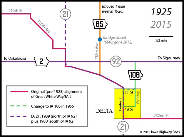
- Oskaloosa to Washington: IA 92, 248th Street, Snyder Avenue, IA 92, Teller Avenue, 230th Circle, Washington Street in Rose Hill (and vacated westward extension), 230th Street, Yarnell Avenue, vacated road across North Skunk River that runs into long field driveway, 210th Street, 125th Avenue, IA 21, 232nd Street, 163rd Avenue, 230th Street, 200th Avenue, Delta Road, Pleasant Valley Street, IA 149, IA 92, 280th Avenue, 210th Street, V67, Main and Hutchinson streets in Harper, G32, 330th Avenue, Broadway Avenue in Keota, V15, 210th Street, Fir Avenue, G38
- The abandoned concrete northeast of Royal Avenue is part of a 1930 alignment. Ditto the concrete connection between 230th and 92 (old RRX). There's an older angled vacation just north of 230th at its east end.
- But not the portion of old IA 426 east of Rose Hill (also 1930 paving).
- What about that road named Old Highway on Delta's east side? I'm going to say, probably not, as it would miss downtown. But see the map farther down page.
- Washington to Ainsworth: IA 92, Avenue D, Washington Boulevard, IA 92, 247th Street, Palm Avenue, 250th Street, IA 92, G6W (¼ mile) and vacated driveway to east, IA 92
- My speculation on Washington was confirmed by a 1938 story in the Washington Democrat-Independent. Here's my rationale: The original route wouldn't have missed the town square. The former gas station at the corner of Madison Street (present 92) and D is another supporting piece, since turns are a good place for those. Finally, blueprints for expanding Madison in 1957 show D was concrete while the other streets that intersect 92 were only blacktopped.
- The abandoned pavement near the G6W junction is from a curve that was lengthened in 1956.
- Ainsworth area (1?): Railroad Street, 1st Street, 250th Street
- It's unlikely the 1920 route bent with the railroad, but the earliest documentation I can find is 1927, by which time it did.
- Ainsworth area (2?): IA 92, abandoned/vacated road closer to railroad tracks at US 218 interchange
- The gravel road named Old White Way today is not the route of IA 2, which went through Ainsworth and Cotter from the beginning. However, it is the route of the original Great White Way and overlapping I.O.A. Short Line auto trails, which rejoined IA 2 at Columbus Junction.
- US 218 to Columbus Junction: IA 92, Main Street in Cotter (dead-ends now, resulted in double RRX), W66, 150th Street, 145th Street, U Avenue, IA 92
- Columbus Junction to Fredonia: Western Access Road, Walnut Street, now-gone bridge on south side of railroad, Concord Street, Main Street, 214th Avenue, unnamed corner
- This is the "Convict Road" of 1914, one of the two oldest surviving segments of concrete in Iowa used on a primary highway.
- Fredonia to Muscatine: IA 92, pieces of old US 61 up to 170th Street, US 61
- Starting at Grandview, IA 2 overlapped with IA 20 (future US 61).
- North of the Letts corner (former IA 305), the four-lane hews pretty close to the original, with the exception of a squared-off corner at 275th Street and the left-behind frontage roads now named Fruitland Road and Grandview Avenue.
- Muscatine: Present Business US 61: Grandview Avenue, Green Street, Hershey Avenue, Mississippi Drive (formerly Front Street), Mulberry Street, 2nd Street, Park Avenue
- Muscatine's Main Street is both short and in an odd place (near that "notch" in the highway route). Was that a different settlement at first?
- The position of the northbound sign gantry on IA 38 at US 61, at Taco Bell, is where 20 and 38 split.
- Muscatine to west Davenport: US 61, frontage road between New Era Road and 180th Street, Y14, 172nd Street, US 61, 170th Street, US 61, 160th Street (and southwest extension to Tucker Avenue), Martz Lane, US 61, Y26, 150th Street, Oak Lane, Mayne Street and Burnside Lane (dead end) in Blue Grass, US 61, 140th Street Place just west of I-280, Business US 61, a bit of Blue Grass Road northwest of IA 22 exit and Walnut Creek, Ricker Hill Road
- Oak Lane before being realigned for the US 61 exit, straight north from the gas station to Telegraph Road.
- Blue Grass Road, as in the road to Blue Grass, now reduced to a short neglected dead end.
- Davenport: As researched by Jason Hancock and on the 1925 state map: Rockingham Road, Clark Street, Telegraph Road, 3rd Street, Pine Street, 4th Street, Perry Street, 2nd Street, Government Bridge
- Huebinger's Map and Guide for River to River Road (1910) used Howell, 3rd, Main, and 2nd streets between Rockingham Road and the bridge.
- Related routes:
- US 63/US 163/IA 163, between Des Moines and Oskaloosa
- IA 925, old US 6 from Adair to near Dexter. This was one of the few 900s to be signed; the rest listed below were not.
- IA 335 (II) in Otley, IA 374 (II) in Monroe, and IA 392 (II) in Prairie City, all left behind when IA 163 was four-laned in the late 1990s
- And, very weirdly, halfway between Pella and Oskaloosa, a 700-foot segment for one house that was bypassed in 1999 but given a designation of IA 903 in 2011 and as far as can be seen remains on the books.
- IA 968 (II), Business IA 163 through Pella
- IA 373 (II), two segments of US 61/IA 92 between the Louisa/Muscatine county line and the southwest part of Muscatine left behind when 61 was four-laned
- IA 421, two segments of US 61 between New Era Road and 180th Street northeast of Muscatine and also old US 61 through Blue Grass
- "421" was skipped by the Highway Commission in the early 1960s for unknown reasons. IA 422, 424, 426, and 428 were all assigned and signed.
- IA 432 (II), old IA 163 on the west side of Oskaloosa
- IA 936, short nearly-abandoned segment in what is now the northwest corner of the IA 92/old US 218 intersection near Ainsworth. It was mainline 92 until a straighter segment was built so the new interchange wasn't right at the railroad.
- IA 964, post-paved pre-1970s IA 92 from old IA 2 to the Marion/Mahaska county line
- IA 973 (II), old US 6 and later IA 83 between US 71 and IA 148
- IA 973 (III), old IA 92 through Winterset
- See also: Council Bluffs Highway Chronology, Jason Hancock's Highways of Des Moines, Muscatine Highway Chronology, Jason Hancock's Highways of Davenport and Bettendorf
WEST End: Missouri River (Ak-Sar-Ben
Bridge), Council Bluffs IA/Omaha NE,
Pottawattamie County IA/Douglas County NE
Library of Congress photo (1938)
Along the route
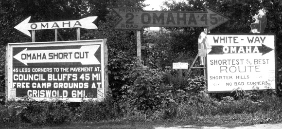
Facing west
© Iowa Department of Transportation. All rights reserved.
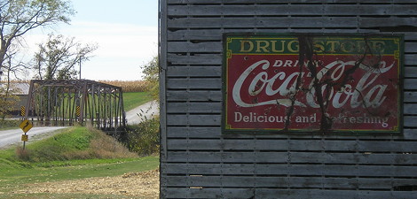
The 1930 paving of US 32 straightened the White Pole Road from a mile west of the Pottawattamie/Cass line to just northeast of Lewis. That means this sign photo is ¾ mile south of 48's north end, at an extinct map dot called Iranistan. It was what one would see on westbound Nishna Valley Road at present IA 48. (IA 2 turned west again a short distance to the north at Newton Road.) The photo's likely date is between July 1921 and September 1922, when the IHC temporarily swapped the routes of #2 and #7 west of Des Moines until May 1923.