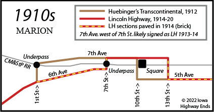
The journey to figure out the Lincoln Highway in Marion starts with something that happened much later: The present-day route of Business 151 entering the city from the west is not what it was in the first half of the 20th century. Between Blairs Ferry Road and Second Street, the road was straight north-south on First Street, with corners at Sixth and Seventh avenues plus a railroad underpass. "It is a much needed improvement," the Marion Register said March 10, 1907, "and one that will be appreciated as there is a very sharp turn in the street at that place and seems like a miracle that a number of accidents have not occurred there."
It was this underpass, and Seventh Avenue to the east, that was included in Huebinger's Map and Guide for Iowa Official Transcontinental Route, published in 1912. The following short article seems to affirm Huebinger's route being used for the Lincoln Highway, at least initially:
Marking highway.
The Marion commercial club has commenced marking the route of the Lincoln
highway through the city and workmen have painted the white stripes on the
electric light poles from Twogoods' hill, along the boulevard and Seventh
avenue, through the business district, then east on Fifth avenue as far as
Twenty-seventh street. The red and blue stripes and the "L" will be
painted on next, and for a distance in the county southeast of town, metal
signs on metal posts driven in the ground will be used.
— Cedar Rapids Evening Gazette, June 24, 1914 [Twogoods' Hill is
southwest of Thomas Park.]
But the macadam road from 1904 on Seventh Avenue was not faring well in the public eye:
The proposition of paving 7th avenue and the
streets in the business district, which were paved a few years ago with
alleged asphalt, was brought up again. ... It is the main thoroughfare
through the city and is known by everyone who drives through town as one
of the worst strips of road for many miles, for the alleged asphalt paving
is full of holes and the rest of the avenue is very rough. So the council
decided it best to pave this year, while the base under the asphalt
pavement is still good and can be used. This new contract will call for
paving or resurfacing ... Seventh avenue from First to 13th streets.
— Marion Weekly Sentinel, July 23, 1914
The Marion Register reported on December 5, 1913, that the city council had approved about 40 blocks of street paving to go with the 80 that already existed in the core of town. Included in this list was Sixth Avenue between Seventh and First streets, but not Seventh in the same area. That paving was completed in August 1914, the Register reported on September 1. But paving on Seventh repeatedly ran into complications. On August 20, 1914, the Sentinel said recent bids on the work were too high, and I can't find any follow-ups.
It seems that Seventh did not get any new paving until a decade later. In August 1924, property owners were so despondent over the condition of the road they "requested steps be taken to spread gravel over the old macadam" (Sentinel, August 7). After a contract was let, the Sentinel on October 9 said, "This will make one of the finest thoroughfares in the city when the improvement is completed and will relieve the heavy traffic which now passes over Sixth avenue." The "Warren bitulithic paving" on the existing macadam base (referenced in the Sentinel on October 23) was completed by the end of the year.
I believe that while the Lincoln may have used Seventh Avenue west of Seventh Street for its first year, by the end of 1914 the route was switched to Sixth Avenue to take advantage of the brand new brick pavement there.
It does not appear 10th Street was included in the Lincoln route, likely because using 13th added a few more blocks through the business district. On October 20, 1914, the Register's story about dedication of a soldiers' monument specifically mentioned "the northeast corner of the city park facing Seventh avenue, the Lincoln highway." The Civil War monument remains in place today, although the figure on top was beheaded in the 2020 derecho and required repair. In mid-1918, a gas station that became known as the Lincoln Highway Garage opened at the southeast corner of Seventh Avenue and 13th Street. As kind of shown in the entry below, guidebooks of the time were map-less, relying on painted poles to guide travelers.
Marion. (N.Y. 1125 miles, S.F. 2206
miles.)
Three hotels, 2 garages. Local speed limit 15 miles per hour, enforced.
Route marked through city and county, signs at city limits. Extensive road
improvement completed in 1915 and more planned for 1916. One railroad
crossing at grade. Three banks, 1 railroad, 60 general business places, 1
express company, 1 telephone company, 2 newspapers, 4 public schools,
electric lights, trolley and water works. Commercial Club. L.H. Local
Consul, Edw. J. Otterbein.
— The Complete Official Road Guide of the Lincoln Highway, Second
Edition (1916)
When did the Lincoln Highway here switch from Sixth to Seventh? I discovered an alignment change in 1920 — but not in the direction I expected.
Lincoln Highway still here
Marion will remain a part of route, official markers placed
Marion citizens are much pleased when they see the official
Lincoln Highway markers, which were placed here last week. Marion was
supposed to have been taken off the routing of the highway when the paving
of the cut-off was settled diverting the travel from Mt. Vernon direct to
Cedar Rapids. ...
The highway markers are placed on Fifth avenue, from the east edge of
town, as far as Seventh street, then on to Sixth avenue leading west to
the boulevard. The old route included a part of Seventh avenue from
Seventh to Thirteenth street, but this added three blocks to the distance.
— Marion Weekly Sentinel, October 28, 1920
The description in the Sentinel, and the Evening Gazette two days earlier, confirms the extent of the Seventh Avenue segment on the previous alignment but also puts the Lincoln Highway on a routing that appears to have been completely overlooked until, well, this webpage. (Hardest hit: The Lincoln Highway Garage, which wasn't on it anymore. It appears around 1933 it became known as Dickey's Standard Service. In December 1941, "the oldest service station building in Marion" was replaced with a new building, and the station or remnant of one remained until the mid-2010s.) I must point out that nearly every map and atlas of the time did not show highways inside city limits, perhaps because the Highway Commission wasn't truly in charge of them until 1927, so absolutes are hard to come by.
This routing was short-lived, at least officially. The Mount Vernon "cut-off" paving east of Cedar Rapids opened to traffic October 1, 1921, and anyone beside local travelers gravitated toward that route. The national association ratified the change no later than 1924, and the rest of the Lincoln Highway in Linn County was paved by the end of 1925.
Losing the mainline Lincoln Highway was the second of two blows to Marion's prestige in a short time. In a countywide vote in 1919, Cedar Rapids was able to wrest the county seat away. It was the last such switch in Iowa history. (The Evening Gazette on November 1 included a propaganda piece from the "Linn County Publicity Committee on Court House Removal" about the danger of the Marion courthouse burning down. It was illustrated by local art teacher Grant Wood.)
IA 94: Unloved and ignored
The Iowa Highway Commission's 1920 system did not include Marion in IA 6, which was to replace the Lincoln Highway across the state. Instead, IA 6 was along "the cut-off"/Mount Vernon Road, and the segment from Marion to Mount Vernon, later truncated to about the Seedling Mile, was designated IA 94. This number didn't gain much traction in the early press, which still usually called the road "Lincoln Highway". Little improvement was done to it, with the notable exception of a bridge/culvert project in 1926 that included the still-existing bridge on Big Bluestem Drive. By the time of its elimination in 1961, it was Linn County's only state-maintained road that had not been paved.
In July 1920, when the numbers of the primary system were painted on poles across the state, the Lincoln was using 13th Street to intersect Seventh Avenue. Since the reroute that omitted Seventh was changed that October, and IA 28 was still on Seventh through downtown, it's probable the primary designations stayed where they were. We know for sure that 94 was using 13th no later than 1936.
What about the east side?
Lincoln Highway researcher Gregory Franzwa, in 1995, had this route heading east to Munier Road: Fifth Avenue, 27th Street, Fourth Avenue, 31st Street, Third Avenue, 35th Street. This has two problems: There is no evidence of Third Avenue existing east of 31st Street until much later, and there's no evidence of Fourth Avenue existing between 27th and 31st streets until much later. To be sure, Franzwa had access to material I do not, but I have access to material he did not.
Huebinger had 27th Street and Third Avenue west of 31st, and this appears to have been the original route. Although the article below refers to 30th Street, aerial photos from 1936 make it clear it means today's 31st. I have more confidence that this change also would have applied to IA 94 than I do the one closer to the city center.
Change the Lincoln Highway in Marion
One turn is cut out and traffic will be routed over a better drained
street
Marion city authorities have made an improvement in the Lincoln highway at
the southeast corner of town that should appeal to those who use it. The
road from Marion to Mt. Vernon has for years turned from Fifth avenue,
south at Twenty-seventh street, then east on Third avenue and then south
at Thirtieth street.
The plan is to route the traffic east on Fifth avenue to Thirtieth street,
then south out of town. This will eliminate one turn in the road and will
also route the traffic over three blocks that have good drainage ...
According to the old way of travel, the turn at Twenty-seventh and Fifth
was made over a brick crossing, which was usually hard on springs and
dispositions, but no such crossing will be met at Fifth and Thirtieth.
— Cedar Rapids Republican and Times, November 6, 1921
What about the road to Springville?
The first part of sussing out the original road to Springville and on to Dubuque is easy: Today's slope connecting Seventh Avenue to 10th Avenue between 31st and 35th streets didn't exist until it was paved in 1929. The city limits stopped at 31st Street, so the curve's absence is visible on county maps. But the simple assumption of following Seventh west of that turns out to be incorrect.
The city council has under consideration the
graveling of two of the leading highways leading [sic] out of the city
from the end of the brick paving to the city limits. One of these is the
improvement of the Springville road from the end of the paving on Eighth
avenue to the Rompf-Patterson corner and the other the graveling of the
Lincoln Highway from the end of the paving on Fifth avenue to the city
limits.
— Marion Weekly Sentinel, June 7, 1923
A committee composed of A.P. Munson and J.C.
Fulkerson was appointed to confer with the highway commission relative to
the relocation of No. 161 so that it will come into the city in
Twenty-second street to Seventh avenue instead of of turning west into
Eighth avenue. This would eliminate two bad turns in Eighth avenue at
Thirteenth street and in Thirteenth street at Seventh avenue.
— Cedar Rapids Evening Gazette and Republican, July 12, 1927
Between these two stories, it's clear that US 161 (aka IA 28, 1920-26) ran on Eighth Avenue east of downtown to the city limits. The change was at 13th Street, based on the second story, and that makes some sense as that's where the pre-1920 Lincoln Highway turned south from Seventh Avenue. I don't know if the switch to 22nd Street was made, but the paving in 1929 put the route on Seventh all the way to the new curve at 31st Street. (The use of "in" to describe the location rather than "on" or "at" is common in newspapers of the time.)
The final alignment changes
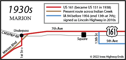
Council approves Seventh Ave. route
At the [Marion] city council meeting last evening, action was taken
favorable to the routing of the state primary highway, No. 161, along
Seventh avenue. This routing was brought to the attention of the city
dads, it was state, by the state highway commission, which is said to
prefer the Seventh avenue route the entire length [emphasis
added], the primary road to cut through the Sargent farm east of town. ...
The highway will be marked soon in accordance with the Seventh avenue
course.
— Cedar Rapids Evening Gazette and Republican, September 4, 1929
Paved US 161 opened between Marion and Springville in the first week of November 1929, based on Gazette articles. On December 5, the Highway Commission approved a "very small change" for 161 in Marion, removing from Seventh Street and Seventh Avenue and putting it on the Seventh Avenue/First Street route. However, this change missed being publicized:
Because the Highway Commission minutes mention the west-side all-Seventh alignment twice, once when changed in late 1929 and again in early 1936, it must be treated as gospel. (Minutes overrule maps.)
The final change to the highway on the west side of Marion was a prolonged two-step process.
The project to build a new bridge over Indian Creek and straighten the
renumbered US 151 was supposed to be done shortly after an overpass of the
railroad at Tama Street just to the south. Unfortunately, the Iowa Highway
Commission announced the plan on December 4, 1941.
The project still got let in January 1942, and the five-paragraph Gazette
story on January 29 said it would take three months "if priorities
permit." Priorities, it appears, did not permit, and the $113,050 contract
became a $157,405 contract 4 1/2 years later. The bridge opened in
September 1947, but the underpass — called "one of the most dangerous
L-shaped underpasses in the state" by the Sentinel in 1949 —
remained in use until a railroad bridge over a new four-lane road opened
just to its east in June 1960. This railroad overpass was demolished in
fall 2020 and replaced with a bridge
for the CeMar Trail.
Page created 6/7/22; last updated 6/17/22