(July 1, 1920-October 16, 1926)
- In 1920, they knew it as: The Marysville-Carroll Trail, registered December 6, 1919; if anything official predated that I have found no record. From Atlantic to Templeton it overlapped the Nishna Valley Route. (6 counties)
- We know it as: US 71, and IA 175/M54 in its northernmost part
- Let's get granular:
- Page County: US 71, 270th Street, Main and Hersey streets in Shambaugh, Rose Avenue, US 71, Business US 71 (Glenn Miller Avenue and Washington Street), T Avenue, vacated extension of 180th Avenue across the West Nodaway River, US 71
- The 1914 map does not show a road down the middle of Section 36 (Rose Avenue) at Shambaugh. Absolute confirmation of a "downtown" routing comes from 1923 construction documents, with "Present Primary Road #18 also M.C. Trail" intersecting a new road along the west city limits. Present 71 on the other side of Shambaugh was built in 1972.
- Villisca: U Avenue (old 71), 8th Street, 3rd Avenue, High Street, U Avenue and dead-end extension
- Villisca to Atlantic: H46, T Avenue, vacated extension of 185th Street across the West Nodaway again, US 71 excluding bypassed segments at Grant and Lyman
- "According to information received a few days ago ... the road extending through Villisca, Grant, Audubon and north to the Minnesota line is a part of the primary road system as laid out by the highway commission and will be improved under the recent primary road law in the near future. This road is known in Montgomery and Page counties as the B-Line road." — Red Oak Express, July 21, 1919
- Atlantic to Exira: US 6/IA 83, Olive Street, Great River Road, Dunbar Road, 645th Lane/Heron Avenue (same line, broken by I-80), 345th Street, Riverview Road, Jay Avenue, 310th Street, Kingbird Avenue
- This segment overlapped the River to River Road, one of Iowa's first auto trails. The R2R was very winding between Adel and Avoca and only parts of it were incorporated into the 1920 system.
- The only concrete on IA 18's route was a half-mile between the then-city limits of Atlantic and the present 6/71 junction. However, the entire route south of the Sac/Carroll county line, which became US 71, was paved by the end of 1931.
- This segment was moved to parallel the Chicago, Rock Island & Pacific Railroad in 1927, running through Brayton instead of the extinct map dot of Oakfield just east.
- Exira: Probably Westside Drive, South Street, Broadway Street, Washington Street, Center Street, and a vacated extension of 280th Street. Original 18 crossed the railroad between 280th and 270th to get back on present 71.
- Exira to Audubon: US 71 but with ½ mile of IA 44 through Hamlin in the middle, between a vacated extension southward on Kingbird Avenue and a vacated extension northward on Jay Place
- Audubon: 18 came in from the south on East Division Street for sure. But from there to rejoin present 71, there are two likely options:
- South Division Street — yes, there is an intersection of Division and Division, the streets on the section lines
- Leroy Street, Park Place, Tracy Street, and Broadway Street — a routing past the school, courthouse square, and downtown
- Audubon to Carroll: US 71, N18, 290th Street, Jade Avenue and 200th Street (1920-22)/US 71 (after 1922)
- Carroll: W 3rd, Main, 12th, West, and 30th/180th streets. This is semi-estimated, but comes in on the Lincoln Highway, uses most of Main Street, and passes by both the courthouse and the school (now Adams Elementary)
- Huebinger's Map and Guide for Iowa Official Transcontinental Route (1912), which became the basis for the Lincoln Highway, uses Main Street between 3rd and present US 30, not Carroll Street two blocks west as is prominently signed today.
- Carroll to Sac City: US 71, Xavier Avenue, 360th Street, Wadsley Avenue, D59, US 71, IA 175, M54
- The extinct map dot of Grant City, just across the Raccoon River on Xavier, is just a cemetery now; the "village" of Ulmer, to the west, remains on the state map by virtue of its elevator (still with rail access!)
- Sac City: Possibly Gishwiller, 11th, and Main streets. This would avoid a railroad crossing that going straight north on M54 would require, hit the school (and the second, 1936 school) at the corner of 11th and Main (now a community center), and go a bit east to end at the business district/courthouse.
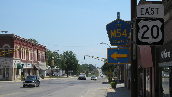
NORTH End: IA 23, now D36/Main St. at 5th St., Sac City, Sac County

Facing east on what was certainly IA 23, and possibly IA 18 (7/22/12)
Based on conventions of the time, there were probably a few blocks on Main Street that Sac City wanted as both 18 and 23.
The opening of four-lane US 20 2½ miles north of here a few months after this picture was taken made Sac City the only county seat that does not have a state-maintained route within/bordering city limits.
Along the route

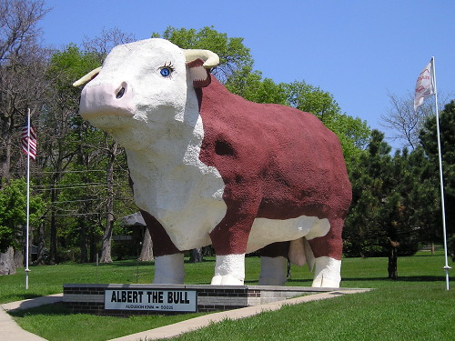
Albert the Bull, the world's largest anatomically correct Hereford, has been looking directly at Division Street on the south side of Audubon since 1964. (His eyes! Such pretty blue eyes!) (5/7/06)

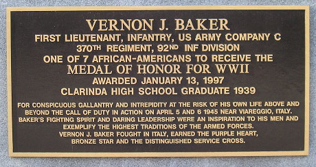
Marker on the Page County Courthouse square, Clarinda (4/15/09)
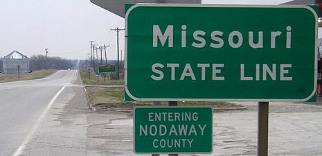
SOUTH End: Missouri state line, now US 71 at line,
Braddyville, Page County IA/Nodaway County MO

Facing south on 18 (4/6/08)
More photos can be found on the US 71 page.
Page created 4/28/20