(July 1, 1920-October 16, 1926)
- In 1920, they knew it as: The Cedar Rapids-Dubuque version of the Military Road, which originally turned south to Iowa City at Anamosa (3 counties)
- IA 28 was designed to be an extension of WI 28, which went from Dubuque to Dodgeville and then north to Reedsburg. In 1923, though, Wisconsin did some reorganizing of its system, and WI 28 became WI 23, breaking continuity after only three years.
- We know it as: US 151 (and all the Business 151's)
- Let's get granular: The following segments are known to remain after US 151 was four-laned between Marion and Dubuque: 1st Avenue in Springville; E34, Main Street, and Old Dubuque Road in Anamosa; Circle Drive, 190th Avenue, 150th Street; Langworthy Road except the part that bypassed Main Street, Military Road, 190th Street, segment of old 151 that dead-ends and ran behind Innovative Ag Services, X44/Business 151, probably Cedar St and 1st Street/IA 38 instead of Main Street in Monticello, Business 151 again, probably Hollywood Road along Main; vacated road north of present route between Jay Avenue and the long driveway to the northeast; Business 151/First Avenue (Cascade); discrete pieces of Reiter Road, Gehl Lane, Fillmore Road, Sacred Heart Lane, 12 Mile Road, McCullough Road, Ryan Road, Military Road (IA 963), and in Dubuque, Key West Drive, Rockdale Road, Locust Street, 14th Street, Jackson Street, 20th Street, and Rhomberg Avenue
- At first, Cedar Rapids and Marion were not only separate, but had a town between them: the village of Kenwood Park, from 32nd Street to just north of 40th Street (the section line, which to the west is 42nd Street). From there to near the intersection of 2nd Street and 7th Avenue in Marion, including a slightly different route northeast of Blairs Ferry Road, it was a rural drive.
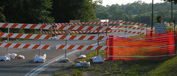
- The intersection of Old Dubuque Road and present 151 was sealed off August 3, 2020.
- Related routes (all but 161/151 unsigned):
- US 161, which IA 28 became; replaced by US 151 in 1938
- IA 303 (II), pre-expressway 151 in Monticello except for IA 38 overlap
- IA 337 (III), pre-expressway 151 through Langworthy
- IA 922 (III), Business US 151 in Cedar Rapids (relevant segment: Everything northeast of its undetermined endpoint on 1st Avenue in Cedar Rapids, including the now-decommissioned part in Marion)
- IA 924 (II), Rhomberg Avenue in Dubuque to Eagle Point Bridge
- IA 963, old US 151 south of Dubuque (includes intersection that was end of US 161)
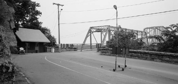
NORTH End: Mississippi River (Eagle Point Bridge), Dubuque, Dubuque County IA/Grant County WI

Facing northeast on 28 (June 1982)
Library of Congress photo
The Eagle Point Bridge was built in 1902, and we know the number was deliberately continued from Wisconsin, so we can say with absolute certainty that IA 28 ended here.
Along the route

Here's how Dubuque Road on the north side of Anamosa was blocked off at US 151 in 2020. (8/23/20)
SOUTH End: Cedar Rapids, Linn County
After IA 13 joined IA 28 at 10th Street in Marion and both went southwest, there are multiple possibilities for IA 28's end:
- The north junction of IA 11, 1st Avenue at College Drive NE (then the southernmost part of Oakland Road)/13th Street SE
- The northeast junction of IA 6 (the Lincoln Highway) two blocks southwest, 1st Avenue at 10th Street E
- IA 40 (Red Ball Route), 1st Avenue at 1st Street W on the west side of the Cedar River. In this case, the 1st Avenue Bridge would have carried five numbers: 6, 11, 13, 28, and 40.
Page created 4/18/20; last updated 10/29/20