
(July 1, 1920-November 3, 1941)
- In 1920, they knew it as: The Waubonsie Trail across Iowa's southern tier of counties, registered April 3, 1916 (11 counties, then 10), with four significant exceptions:
- It went through Bedford instead of Gravity and Conway
- It did not dip down to Lamoni between Kellerton and Leon
- It did not dip down into Missouri between Cantril and Farmington
- At Donnellson, 3 went east and northeast rather than southeast to Keokuk
- An alternate route of the Waubonsie Trail, known as the "Short Line" despite actually being longer, connected Shenandoah to Lincoln via Omaha, mostly following US 275 on the Iowa side.
- We know it as: IA 2, and US 61 from Fort Madison to Burlington
- Why didn't this start as IA 9? Four main east-west highways to the north all continued their numbers from Illinois (5, 6, 7, and 8), so it would have seemed logical. Although IL 9 comes to the Mississippi River at Fort Madison today, it went to Keokuk originally, and 3 turned northeast to Burlington, so it was not a case of a missed continuation.
- If this had become IA 9, and today's IA 9 got numbered IA 3, what would have happened in 1941? This IA 3 became IA 2 to match NE 2, but if IL/IA 9 had already been around for 20 years, maybe Nebraska would have renumbered its #2 instead.
- Let's get granular:
- Fremont County: Railroad bridge, vacated arc through sections 29 and 20, L31, J34, Main and Filmore streets in Sidney (old IA 2), IA 2, L68, J32, 190th Street
- Shenandoah: US 59/Fremont Street, Sheridan Avenue, Clarinda Avenue, Center Street, Anna Crose Highway
- Moved away from downtown from Sheridan to Nishna Road in 1935.
- The arc of trees northeast of present 2 and old 2 follow an older alignment, changed circa 1955.
- Shenandoah to Bedford: IA 2, Business IA 2 in Clarinda (State Street, Glenn Miller Avenue, Washington Street), Tahoe Place, IA 2, Old IA 2 (New Market), IA 2, vacated southward extension of New Market's Main Street and then east on section line (230th Street), Crestwood Avenue and vacated extension east, vacated road on section line, IA 2 (with squared-off corners west of Franklin Avenue), Granite Avenue, vacated extension of 240th Street, IA 2
- The road southeast of New Market was diagonalized in 1921, perhaps explaining the long segment that's either gone or dirt today.
- Bedford: IA 148/Madison Street, Pearl Street, Old IA 2/265th Street
- IA 2 (with 260th Court east of Bedford), 228th Street
- Mount Ayr: Madison, West, and Monroe streets OR Madison, West (short offset), Madison, Taylor, and Monroe streets, then US 169
- The straight route onto South Street came in 1932.
- Kellerton area: IA 2, Main Street, Lincoln Street, 1st Avenue, Clark Street/325th Avenue, 220th Street and straight-east dead end
- Some coding somewhere labels J45 on Kellerton's east side "County Road K", a name it obviously hasn't had for half a century, or even "County Road R", which is wrong because R became P68 on Lincoln Street.
- Decatur County: IA 2, but on an alignment that has little in common with the present route!
- Starting half a mile east of the county line, it was a more winding version generally half a mile or so north, past the south side of the Decatur City Cemetery and then using National Street. Today, only a bit of 155th Avenue and a double-dead-end 210th Street remain.
- Between 212th Avenue and Little River Road, the original and present routes are pretty close, but the first paved version dipped a bit south to avoid a CB&Q line (originally the Des Moines and Kansas City Railroad).
- A 1928 paving document for US 69, and only that document, implies 69's end in Leon was a block north of the present, heavily implying US 65 and IA 3 went east from 2nd Street. But a paving document for Leon to present US 65 the same year shows present IA 2 on 1st Street at least east of Idaho Street (where pavement at the time ended).
- Starting at the curve east of Leon, IA 3 stuck to the section line until about 272nd Avenue, then danced on either side of the present route to about 300th Avenue. The only intact part of the pre-1928 alignment is about a mile and a half of 210th Street running east from R52, part of which is dirt.
- The 1920 and 2020 routes converge again west of R69 (former IA 204).
- Decatur/Wayne county line to Centerville: IA 2, US 65, Liberty Road, IA 2, another part of Liberty Road between 180th and 200th streets, IA 2, 510th Street, IA 2
- Why was there a half-mile north-south jog in the route at US 65 until 1972? Beats me!
- The Walnut Creek bridge for 510th Street (old 2 in the Plano area) was closed in the early 21st century.
- There's a small bypassed segment at T14 now named Sunshine Road; IA 69 ended there.
- Centerville: Old IA 2 with vacated bridge over Cooper Creek that in turn had an older bridge just to its north, Washington Street, Main Street, Van Buren Street, State Street.
- The Centerville Daily Iowegian and Citizen on June 5, 1924, said 3 was to be marked from Washington to State "in such a manner that it will lead onto the public square", implying a block of Main and the northeast corner of the square (Van Buren and 13th streets). The story doesn't mention any previous route, so it could be a reaffirmation of the existing.
- The Iowegian and Citizen on September 16, 1927, said 3 "will be routed so that it will miss the heart of the business district. ... The old route led onto the square off of State street and thence off the square north to Washington and on east. Now the Primary road will enter Centerville on the east over State street and will run thence west to Fifteenth, thence north to Washington and on out of the city." That would confirm that it had been on the square, and was moved to 15th Street, one block east of Haynes and two blocks east of the courthouse. This would prevent travelers on 3 from needing to make left turns at the busy Haynes.
- Multiple articles in the first half of 1934 confirmed the 1927 route (Washington, 15th, and State) shortly before its relocation onto Maple Street, where IA 2 is today.
- Centerville to Farmington: IA 2, 272nd Avenue, 516th Street, 285th Avenue, 520th Street, IA 2, 230th Street, US 63, Old IA 2, Jefferson Street, US 63 (one block), East Street, Mallard Avenue, 230th Street, Otter Trail, 240th Street, Rock Trail, IA 2, 263rd Trail, Old Main Street in Milton, IA 2, 275th Street, North Street in Cantril, Gold Avenue, IA 2, 260th Street, vacated Ivory Avenue, IA 2, Quail Avenue, 250th Street, W40, IA 2 (but with more right-angle turns), vacated line running into 277th Street, River Road
- At the west US 63 junction, the second alignment turned south ¼ mile then paralleled the railroad. This did not change until the Bloomfield bypass was built in 1976.
- The Waubonsie Trail went on the south/east side of the railroad from the point the route turns northeast and uses Karr Avenue, Railroad Street, South Street, and Pine Street to Jefferson Street. By 1922 (when it was changed) the only part of that left was the segment on the other side of the railroad, joining old 2 via 2nd Street near the fairgrounds.
- IA 3 followed the west side of the river for just a bit, crossing the railroad, before crossing the river about where it does today. (A new bridge opened in 2013 just south of the 1948 version.) The road along the river remains; the railroad is gone but its bridge piers aren't.
- Milton, Cantril, and the 260th Street segment were bypassed in 1970.
- Farmington to Fort Madison: IA 2, more or less
- The road between Farmington and Donnellson on the 1914 Lee County map isn't even highlighted.
- Outside of the straight east-west segment east of 140th Avenue through Donnellson, only itty bitty pieces remain:
- 220th Street (dead end) at 140th Avenue
- ¼ mile of W78, forming a corner with vacated west extension of 220th Street
- Paved remnants of 225th and 227th streets near Hillcrest Road
- The east-west driveway in front of Appleberry Orchard met a 248th Street that was vacated earlier this century
- 218th Street east of said vacated 248th Street with a more angled version of X23
- A vacated road running east from the 2/X23 intersection toward where 210th Street abruptly becomes 265th Avenue, then 265th to Bluff Road, then straight south
- IA 3's post-1925 end was a north-south continuation of Bluff where concrete from old US 61 turns into new 263rd Avenue for the Fort Madison bypass
- All of the below is pre-1925 only.
- Fort Madison: Business US 61, 48th Street, Avenue L, 18th Street, Avenue E or Avenue H-2nd Street-Avenue G*, 1st Street, Business US 61, 201st Street (dead end at northeast end of bypass)
- The 1912 Huebinger and 1914 Lee County maps give a strong vibe that IA 3 and IA 20 were on separate routes coming into Fort Madison until 1925, but every state map has them joining west of Fort Madison, and a 1921 construction document makes the joint routing clear.
- In western Fort Madison, the move to Avenue O between 35th and 48th streets happened in 1937.
- A 1934 construction document puts US 61 on Avenue E in eastern Fort Madison. The cover of 1952 construction documents look like 61 is routed on 20th Street and E but a couple individual blueprints mark "US 61" on Avenue H, like it was until the bypass was built. Any clarifications would be appreciated.
- A little jog in the route at 6th Street was not ironed out until the early 1950s, lending credence to the E Avenue route.
- A construction project near the BNSF railroad bridge over the Mississippi River in 2020 found artifacts from "what may have been the first European settlement site in Iowa," the remains of Old Fort Madison. The fort was built in 1808 and abandoned in 1813. (Although Julien Dubuque was in Iowa first, the land that became the city of Dubuque wasn't open for settlement until 1833.) This project ripped up the entire roadbed on Avenue H, built in 1952 and expanded to four lanes from brick pavement, barely missing the Sheaffer pen factory. (The factory closed in 2008; the museum closed in 2018.)
- The original route ran right beside the walls of Fort Madison Penitentiary until 1952, when it was moved a block west. Access from state-maintained roads to state institutions is important, but ... just over the wall?
- Fort Madison to Burlington: US 61 but with the following:
- 345th Avenue, Lost Creek Road, and 354th Avenue
- A vacated road to the north of present 61 in the area of the intersection with IA 16, meeting that road about where 16 turns southeast today and then going east on the north side of the tree line
- The Lee County map has the first Skunk River crossing north of the CB&Q, where US 61 later goes; the Des Moines County map has a strip south of the railroad, of which only scraps remain.
- Burlington area: Old Highway 61, X62, Summer Avenue, Maple Street, Central Avenue
- Related routes (all unsigned):
- IA 937 (I), old IA 2 through Bloomfield
- IA 939 (I), Liberty Road east of US 65
- IA 940 (I), old IA 2 segments in the western half of Appanoose County
- IA 957 (II), old IA 2 on the east side of Bedford
- IA 960 (I), old IA 2 through Clarinda
- IA 971 (I), old IA 2 west of Shenandoah, now J32 and L68
- See also: Burlington Highway Chronology (1922 map)
WEST End: Missouri River (CB&Q Railroad bridge), Nebraska City NE, Fremont County IA/Otoe County NE

You can't get more definitive than this. The top line is for the new bridge, opening in 1930 with the paving.
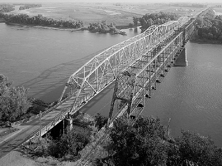
Facing east from Nebraska; railroad bridge is on right
Library of Congress photo (August 1984)
The bridge opened with great fanfare on October 17, 1930, and was toll until 1955.
Along the route
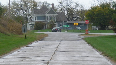
Facing east (10/18/20)
State Street on the east side of Centerville has much of its original concrete, with old-style curbs. It also goes past the cemetery, which is common to 1920 primaries.
EAST End (1): Burlington, Des Moines County
There are two possibilities for IA 3's original east end: Either it ended on Central Avenue at Washington Street, where it met IA 8, or continued with IA 8 on Washington to the MacArthur Bridge on the Mississippi River. On November 3, 1924, the redundant duplex with IA 20 was cut.
EAST End (2): Mississippi River (BNSF Railroad toll bridge), Illinois state line, Fort Madison, Lee County IA/Hancock County IL
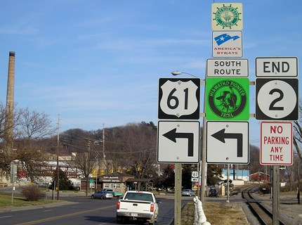
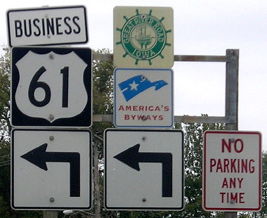
Facing east on 3, now heading north on Business 61 (12/18/06 and 10/4/15)
This looks familiar! But it was only the end for two months in the winter of 1924-25, getting cut in both the Great and Lesser Truncations. Sometime before 1936, the east-west route was redesignated through Fort Madison.
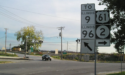
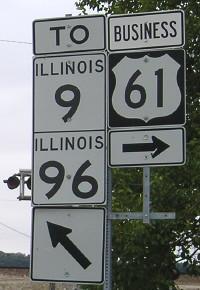
Facing south on 61 (10/21/05 and 10/4/15)
The black SUV has just entered Iowa on IL 9/IA 2. In 2002, these signs were on a wooden pole. After paying the toll and crossing the bridge, you start on IL 9 — which, as a reminder, was NOT on the Illinois side in 1920 and thus did not lend itself to making the route IA 9.
EAST End (3): IA 20, now vacated 26th Street at X23, Fort Madison, Lee County
The exact location of this endpoint was on the section line, just a hair east of the current US 61 freeway's northbound exit to IA 2, and west of where IA 2 met US 61 pre-bypass. You can decipher the location today because it's where concrete from old US 61 turns into new 263rd Avenue.
Page created 5/24/20; last updated 4/28/21