(July 1, 1920-September 4, 1941)
- In 1920, they knew it as: The west half, nothing until it became the west half of the Herbert Hoover Highway (registered August 15, 1923); the east half, the King's Highway (registered June 28, 1915) and/or the Davenport, Tipton and Cedar Rapids Short Line (3 counties)
- We know it as: The streets in Jason Hancock's Highways of Iowa City, F44, IA 38, IA 130, and the streets in Jason Hancock's Highways of Davenport and Bettendorf
- Let's get granular: See Jason's pages for the city alignments at either end. Outside of there: Herbert Hoover Highway, F44, vacated Cedar River bridge running into Madison Street in Rochester, 285th Street, IA 38, Logan Avenue, IA 38, Moscow Road, F36/South Street, IA 38, IA 130, Y14, 5th-Main-1st streets in Bennett, Y14, 250th Street, IA 130 (except a squared-off corner at Y30), Northwest Boulevard
- It could have just gone straight south on 5th/Y14 in Bennett, but I think a routing down Main is more likely. Either way, it was gone when the road between Bennett and New Liberty was moved a mile north in 1922, just before the route in Scott County was paved.
- Related routes:
- IA 139 (I), the Herbert Hoover Highway between Iowa City and IA 38, sliced off from 74 in the 1926 highway system
- About three years later that became part of IA 1 (II) until 1962, when 1 was redirected to Anamosa and the road through West Branch became IA 979.
- IA 150 (II), as part of that number's creation between Davenport and West Union via Cedar Rapids that overlapped 32 miles of US 30
- Allegedly, this was an attempt to create an extension of US 150, which ended either in Rock Island or on the Centennial Bridge on the state line. However, it would have been nonsensical, as 150 is an east-west number that is now a diagonal route and the Iowa portion would have been much more north-south.
- IA 130 (III), Tipton to Davenport, when IA 150 was cut in the Great Renumbering of 1969
- Point of interest: The section west of IA 38 has carried three numbers (74, 139, and 1, not counting secret IA 979); the section east of IA 38 also has carried three numbers (74, 150, and 130).
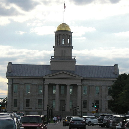
WEST End: IA 11/IA 40, now Iowa Ave. at Dubuque St., or IA 7, now Dubuque St. at Washington St., Iowa City, Johnson County

Facing west on 74 (8/24/19)
IA 74's last five blocks on Iowa Avenue gave westbound drivers a straight-on view of the Old Capitol. It almost certainly turned a block south so that the intersection of Dubuque and Washington, now the north end of the Iowa City Ped Mall, was the 1920 nexus of routes here.
Along the route

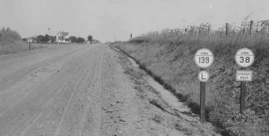
Facing north on 38 at 285th Street (late 1920s)
© Iowa Department of Transportation. All rights reserved.
This is half a mile north of where IA 38 meets present-day F44 in Cedar County. In the early 1920s, IA 74 would have been ahead and left. Note the "L" and "straight ahead" signs, which were rapidly discarded in favor of arrows.
EAST End: Davenport, Scott County
There are four potential endpoints for IA 74 in Davenport:
- Eastbound Lombard Street at Main Street, where it met IA 20 (future US 61); this is unlikely because it was out of the central city
- Southbound Main Street at Locust Street, three blocks south of the above, where it met IA 7 (future US 32); also unlikely for same reason, but either could have become 74's end in 1926. Thus, 74 could have had both ends at 7 as each connected Iowa City and Davenport.
- Southbound Main Street at 4th Street, where it met IA 2 (the Great White Way) and possibly also IA 99, at Davenport City Hall
- Eastbound 4th Street at Perry Street, where IA 7 turned south to the Government Bridge and IA 99 continued along the Mississippi River
Page created 4/18/20; last updated 7/11/20