
(July 1, 1920-present)
- In 1920, they knew it as: Nothing west of Sioux Rapids; part of the Des Moines-Panora-Spirit Lake Highway from Sioux Rapids to Pocahontas; east of there, the Cherokee, Humboldt, Waverly, and Oelwein Air Line; pieces of the Elkader and North Iowa Pikes. The entire route west of Strawberry Point later became the Rainbow Trail, registered May 16, 1922 (12 counties)
- We know it as: IA 10 except the part north of Hawarden, IA 4 between IA 10 and IA 3, IA 3 from Pocahontas to Strawberry Point, parts of IA 13 and US 18
- Let's get granular:
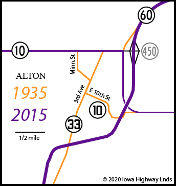
- Hawarden to Alton: IA 10
- The highway between Orange City and Alton was paved in 1920. It would not get any connecting pavement until the summer of 1936, when IA 33 was paved southwest of Alton. There wouldn't be any extension of the concrete on 10 west until 1946 and east until 1954.
- Alton: Minnesota Street, 3rd Avenue, 10th Street, Division Street, and a Floyd River crossing south of Division, using part of Homestead Lane and rejoining 10 where the IA 60 four-lane blows through the section line. (The highway had to dip because the railroad crossed the Floyd at that spot.)
- Alton to Peterson: IA 10
- A grading plan dated 1949 would have sent 10 straight east on 450th Street and then diagonally cut southeast on the north side of Granville. This did not happen.
- From the corner south of Sutherland to a mile west of the O'Brien/Cherokee line, 10 followed a more jagged/stairsteppy route. The only remaining piece is formed by Wilson and Yellow avenues with a vacated crossing of the Little Sioux River, going past the Prairie Heritage Center.
- From half a mile east of the O'Brien/Cherokee line to 120th Avenue (former C&NW tracks), some dips south of the present route, but only a bit of 110th Avenue remains.
- It looks like 4th and Main streets could be a first alignment in Peterson, and the Iowa Geographic Map Server overlay uses 4th and Pine, but a 1924 construction plan rules out both of these.
- Peterson to Laurens: 160th Avenue, 510th Street, M36, Bluff Street, Main Street (broken), M36, High Street, vacated road south and east from the cemetery joining 86th Avenue, C13, 90th Avenue, 450th Street, M54, IA 10
- Between 1924 and 1934 it followed 505th Street between Peterson and Linn Grove.
- This explains why "Main Street" in Linn Grove seems so out of place. The straighter crossing was built in 1943 and the bridge over the main channel was donated to a World War II scrap drive (Storm Lake Pilot Tribune, December 2). A bridge over a side channel in Linn Grove Dam Park is abandoned today.
- "Linn Grove. Pop. 500. Hotel — Wm. DeLong, Am., $1.50. Blacksmith — Nels Fuller. Gas and Oils — Brostad and Anderson Co." — 1912 Buena Vista County map
- The 1914 map shows the primary never went through Marathon.
- Laurens: 440th Street, Section Line Road, 3rd Street, Veterans Road, N28
- "The" stoplight is at 3rd and Main.
- Laurens to Pocahontas: IA 10, 210th Avenue, C26, IA 4
- It's not entirely clear if IA 10's overlap with IA 4 south of Havelock was dropped when IA 3 was designated. It should have, but there have been weirder redundancies-for-history's-sake in the system.
- Pocahontas, 1920-22: Railroad Street, 4th Avenue, Court Square, Main Street, IA 3
- Pocahontas, 1922-45: IA 4, IA 3
- A construction plan dated 1922, with what's now IA 3 between IA 4 and Railroad Street, is tacked on to a plan dated 1915 (!) for Pocahontas to Gilmore City. It seems to me that the 1920 routing listed here would serve the triple purpose of passing the courthouse, going through downtown, and avoiding two RRX's. IA 17, now IA 4, could stick to its straight north-south path without worrying about missing downtown because 10 took care of it.
- Remember, no state highway between Cherokee and Pocahontas for two more decades!
- Pocahontas to Rowan: IA 3, Birch Avenue, 230th Street, 4th Avenue SW and Sumner Avenue in Humboldt, Main Street in Dakota City, C44, P56, IA 3, Quebec Avenue, 210th Street, C44, Oak and Main streets in Goldfield, IA 3, 220th Street, 212th Street, Broadway Street and Pritchett Avenue in Rowan
- RIP the extinct map dot of Unique, at the corner of P29 and C44, without so much as a cemetery to remind us.
- RIP Owl Lake, a swamp wetland just east of P66, drained in the late 19th century leaving Lake Township without a lake.
- There was a different route between Thompson Avenue and the former railroad crossing smoothed out in 1924, according to a Service Bulletin that year: "The attractive curve shown in the picture above eliminates five right angle turns formerly in primary road No. 10 between Clarion and Rowan in Wright County. Those turns ... occurred in less than a mile of road immediately west of the town of Rowan. The final right angle turn was snug up against the C&GW main line track." The construction documentation for this and a Wright County Monitor story are both from 1921, a surprising lag time for the period.
- A potential route on 215th Street and Youngblood Avenue, which also would have gone through downtown Rowan, was bypassed in the early 1920s at the latest.
- Rowan to Strawberry Point: IA 3, with the following exceptions:
- Terrace Avenue and 220th Street northwest of Shell Rock, and Main, Cherry, and Barbara streets in Shell Rock
- A railroad crossing east of Mallard Avenue instead of west, following the trees, and a harder corner at Wren Avenue and 150th Street
- A corner at 10th Avenue and 20th Street southwest of Waverly, moved just north of the railroad in 1921
- From 1921 to 1927, the road east of Waverly was on 220th Street, a mile north of the present route. This route would have needed two north-south blocks (8th Street?) to get to 2nd Avenue and 10th Street heading east, and avoided two crossings of the Waterloo, Cedar Falls & Northern interurban/railroad. The intersection a mile north of present US 63/IA 3 is the extinct map dot of Artesian.
- Frederick Avenue and Charles Street in downtown Oelwein
- A hard corner at L Avenue and 40th Street east of Oelwein
- East of Strawberry Point (i.e. the below bullets), IA 10 overlapped with IA 13; it was truncated in 1926 and extended to Luxemburg in 1930, then Dubuque in 1939.
- Strawberry Point to US 52: IA 13 but a bit more winding version, IA 56, Bridge and High streets in Elkader, IA 13, Falcon Avenue (dead end), Fawn Hollow Road (short piece east of Roberts Creek), IA 13
- There was a particularly sharp pair of curves at the X3C/Grandview Road intersection, and a bit of the old road is a curved driveway on the east side of present 13.
- A few maps call Roberts Creek Pony Creek.
- A construction document from 1922 shows the original road in the vicinity of the IA 128 intersection on the west side of a creek that appears to have completely vanished, probably a few hundred yards west of the present road if that.
- US 52 to US 18: The section line north from near US 52 (at the "Jct 52" sign at the present north end), along the west edge of the cemetery, then the abandoned diagonal northeast
- US 18/52 junction to McGregor: US 18 with Giard Road, 148th Street, the parking lot of Maggie’s Diner, 145th Street; then IA 76/Business US 18
- Related routes:
- IA 264, spur to Linn Grove created when IA 10 was rerouted, using first the east-west connection to US 71 and then the north-south connection to IA 10
- IA 390, spur to Marathon created when IA 10 was rerouted
- IA 353, spur to Rowan, but created years after IA 10 was rerouted
- IA 915, three blocks in downtown Oelwein, changed December 1, 1986
WEST End: Hawarden, now IA 10/10th St. at Central Ave., Sioux County
A letter to the editor January 12, 1928, in the Hawarden Independent, containing a resident's "pertinent road suggestions," includes: "Highway No. 10 which now terminates at Kansas street in Hawarden should be extended through the city directly west to the bridge and state line west of Hawarden." Ding? Not exactly. Hawarden doesn't have a Kansas Street anymore, nor does it have a Wisconsin, Iowa, or Dakota Street. It turns out the change came less than two years later, in June 1929. Kansas Street became Central Avenue, two blocks east of the present IA 10/12 junction and at the north end of Hawarden's business district.
IA 12, after its extension in 1931 to circa 1955, came into Hawarden on D Street instead of E and then went east two blocks to meet 10, at the north end of downtown Hawarden.
Along the route
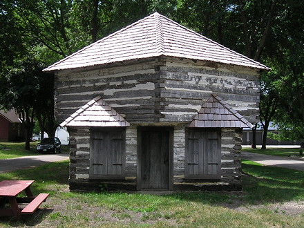
This glacial boulder
centers on the spot where Fort Peterson was built in 1862 by a company
of cavalrymen who were detailed by Colonel James Sawyer, commandant of
northwestern Iowa forces. The fort, surrounded by a high stockade, was
large enough to provide officers' quarters, barracks for a company of
cavalrymen, a mess hall, armory, and horse stalls.
Fort Peterson was one of several frontier posts erected at this time to
meet the thread of bands of marauding Indians. As that threat
diminished, men were gradually withdrawn until there remained only a
sergeant with a squad of men. At last these departed also. The fort, no
longer needed as a bulwark against the Indians, was dismantled. Both
Fort Peterson and the pioneers it protected have passed into history.
— Undated plaque at the site of the above re-created fortification, 2nd
and Park, Peterson (photo 7/17/20)
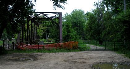
This is the abandoned bridge just north of Linn Grove mentioned in the listing. The bypass is blocked, too. (7/17/20)
Gilmore City, a town of
1,000 population, is one of the most beautiful and enterprising little
cities in Northern Iowa. It is located 30 miles northwest of Fort Dodge
and 100 miles northwest of Des Moines in what is admitted to be the most
productive and richest farming territory in Iowa, there being no
sloughs, no waste land and every acre producing something. Members of
the Gilmore City Commercial Club, a live organization of the city,
declare the town "the biggest town of its size on earth and every
citizen a booster."
— Huebinger's Map and Guide for Des Moines, Fort Dodge, Spirit
Lake, and Sioux Falls Highway (1912)
Facing northeast (probably 1923)
© Iowa Department of Transportation. All rights reserved.
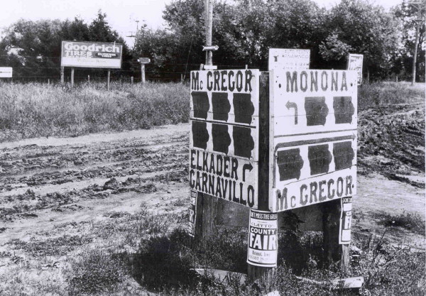
This, to my knowledge and surprise, is the only image I have found of 1920 system highways with their state-outline markers. (Newspapers of the time had extremely few to no local photos.) The relative location of this point is where the now-abandoned diagonal from IA 13 met US 18; the absolute location is just south of present 18 and just east of the FS station. You can't really see the numbers in there, but top left would be 10, 13, 19; bottom left, 10, 13, 20; top right, 19 and 20; bottom right, 10, 13, 19.
EAST End: Mississippi River ferry landing, McGregor, Clayton County IA/Crawford County WI
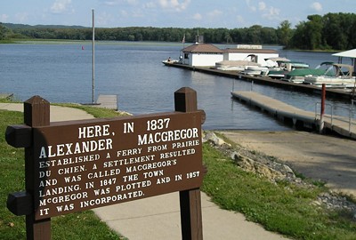
Facing east (9/7/06)
This is at the end of Main Street in McGregor, as 18 (now Business 18) turns north toward Marquette and the bridge to Wisconsin. But until mid-1932, this is where you connected to Wisconsin, and thus IA 10 and IA 19 would have ended here, and IA 13 at the start.
Facing east (9/7/06)
Page created 3/4/20; last updated 9/7/20