
(July 1, 1920-present)
- In 1920, they knew it as: "The road from Akron to Westfield and along the Broken Kettle Road to Sioux City" (Le Mars Semi-Weekly Sentinel, August 1, 1919); from Sioux City to Council Bluffs, the King of Trails; from Council Bluffs to Tabor, part of the Waubonsie Trail Short Line; and nothing in Fremont County, although it overlapped with IA 4 (7 counties, then 4)
- We know it as: IA 12, US 75's old route in western Iowa, IA 127, old IA 183 and the Lincoln Highway, old US 275, and US 275
- Let's get granular:
- Hamburg to US 34: US 275, including the old (pre-2006) route through Sidney and Northridge Road at the north end of the bypass, and dead-end Irish Avenue at H30
- Glenwood: Not H30/old IA 949, but a vacated road paralleling it to the southwest, Ives Avenue, Green Street (now broken at Keg Creek), Vine Street, and Sharp Street, turning at the Mills County Courthouse
- Glenwood to Council Bluffs: L35 (before 2003, still US 275) from Glenwood to the Iowa School for the Deaf
- Council Bluffs: Harry Langdon Boulevard, South Avenue, Tostevin Street, Graham Avenue, High Street, 16th Avenue, 3rd Street, 9th Avenue, Main Street, Broadway
- Council Bluffs to Mondamin: L20, including the original Lincoln Highway between Council Bluffs and Missouri Valley (see more on the IA 6 page); IA 127 from the L20 junction westward
- With Loess Hills Cut original route: vacated north extension of Ski Hill Loop and Honey Creek Lane
- Little bit of L23 and 285th Street at the extinct map dot of Calhoun at F50
- Mondamin to Onawa: K45, Eden Avenue (broken at ditch), F20, K45, Hickory Avenue, 6th Street
- Onawa: IA 175/Iowa Avenue from the Monona County Courthouse to 10th Street
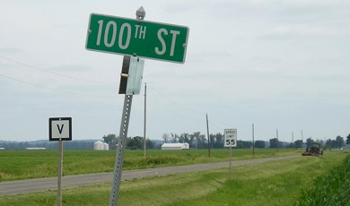
- Onawa to Sloan: K45, K64, 165th Street, K45, Elder Avenue, 145th Street, Dogwood Avenue, 110th Street, Cedar Avenue, 100th Street, Dillon Avenue
- The segment from Onawa to Sloan was diagonalized in 1923, as/after the route was paved from the Monona/Woodbury county line north to Salix, kicking out all of the stairsteps in between.
- Sloan: IA 141, Rebel Way (formerly 1st Street), Evans Street
- Sloan to Salix: K42, 290th Street, Carroll Avenue
- Salix: Tama Street, Willow Street (including small vacated section east of Talbot Street), Tipton Street
- Salix to Sioux City: K45, Benton Avenue (and vacated arc north of 240th Street), K45, Barker Avenue (and vacated line south of 230th Street), 220th Street, K29
- The segment frrom Salix to Sergeant Bluff was paved and diagonalized in 1922.
- Sioux City: Lakeport Street, Morningside Street, Jay Avenue (3 blocks), Rustin Street (4 blocks), Leech Avenue (2 blocks), Fairmount Street (2 blocks), 2nd Street (NB)/1st Street (SB), Westcott Street, a still-existing bridge that's been filled under, Lewis Boulevard, 4th Street, Court Street (1 block), 5th Street, Nebraska Street, 27th Street, Stone Park Boulevard, Broken Kettle Road
- Sioux City to Akron: K18, IA 12, and possibly Hardy 4th, and Reed streets in Akron (see discussion below)
- Point of interest: The original route passed by four courthouses: Fremont (Sidney), Mills (Glenwood), Pottawattamie (Council Bluffs), and Monona (Onawa). The post-1924 route passed none directly and only had two county seats (Onawa and Sioux City).
- Related routes:
- IA 475, the diagonalized US 75 between Onawa and Sergeant Bluff, after 75 was put onto I-29
- IA 970, the number for Woodbury County's portion of 475 starting in 1980 and gradually reduced in size until it was 164 feet long in 2003
- See also: Sioux City Highway Chronology, Council Bluffs/Omaha Highway Chronology
| IA 12 endpoint history | |||
| FROM | TO | NORTH | SOUTH |
| 7/1/20 | 11/3/24 | Akron |
Hamburg/Missouri state line |
| 11/3/24 | 10/16/26 | IA 6 (US 30 at 6th St/L20/old IA 183, Missouri Valley) | |
| 10/16/26 | 10/29/29 | US 20 (Court St at 4th St, Sioux City;
all Sioux City after here) |
|
| 10/29/29 | 7/8/31 | US 20 (Wesley Pkwy at 5th St) | |
| 7/8/31 | 1/15/35 | IA 10 (northbound Ave D at 10th St, Hawarden) | |
| 1/15/35 | 6/21/39 | IA 10 (eastbound 10th St at Central Ave,
Hawarden) |
|
| 6/21/39 | 8/11/49 | US 20 (Wesley Pkwy at 3rd St) | |
| 8/11/49 | Late 1955 | US 20/77 (Pearl St at Gordon Dr) | |
| Late 1955 | 10/10/57 | IA 10 (northbound Ave E at 10th St, Hawarden) | |
| 10/10/57 | 10/1/58 | US 20/Combination Bridge (SB I-29 at US 77) |
|
| 10/1/58 | 6/29/79 | I-29 (Riverside Blvd exit) | |
| 6/29/79 | 2000 | US 20, east side Sioux City | |
| 2000 | Present | US 20, east side Sioux City (official) | |
| I-29 (Riverside Blvd exit) (signed) |
|||
NORTH End: Akron, Plymouth County
A 1934 construction document for IA 12 through Akron shows that its current route was built then and not 1920. However, it does not depict what had been the route, and both the Akron Register archives and all relevant maps yield nothing. The most likely route is coming north on 4th Street, then west on Reed to end in downtown. Then, between 1931 and 1934, after it was extended to Hawarden but before the present route was built, I think it went east on Reed and north on 8th Street, while IA 5 (the east-west road) stayed going west on Reed to downtown.
Along the route

This mural is at the northwest corner of 4th and Court streets in Sioux City, where IA 5/12/23/29/34 intersected. (10/2/20)
SOUTH End (2): IA 6, now US 30/Lincoln Hwy. at L20/6th St., Missouri Valley, Harrison County
Facing east on present US 30, but heading south on IA 12 (7/12/13)
Despite being a primary running the west edge of the state, IA 12 did not have its own road at all south of Missouri Valley. It had overlaps with IA 6, IA 8, and IA 4. There wasn't any reason it couldn't have stopped at Council Bluffs to begin with. The IHC came to its senses in 1924 and cut the route in half.
SOUTH End (1): Missouri state line, Hamburg, Fremont County IA/Atchison County MO
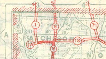
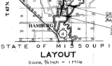
1927 Missouri state map from MoDOT archives / 1928 construction
document, Iowa DOT archives
(1. I am glad Iowa's maps are better detailed. 2. "Missoupi" is likely
an accidentally funny scan artifact.)
Facing south from the state line (6/12/06)
This road is entirely unconnected to any other paved road in Missouri; if you follow it, you will eventually turn back northward into Iowa and enter Hamburg on the road that goes under the I-29 bridge at the "IA 333 1 mile" sign. Route V is on the west side of the Nishnabotna River and residents in that clipped corner have no access to the rest of Missouri without entering Iowa. (But, in a geographical quirk, they do have access to an isolated part of Nebraska!)
Facing north (10/2/15)
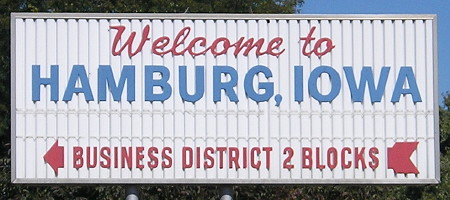
This is on G Street, two blocks north of the present junction of US 275 and IA 333, and has since been replaced with a digital sign.
Facing south (10/2/15)
Downtown Hamburg is two blocks west (right), at Main and E streets; E becomes L44. Ahead is IA 333 and the way to Route V. For about five years, 333 went west here, to the business district, and then south on Main. I think it's logical that original IA 4/12 did the same, exiting Hamburg on Main and taking that to the state line.
Page created 4/29/20; last updated 12/18/20