
(July 1, 1920-October 16, 1926)
EAST! WEST!
CROSSING IOWA
The Standard Automobile Route is the Official Trans-Continental Route. It is now and ever was so.
The Government
standardized this route, for the ox team, the stage coach and the
mail route, because of its directness, shortest distance, topography and
the conditions of the soil. Along this trail is strewn the history of
the nation, who's [sic] institutions of interest and influence have
formed the great link that binds the west to the east. The
accommodations along this route are surpassed by none. You will be
welcomed by the people of both cities and country. The Official
Trans-Continental Road Association has seen to it that your pleasure,
comfort and needs will be supplied at the minimum cost of expense. You
will never regret selecting this route for your trip.
— Huebinger's Map and Guide for Iowa
Official Transcontinental Route (1912)
- In 1920, they knew it as: The Lincoln Highway (13 counties)
- We know it as: The Lincoln Highway (heh). Old US 30/IA 183 from Council Bluffs to Missouri Valley, then US 30 across the rest of the state
- Few pieces of modern US 30 overlap with its route from 1920, and little of it east of Carroll even overlaps 1950.
- Let's get granular: The Lincoln Highway Association's map covers everything you want to know, but I'm writing it out anyway. (Also, the LHA set contains changes made between 1913 and 1920, only some of which I will describe below.) Huebinger's Map and Guide for Iowa Official Transcontinental Route (1912) ("Huebinger" below) is another major source.
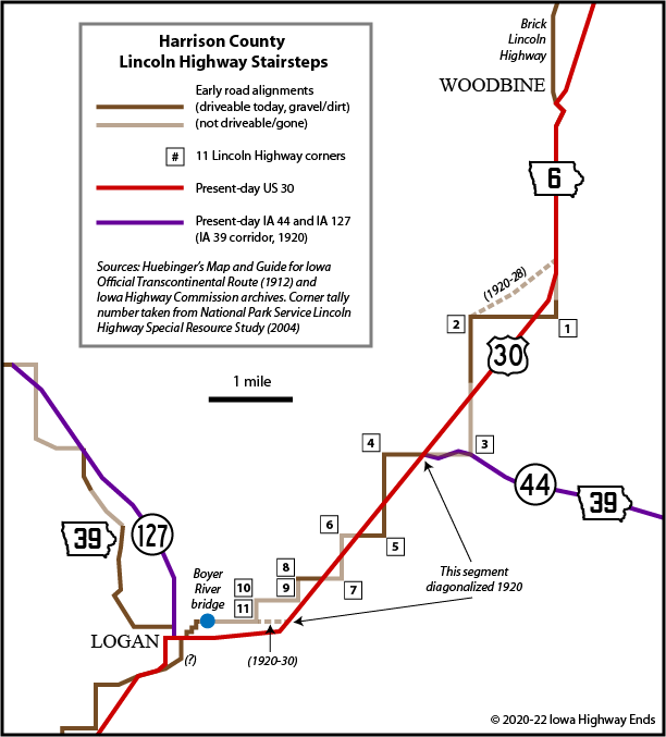
- State line to Logan: Ak-Sar-Ben Bridge, Broadway and North Broadway in Council Bluffs, L20 (IA 183 until 2003), US 30, Niagara Trail (and vacated southward extension to 280th Street at 30), F50, US 30
- Intersection with Mahogany Road was altered in 2016.
- In 1912 or 1913, after Huebinger but before the 1914 county maps, the route was changed north of Missouri Avenue from a vacated road paralleling Pigeon Creek plus Ski Hill Loop to a route to the east with a kink at the L36 junction. It resumed the old route right where Ski Hill Loop ends today at Hitchcock Nature Center.
- From today's end of Ski Hill Loop to Honey Creek Lane was one of the most notorious, and now completely vacated, parts of Iowa's original Lincoln Highway. A new grade was completed in 1922. See "Along the route" below.
- Where Honey Creek Lane turns sharply east to meet L20 is where it intersected the original route. The curve at Honey Creek (the creek) was made more gradual in 1931.
- From Honey Creek (the map dot at Sumac Road) to York Road, the original route hugged the tree line instead of the railroad. A realigned route left a sliver just wide enough for houses. The only pieces left are a portion of Teal Lane and Cornelia Lane and Wood Lane in Loveland. The only blueprint set I stumbled upon is severely mislabeled and missing the cover sheet, but I believe it's a 1920-21 time frame.
- The Lincoln Highway first used Lima Trail and Kermit Place (north-south part) and vacated extension southwestward, but this may have already changed by 1920.
- The Missouri Valley Welcome Center has a reproduction of Lincoln Highway pavement on the former roadbed of Monroe Avenue. In 1919-20, the route was straightened away from this, a short segment of present Monroe, and a vacated road northeast to 290th Street. The modern houses are just on the north side of the old alignment.
- Logan: 11th Street, 3rd Avenue, 6th Street, 4th Avenue, 5th Street, 5th Avenue, 4th Street, across Boyer River on extension of 4th
- That's Huebinger's route and could have had a couple corners knocked out by 1920. A 1928 paving document, later revised, indicates an intention to pave 11th Street (it crosses the section line before turning north). Another page of the same plan specifically notes a Lincoln Highway post at Maple and 7th, where US 30 turns today, indicating the highway had been put on the alignment by that time. The current route makes more sense from the beginning, considering it passes by the Harrison County Courthouse.
- If Huebinger's route was used any time after 1920, only one
block of US 30 in Logan has been in the primary system
the whole time: 7th Street between 3rd and 4th avenues. Not
coincidentally, this is in Logan's business district.
- Boyer River to Woodbine: South of IA 44, the present diagonal appears to have been constructed in 1919-20. But, despite a noticeable change in the 1924 vs. 1925 state maps, the continued diagonal northwest doesn't come around until 1928. Before that, it went straight east on the section line to Sixmile Creek (today's IA 44 is slightly curved), straight north on the half-section line to run into Quincy Trail, and then a bent diagonal from the intersection of Quincy Trail and 215th Street northeast to just north of the intersection of US 30 and 210th Street. See map in "Along the route" section.
- The remaining stairstep segment of 240th Street, Parker Trail, and 231st Street is a Heritage Byway Loop today.
- Woodbine to Dunlap: Lincoln Way, Bus Brown Drive, 180th Street (formerly direct connection to Bus Brown), Sawyer Trail, 166th Street, Spokane Avenue, 128th Trail, Toledo Avenue
- Dunlap: 2nd Street (broken just north of US 30), Eaton Street, US 30 (one block), IA 37/Iowa Avenue
- Dunlap to Denison: Dunlap Street, US 30, Pearl and Franklin streets in Dow City, M14, Arion Avenue, pick-your-stairsteps in Arion, Lincoln Way, Boyer Valley Road
- Nearly every block in Arion is tagged in at least one iteration of the Lincoln Highway before paving in 1929 put US 30 on the other side of the railroad. Huebinger used 1st, Main, 3rd, State, Catherine, Burton, 5th, Frederick, and 6th streets; the Heritage Byway uses Western Avenue and 2nd, Main, 3rd, State, Catherine, Grace, and 6th streets. Just wander through town, it doesn't take long.
- Denison (by 1926): Road on south side of railroad, vacated road across the Boyer River, 5th Avenue S, Main Street, US 30
- See the Denison Highway Chronology for the maze of streets before this alignment, which was set at an unknown date and changed with paving in 1929.
- Denison to Carroll: US 30, except for a spot of M Avenue between Denison and Vail; 390th Street; 1st and Clinton streets, US 30/1st Street, and Park and 3rd streets in Westside; 400th Street; 200th Street
- The at-grade crossing west of Westside, just north of the present overpass, was the northernmost point of the national Lincoln Highway. A remnant of the first overpass can be seen on the farm south of today's route.
- Carroll: 3rd Street on the west, US 30 out to the east. Modern Lincoln Highway signage uses Carroll Street; Huebinger marks it on Main. I would actually give Main the upper hand in the 1920s because 1) It creates a turn at the courthouse 2) It's Main Street 3) IA 18, having joined IA 6 back at Jade Avenue, most likely continued north on Main.
- "Practically half of the Lincoln Highway across Carroll County will be paved with concrete, 18 feet wide, during the summer of 1920," the Carroll Times reported April 10, 1919, when supervisors voted to accept $163,000 in government aid. BZZT. None would be paved until 1930-31.
- Carroll to Scranton: US 30, Zephyr Avenue, E39, N65
- Huebinger's route goes through Glidden on Nevada, 1st, and Colorado streets. This is absolutely incorrect; Idaho Street, not Nevada, connected present 30 with the business district. The route changed by April 1914 based on the erection of the Gregory Markers east of Ralston.
- Moving the route out of most of Glidden eliminated one business district and two railroad crossings.
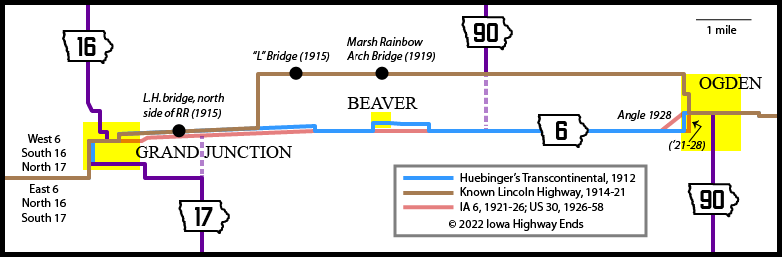
- After Zephyr Avenue, the original IA 6 does not share any length with present US 30 until the Shady Oaks corner east of Marshalltown. However, the route from Grand Junction to Ogden was changed in 1921 (see map) to present 30.
- Scranton: IA 25; State, Main, Elm, and Kendrick streets
- The route was shifted a block south from State to Madison no later than 1924.
- US 30 kept a route through town until 1936, when the overpass on the west side of Scranton (now part of IA 25) opened. This was the last at-grade crossing of US 30 at the Chicago & North Western Railroad in the state (Jefferson Bee, October 13, 1936).
- Scranton to Grand Junction: E53, IA 144
- This route, paved by the end of 1924, is a notable stretch of the Lincoln Highway because of Greene County's early enthusiasm for the good-roads movement. There would be no additional concrete connection for five years.
- Approaches to both the Eureka (Raccoon River) and Head (Buttrick's Creek) bridges were smoothed out in 1920.
- A tiny kink in the Lincoln Highway west of Grand Junction was fixed in 1921, in a deal that resulted in a farmhouse physically being turned around to face the new road (Jefferson Bee, September 1, 1920).
- At the same time the Lincoln Highway was being (re)marked across the country in November 1920, the oldest resident in Greene County celebrated his 97th birthday. That means he was born in 1823, when there were only 31 states — and less than three years before John Adams and Thomas Jefferson died. (Jefferson Bee, November 3, 1920)
- Grand Junction to Ogden (1914-21): Main, 16th, and Sandoe streets; vacated road on north side of railroad; Y Avenue, 210th Street; NW 8th, Elm, and NW 7th streets
- The routing of IA 6 between Grand Junction and Beaver shown in the 1919-21 state maps is either incorrect or reflects a very short-term and perhaps-ignored change. The Jefferson Bee on June 4, 1919 repeated an article from the Ogden Reporter that said the Lincoln was being changed to bypass Grand Junction entirely, on an alignment using B Avenue in Boone County and then 230th Street. It is highly unlikely this happened in the field. Grand Junction immediately sought to get the highway back, and won, as reported in the Bee on September 1, 1920 and subsequent Greene County Supervisors minutes from September 23 printed October 13. All other sources — the 1914 county maps, the modern LHA Map Pack, ISHC construction plans, and the simple fact there has never been a road running directly east of the E53/IA 144 junction — never show this occurring.
- At that September 23, 1920 meeting, the Greene supervisors supported the route on the south side of the railroad that would be built the following year.
- Either way, three bridges from the 1910s specially made for the Lincoln Highway, and all extant today, were bypassed by the end of 1921. See map below.
- Grand Junction to Ogden (1921-26): Main Street, 222nd Street, US 30, 219th Street (with dead end), Division Street, SW 7th Street
- This segment includes the Three Bridges Park: The original Lincoln Highway bridge on the north side of the railroad, the railroad bridge (upgraded in the 2010s), and "old 30" with its original ISHC bridge that was bypassed in 1958.
- The Heritage Byway is signed along SW 8th instead of SW 7th in Ogden, reflecting the original but extremely short-lived alignment through Beaver. The ISHC's ratification of county system maps on February 13, 1914, included the north route described above. Lincoln Highway State Consul W.F. Coan later admitted that Beaver's inclusion in the 1915 Official Guide was "an oversight". (Jefferson Bee, February 25, 1920; Grand Junction Globe, August 5, 1915)
- When the south route was restored in 1921, now on the south side of the railroad and bypassing Beaver, IA 6 used SW 7th. There used to be a painted L pole at 7th and Division.
- The slanted E41 route on the west side of Ogden, and the small slope on the east side, didn't come until 1928.
- Ogden to Boone: E41, 222nd Drive, vacated road just east of present R18, vacated road on section line, US 30 (westbound lanes), driveway to boat landing and vacated extension northward, E41
- An arc following the tree line north of Seven Oaks Recreation Area was straightened in 1914 (Jefferson Bee, March 25).
- Although the Des Moines River crossing, with new bridge, was not paved until 1931, the E41 alignment appears to have been built and graveled in 1928, based on both a change in the state map and ISHC archives.
- The 1879 Des Moines River bridge — which, according to the Bee story in the Grand Junction section, had been condemned by 1919 — was not torn down until after 1939 based on aerial photos. Bridgehunter has a photo of the 1879 and 1928 bridges.
- Boone: Ringold Street (one G), 2nd Street, Main Street, Mamie Eisenhower Avenue, Marion Street, 7th Street, Story Street, Mamie Eisenhower Avenue, Knezevich Road
- Of course, it wasn't Mamie Eisenhower Avenue at the time; it was 3rd Street west of Division Street and 4th Street east.
- I don't know when the route was moved off 7th and onto 4th/Mamie.
- The E41-Ringold connection was severed in 1931, when the present smooth E41 curve was paved. Its bridge across the Des Moines River was replaced in 2000.
- Boone to State Center: E41, 205th Street, IA 17, 210th Street, Y Avenue; Ontario Street, Hyland Avenue, Sheldon Avenue and Lincoln Way in Ames; E41
- Huebinger used 215th Street and North Dakota Avenue just east of the Boone/Story line, but one of the earliest documents in ISHC archives for the "Iowa Post Road", dated August 30, 1913, moves the C&NW railroad crossing to the county line.
- Huebinger's route actually went through the Iowa State College campus. Another "Iowa Post Road" document in the second half of 1913 moves it to the edge of campus.
- State Center (1913?-23): 3rd Street NW, 3rd Avenue SW, Main Street, 5th Avenue SE
- Huebinger's route in 1912: 230th Street/7th Street NW, 2nd Avenue NW (as Seneca Street), Main Street, 3rd Avenue SE, 2nd Street SE, 4th Avenue SE, 4th Street SE. Much of the route listed above was in as an alternate.
- In the summer of 1922, the State Center Enterprise announced the Lincoln Highway Association officially affirmed the "south" route through town instead of present-day 230th Street, which is signed as a Heritage Byway loop today. However, the 1914 county map ignores the north route completely.
- Perhaps not coincidentally, State Center's 1924 school building faces Main Street by the intersection with 3rd Avenue.
- State Center (1923-30): E41, 2nd Street SW, Main Street, 5th Avenue SE
- This alignment is from Highway Commission minutes August 13, 1923.
- State Center renamed its entire street system, replacing names with a numbered grid, in 1965.
- State Center to Marshalltown: E41, Knoll Way, 230th Street, E41, IA 330, E41
- The Lincoln Highway from the railroad crossing east of present IA 330 to Highland Acres Road was paved in 1924. While a short distance, this cured the "mud-hole" known as "Four Mile Hill" (Evening Times-Republican, June 26, 1924). The first overpass went into use in 1930.
- Marshalltown (2011 Lincoln Highway Heritage Byway): 9th Street, Main Street, 3rd Avenue, Anson Street, 12th Avenue, Olive Street, Shady Oaks Road
- The 1924 Official Guide of the Lincoln Highway uses 9th Street, Main Street, and 12th Avenue. In the 1990s the unaligned kink of 12th Avenue at Nevada Street was smoothed out; the bypassed segment is now 12th Avenue Place. But see below.
- Marshalltown (1945 US 30 alignment): 9th, Boone, Linn, Center, 3rd, Anson streets; 12th Avenue, Olive Street, Shady Oaks Road
- From the corner of 12th Street and Lincoln Way on the west to the corner of Anson Street and 12th Avenue in the southeast, there's a variety of alignments and I do not have the resources to tell which was when. The switch from Main to Boone has been especially elusive.
- The 1919-21 state maps imply that IA 6 east of Center Street stayed south of the railroad tracks, perhaps using Anson Street, then sharing Center with IA 14 north into downtown. But when the 3rd Avenue bridge opened in 1920, you can bet it switched. (A better question might be: Why didn't the Lincoln Highway alignment switch?)
- In August 1921, 1.5 miles outside the then-city limits were paved: 12th Avenue between South and Olive streets, and Olive Street to half a mile east of 18th Avenue.
- By 1947, when US 30 was removed to the straight-line route south of Marshalltown, it followed Boone, Center, and Linn streets downtown — the route that became the first route of IA 330.
- Marshalltown to Tama: US 30 (westbound lanes), 240th Street, vacated road southwest of railroad, IA 146, E49, vacated diagonal from G Avenue across Iowa River and north of Powwow Grounds, Battleground Road, Meskwaki Road, E49
- Tama: Harding, 9th, Siegel, and 5th streets
- Toledo Street was renamed Harding on August 12, 1924 (Tama Herald, August 21)
- Arguably the most "major minor" change in Iowa's primary road system came August 10, 1931. US 30 east of State moved from 5th to 13th streets, and thus off the 1915 "Lincoln Highway" bridge on the east side of Tama.
- Tama to Tama/Benton county line: Old/Business US 30, 330th Street (US 30 until 2010), US 30 (pre-2021 four-lane on section line), E66, Station and Irish streets in Chelsea, E66
- If you traveled through Tama County in 1914, 1925, 1936, 1947, and 1958, each route would be slightly different. The only piece that stayed the same was between the east end of Tama and the IA 212/E66 corner — the piece replaced with a four-lane just to its north in 2021.
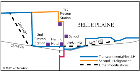
- Belle Plaine: 21st Street, 7th Avenue, 19th Street, 8th Avenue, Main Street, 13th Street, 13th Avenue, 15th Street. See "Along the Route" section.
- The only section of Belle Plaine's entire 1921 Lincoln Highway paving project still in the primary system after 1928 was east of the cemetery.
- Belle Plaine to west of Cedar Rapids: E66, V40, US 30 (pre-2020s four-lane on section line; westbound lanes, US 218 to Atkins corner; eastbound lanes, Atkins corner to Morgan Bridge Road)
- As late as 1925, some Benton County residents considered a petition to move the Lincoln Highway onto E44 ("straight west from Newhall") although this would've complicated the route in Tama County. (Traer Star-Clipper, June 26)
- Cedar Rapids: 16th Avenue SW, Johnson Avenue, A Avenue NW, 9th Street NW, 2nd Avenue SW, 10th Street SE, Mount Vernon Road, Lincoln Heights Drive SE, Mount Vernon Road
- The IA 100 bypass cut 16th Avenue SW at 80th Street SW. A piece of pre-1985 road exists to the west.
- The Lincoln Highway switched from 1st Avenue to 2nd Avenue in 1916, and appears to have stayed that way until 1931 contrary to state maps.
- There was a short-lived proposal to shift by-then-US-30 to the northwest side of Cedar Rapids. According to the March 24, 1936, Cedar Rapids Gazette, the new route would create a new diagonal from the intersection of B Avenue and 17th Street NW to the intersection of F Avenue and 13th Street NW, then use F Avenue and its bridge across the Cedar River. From there, it would go northeast on B Avenue (including a new viaduct and road from 3rd to 8th streets NE) to 8th Street NE, southeast on 8th Street NE, and resume its previous route on 8th Avenue SE to Mount Vernon Road. Two years later, however, a new US 30 bypassed part of downtown to the south via 16th Avenue NW and 8th Avenue SE across the Cedar River. Present I-380 from the Cedar River to 8th Street is just south of the never-built route.
- Based on an entry in an old sheet in "100 Years of Concrete Paving in Iowa", the Lincoln Heights Drive "hump" was straightened in 1931.
- See also: Jason Hancock's Highways of Cedar Rapids and my investigation on the Lincoln Highway in Cedar Rapids.
- Cedar Rapids to Clarence: E48, Old Lincoln Highway (bridge across railroad), E48/1st Street in Mount Vernon, Lisbon Road, Main Street in Lisbon, US 30, Old Lincoln Highway through Mechanicsville, US 30
- Including a short stairstep that used a vacated strip behind Community Bible Church, Abbe Hills Road (¼ mile), and Museum Road (¼ mile) just northwest of Abbe Creek School (1844). This changed to the present diagonal in conjunction with opening of the Mount Vernon Road cutoff between Cedar Rapids and Mount Vernon on October 1, 1921.
- "The Friendly Road. You are to go the road which you see to be the straight one, carrying whatever you find is given you to carry, as well and as stoutly as you can, without making faces, or calling people to come and look at you." — Mount Vernon Hawk-Eye, September 15, 1921, in the inspirational-quote box, coincidentally (or not) near a story about the imminent opening of the cutoff above.
- The C&NW (now UP) overpass right by the Cornell College football field was bypassed in 1936. The brick south of the old bridge is original.
- Segment between Adams and Charles avenues broken by Mount Vernon/Lisbon bypass in 2019.
- In 1916, Lisbon was the one-third-point from New York to San Francisco on the Lincoln Highway.
- Clarence to Lowden: X64, 150th Street, Union Avenue, 155th Street, Y24, Lincoln Highway
- 155th Street at US 30 had its bridge closed in 2017.
- Lowden: 3rd Street, Jefferson Avenue, 1st Street, Lincoln Highway, vacated extension to county line
- Cedar/Clinton line to Calamus: Cedar-Clinton Road (¼ mile), vacated roads aligned with 225th Street and 105th Avenue, Lincoln Highway, 230th Street, 120th Avenue (and vacated extension south), 233rd Street (and vacated extension west), Y32, Lincoln Highway but with a more winding route in the Syracuse Wildlife Management area, US 30
- An ISHC document with final approval September 21, 1921, contradicts a nearly identical but undated (probably 1922) document and a story in the next day's Clinton Advertiser. The former (FAP 125) kept the original Lincoln Highway route on 233rd Street/Park Road and Y32/Toronto Street in Wheatland. The latter (FAP 147) had a change "one mile west of Wheatland, commencing at the shooting park and proceeding in a northwesterly direction, cutting out two right-angle turns." It's this line, originally named Chestnut Street in Wheatland, that is Lincoln Way today.
- On the east side of Wheatland, there was half a block of Bennett Street and then a vacated extension of the alley eastward; this changed in 1922. Paving in the city was completed in late August.
- Two hundred Clinton County farmers were not on board with the good roads movement. Among their goals, reported the Wheatland Gazette on October 4, 1922: "Resolved that the highway commission be abolished."
- The first route, until 1922, included the driveway north of 154th Avenue and squared-off corner at the golf course going straight south to the intersection of present 30 and 158th Street. The Calamus Creek bridge, now closed, was built in 1921 to skip that but paving was not completed until two summers later (Clinton Advertiser, June 11, 1923).
- The present "old Highway 30" route was not completed until 1931, when bridges were built across the Wapsi and overflow. At least part of the abandoned concrete, in use for only nine years, appears to remain in an inaccessible area.
- Calamus to De Witt (1913-20) (probably): Davenport, Spring, 2nd, Main or Grove, and 5th Streets in Calamus; 245th Street, Y52, 250th Street, 220th Avenue, 245th Street; Sunnyside, Jensen, Fulton, and Smith streets in Grand Mound; Prairie Lane/243rd Street, 237th Avenue, US 30
- This route does not appear in Huebinger, the 1912 or 1914 county maps, or early state maps. However, it's the established Lincoln Highway route. The 2011 Heritage Byway uses Grove, but other sources say Main, which just glances the corner of the business block on 2nd.
- BUT: An item in the Wheatland Gazette on September 12, 1917, chided a writer from the Durant Star for bad-mouthing the road north of the railroad, saying that was not the current Lincoln Highway. "Follow the present route of the Highway, which lies south of the railroad, and you will tender your apology to the Highway."
- AND: An item in the Wheatland Gazette on November 3, 1920, about the erection of steel Lincoln Highway markers, said a change in the highway "brings the road straight through on the north edge of Calamus" with no railroad crossings.
- That would explain why paving plans from 1922 clearly mark "Present Road" on Smith Street on the north side of Grand Mound. Most likely, for approximately two years, the Lincoln Highway followed Smith, DeWitt, and East streets and headed east on Prairie Lane.
- Calamus to De Witt (1920-present): US 30, except in Grand Mound as noted above
- De Witt to US 67: 11th Street, 10th Street, 5th Avenue, 11th Street, Old Highway 30, 245th Street, Z24, US 30 (westbound lanes)
- The one-block jog at the city park lasted until 1950!
- The gentle curve at the extinct map dot of Malone, where old and new 30 meet, was built in 1929 (De Witt Observer, November 7). The eastern half is gone except inasmuch it's the northeast boundary of Killdeer County Park (a fill pond).
- Where the four-lane overlaps the original route, the westbound lanes have more up-and-down than the eastbound, a key to discerning that that is the original road.
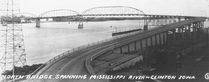
- US 67 to state line (Clinton): Vacated road across Mill Creek, Harrison Drive, 19th Street, Bluff Boulevard, 5th Avenue S, 2nd Street, and Main Avenue to the Lyons-Fulton Bridge.
- A trace of the vacated roadbed can be seen in a weirdly positioned parking lot between the EconoLodge and Country Inn and Suites.
- The old concrete on 27th Avenue S (1930) did not start as part of US 30, but IA 99, extended along Camanche Avenue and 4th Street.
- "It was stated at the Chamber of Commerce meeting yesterday that some of the Lincoln highway traffic turns west on Fourth instead of Fifth avenue, and the statement brought up the question of adequate marking." (Clinton Advertiser, September 5, 1923) Fifth Avenue is Clinton's original business district.
- At the intersection of 2nd Street and 8th Avenue S, a driver could go east across a privately owned toll bridge that went diagonally across the river and then south of the railroad starting at Little Rock Island. A new bridge in 1956 left Clinton at the same place, and US 30 was routed onto it.
- In 1931, 30 was relocated to Manufacturing Drive from its intersection with Bluff southwestward.
- In 1935, based on interpretation of state maps, 30 may have been taken off Manufacturing/Bluff and put on Camanche, replacing 99 through the city. The old route remained a "cutoff", at least unofficially.
- In approximately 1940, the portion of present US 30 between US 67 and South 14th Street was paved. Ironically, this means that the part of present 30 west of South 14th, the only part in the city named Lincoln Way, is the newest iteration and postdated the Lincoln Highway by 12 years!
- The Liberty Square project, completed in 2009, created a pair of one-ways for US 30/67 between South 14th and South 4th streets.
- Related routes: The Lincoln Highway is a special
highway and its legacy is worth some extra notes.
- Signed highways other than US 30 that contain(ed) part of original IA 6, west to east:
- US 6: Broadway in Council Bluffs, from about 38th to 8th streets, turned over in 2016, and 8th Street to Kimball Avenue, bypassed in 1984. Many other major highways through Council Bluffs used Broadway at one point or another.
- Technically, one tiny part remains in the state system: Kanesville Boulevard from Kimball Avenue to the North Broadway intersection, two blocks between Council Bluffs' two hospitals, is part of unsigned IA 906, which is old 6 between old IA 192 and I-80.
- IA 183: Council Bluffs to Missouri Valley, decommissioned in 2003
- IA 37: Three blocks in Dunlap shared with present 30 in a wrong-way multiplex, and then six more blocks through downtown to 12th Street, about ¾ mile total
- IA 25 (II): 1 mile, from State Street in Scranton to its north end
- IA 144: About ¾ mile between E53 and the intersection of Main and 9th streets in Grand Junction
- IA 17 (II): For the first LH/IA 6 route, less than half a mile between 205th and 210th streets that will be lost in 2022; for paved US 30, the east-west mile that will be lost in 2022, too
- US 69: Half a mile of Lincoln Way remains under state control.
- IA 330 (II): Original route from US 30 to downtown Marshalltown (1948-89); today, about ¼ mile between the E41 and S75 intersections
- IA 64 (II): From 1936 to 1969, IA 64 overlapped US 30 from the 30/330 intersection in Marshall County to Cedar Rapids, so technically all changes in that period apply to it.
- IA 146: 2 miles from old 30 at Le Grand to E49
- IA 212: Tama County side of Bohemian Alps/Belle Plaine cutoff in 1937
- Then, when 212 was truncated in 1980, 422 feet of road between the Tama/Benton county line and IA 21 became IA 940 (II).
- IA 247: Spur to Chelsea; 30 had only been paved for three years before a cutoff was built
- IA 131 (II): Benton County side of Bohemian Alps/Belle Plaine cutoff in 1937
- IA 94 (I) and IA 150 (IV), which at different times were assigned to the Mount Vernon Road diagonal
- US 67: 2nd Street in Clinton, about 2.2 miles
- IA 136: From US 67 across the Mississippi River on the old and new Lyons-Fulton bridges
- Signed highways closely related, but not IA 6's route:
- IA 133 (II): Spur to Nevada after 30 was rerouted in 1964
- IA 135 (I): Spur into Le Grand on Main Street
- IA 135 (II): Spur to Montour after 30 was rerouted in 1954
- Unsigned:
- IA 431 (II): Old 30 just west of Le Grand bypassed in 2004
- IA 922 (III): Business US 151 in Cedar Rapids (relevant segment: 1st Avenue from 9th Street NW to 10th Street SE)
- IA 930: Old 30 from Ogden to IA 330, although not all of this route carried the 930 designation at any given time. This designation officially remains between the Lincoln Way exit and the Boone/Story county line.
- Four-lane construction eventually freed up some 60 miles of the Lincoln Highway in a continuous strip. Throw in 11 more miles with the Marshalltown cutoff of 1947.
- IA 941 (II), old US 30/218 on 16th Avenue SW and 6th Street SW, although the only segment overlapping with IA 6 was west of the now-dead-end of Johnson Avenue
- IA 948 (I), old US 30 through De Witt
- IA 974, the Lincoln Highway diagonal northwest of Mount Vernon including the Seedling Mile
WEST End: Nebraska state line (Missouri
River/Ak-Sar-Ben Bridge), Council Bluffs
IA/Omaha NE, Pottawattamie County IA/Douglas County NE
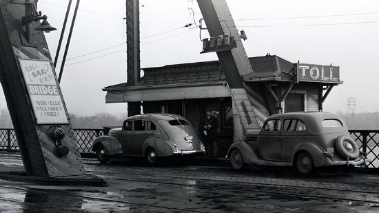
Library of Congress photo (1938)
Along the route
It's
Good Night for Honey Creek Hill
"Honey Creek Hill," on the Lincoln Highway twelve miles north of Council
Bluffs, since Pioneer Days has lain as a heavy dread for miles upon all
who approached it from either side. Millions and millions of tons of
traffic have toiled up a mile and a quarter of this incline with all its
kinks and turns only to be confronted when worn and breathless in the
last quarter with an almost impossible fifteen percent grade. … The
relocation will cut 80 feet off the climb, eliminating kinks and turns
and the minimum grade will be 6 percent, involving the removal of 75,000
cubic yards of dirt at a total cost of $45,000."
— Iowa Highway Commission Service
Bulletin, January 1921
Numerous changes in the
Lincoln Highway are being made in Harrison county this season,
especially between Logan and Missouri Valley. Work has also commenced on
the changes in the road between Logan and Woodbine. The changes are
going to make a dandy road, but it is mighty tough on a lot of farms, as
in some places the new road runs cornerwise through good ones.
— Woodbine Twiner via Denison
Bulletin Herald, September 8, 1920
Work is nearly finished on
the change in the Lincoln Highway about four miles east of town where
the road is to swing around in one big curve instead of having the
numerous short turns as it now has just this side of the Buttrick creek
bridge. This approach to the bridge has always been rather dangerous, as
there is a sharp curve which shuts off the view just this side of the
structure, but now this will be changed so that there will be an open
approach from the south. This change is being made preparatory to paving
the highway.
— Jefferson Bee, June 23, 1920
One of the finest
ornaments and markers along the route of the Lincoln Highway in this
vicinity has been erected by George Gregory at the southwest corner of
his farm northwest of Ralston in the shape of a cement corner post,
which has a five-foot frontage on the south side and the same on the
west. The post is fourteen inches thick and four and one-half feet high
and is marked in plain letters "Lincoln Highway". It is not on a
suitable corner post, but an improvement to the scenery along the
greatest road across the American continent. Such enterprise is very
commendable.
— Scranton Journal via Carroll
Times and Carroll Sentinel, April 2, 1914
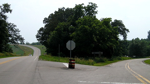
Facing west on Lincoln Highway (7/7/13)
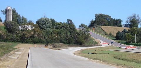
After construction of the Marshalltown diagonal, this is where US 30 split from IA 64. Now, to the right is E41, and to the left is IA 330. Turn around from this spot and you will see the 330/S75 intersection, where 330 has turned north since 1989 but the Lincoln Highway keeps going into Marshalltown.
Facing east on 30 (9/24/10)
This photo, taken shortly before completion of the Tama bypass, shows the Lincoln Highway on the right. The farmstead straight ahead was obliterated about a decade later to make room for a new four-lane US 30, which does not follow the Lincoln on the section line but instead runs just north of it.
East side of Mechanicsville (7/6/13)

15 miles Clinton
Co. paving is completed
CLINTON, Sept. 14 — Fifteen miles of Clinton county pavement on the
Lincoln highway has been completed and will soon be open to traffic.
Three miles of newly constructed road now remains to be paved. It is
expected the entire eighteen miles to Unity Corners near Calamus will be
open to traffic next month.
Sept. 28 the Clinton county board of supervisors will open bids for the
paving of the west end of the county, completing a paved road on the
Lincoln way across the county.
Cedar Rapids Evening Gazette, September 14, 1921
EAST End: Illinois state line (Mississippi River/Lyons-Fulton Bridge), Clinton IA/Fulton IL, Clinton County IA/Whiteside County IL
I'm a zillion percent confident about this being an endpoint. :-)
© Iowa Department of Transportation. All rights reserved.
Facing east on Main Avenue (7/6/13)
Here, the Lincoln Highway started on the bridge grade with a giant dogleg, heading south for two blocks before going east across the river.
Facing west (9/1/09)
The berm is behind the camera. This is about where drivers would reach ground level.
Page created 6/4/20; last updated 10/26/22