
(July 1, 1920-October 16, 1926)
- In 1920, they knew it as: The Burlington and Muscatine Road, Great White Way (Grandview to Davenport), Davenport-Maquoketa-Dubuque Road, East Iowa Scenic Trail (Dubuque to Calmar) (11 counties)
- We know it as: US 61, US 52, IA 9, and IA 139
- After 1924, US 52 north of Decorah
- Let's get granular:
- Missouri state line to US 61/218 split: Chicago, Burlington & Quincy Railroad bridge, road on edge of car graveyard, more jagged road where the abandoned Valley Drive is today, US 136, Iowa Street, California Avenue, US 136 (formerly named Reid Street west of Sage Creek), US 218, 243rd Avenue, US 61
- This is very close to the southernmost point in Iowa. For more on that and the abandoned concrete near the river, see the bottom of the Business US 61 (Keokuk) page.
- With a vacated road between the present 61/218 junction and Argyle Road on the west side of the then-Keokuk & North Western Railroad, now more or less the southbound lanes of 61/218
- With a vacated road that was a little straighter north of 242nd Avenue before angling northeast
- With a T intersection in the middle of Section 16, north of the present 61/218 split, where a left turn went toward Donnellson and a right turn went east ¼ mile, north ¼ mile, east another ¼ mile, then into Montrose
- The T was reconfigured to the intersection that would serve as the south end of US 161 in 1922. Notably, this did not make US 61 the through route, and that would remain the case until 2001.
- US 61/218 split to Fort Madison: IA 404, Mississippi River Road, US 61, 251st Avenue with southward and northward extensions paralleling the railroad, US 61 (northbound lanes or close), X23/263rd Avenue (with squared-off corner at 240th Street for one year)
- At the section corner southwest of Montrose, today the driveway to Agrineed, 20 used that driveway then went east to the corner of the city limits (which you can see today in the timber layout) for the first year.
- There's a bit of abandoned concrete in the southeast corner of the present 61/X23 intersection.
- Fort Madison: Business US 61, 48th Street, Avenue L, 18th Street, Avenue E or Avenue H-2nd Street-Avenue G*, 1st Street, Business US 61, 201st Street (dead end at northeast end of bypass)
- The 1912 Huebinger and 1914 Lee County maps give a strong vibe that IA 2 and IA 20 were on separate routes coming into Fort Madison until 1925, but every state map has them joining west of Fort Madison, and a 1921 construction document makes the joint routing clear.
- In western Fort Madison, the move to Avenue O between 35th and 48th streets happened in 1937.
- *A 1934 construction document puts US 61 on Avenue E in eastern Fort Madison. The cover of 1952 construction documents look like 61 is routed on 20th Street and E but a couple individual blueprints mark "US 61" on Avenue H, like it was until the bypass was built. Any clarifications would be appreciated.
- A little jog in the route at 6th Street was not ironed out until the early 1950s, lending credence to the E Avenue route.
- A construction project near the BNSF railroad bridge over the Mississippi River in 2020 found artifacts from "what may have been the first European settlement site in Iowa," the remains of Old Fort Madison. The fort was built in 1808 and abandoned in 1813. (Although Julien Dubuque was in Iowa first, the land that became the city of Dubuque wasn't open for settlement until 1833.) This project ripped up the entire roadbed on Avenue H, built in 1952 and expanded to four lanes from brick pavement, barely missing the Sheaffer pen factory. (The factory closed in 2008; the museum closed in 2018.)
- The original route ran right beside the walls of Fort Madison Penitentiary until 1952, when it was moved a block west. Access from state-maintained roads to state facilities is important, but ... just over the wall?
- Fort Madison to Burlington: US 61 but with the following:
- 345th Avenue, Lost Creek Road, and 354th Avenue
- A vacated road to the north of present 61 in the area of the intersection with IA 16, meeting that road about where 16 turns southeast today and then going east on the north side of the tree line
- The 1914 Lee County map has the first Skunk River crossing north of the CB&Q, where US 61 later goes; the 1914 Des Moines County map has a strip south of the railroad, of which only scraps remain.
- Burlington area: Old Highway 61, X62, Summer Avenue, Maple Street, Central Avenue, Osborn Street, Sunnyside Avenue, Memorial Park Road
- Burlington to Muscatine: US 61, J Avenue, Main Street in Wapello, X99, G62, I Avenue, Main and Jackson streets in Grandview, pieces of old 61 between IA 92 and 170th Street, US 61
- From the north side of Burlington to Mediapolis, the straight line that has served since 1920 as IA 20 and US 61 will be lost with the four-lane that will occasionally deviate from it. The same thing eventually will happen with the road from Mediapolis to Grandview.
- US 61 in Louisa County was paved in 1932, which completely changed the route between Wapello and Grandview.
- North of the Letts corner (former IA 305), the four-lane hews pretty close to the original, with the exception of a squared-off corner at 275th Street and the left-behind frontage roads now named Fruitland Road and Grandview Avenue.
- Muscatine: Present Business US 61: Grandview Avenue, Green Street, Hershey Avenue, Mississippi Drive (formerly Front Street), Mulberry Street, 2nd Street, Park Avenue
- Muscatine's Main Street is both short and in an odd place (near that "notch" in the highway route). Was that a different settlement at first?
- The position of the northbound sign gantry on IA 38 at US 61, at Taco Bell, is where 20 and 38 split.
- Muscatine to west Davenport (1920-24): US 61, frontage road between New Era Road and 180th Street, Y14, 172nd Street, US 61, 170th Street, US 61, 160th Street (and southwest extension to Tucker Avenue), Martz Lane, US 61, Y26, 150th Street, Oak Lane, Mayne Street and Burnside Lane (dead end) in Blue Grass, US 61, 140th Street Place just west of I-280, Business US 61, Ricker Hill Road
- Oak Lane before being realigned for the US 61 exit, straight north from the gas station to Telegraph Road.
- What about that little stub of Blue Grass Road, as in the road to Blue Grass, near the IA 22/Business 61 interchange? It's an early addition (likely 1925, when it was paved) but not original, and was in use until 1957.
- Muscatine to west Davenport (1924-26): IA 22, Midway Beach Road and vacated extension, IA 22, Nobis Drive, IA 22
- This project, one of if not the first significant roads purposely built and paved for the primary system after its creation, had a working number of IA 200 but instead IA 20 was taken off the overlap with IA 2.
- The semicircle around Midway Road came in the 1990s when a spur railroad line was built to a mining area.
- Davenport: As researched by Jason Hancock and on the 1925 state map: Rockingham Road, Clark Street, Telegraph Road, 3rd Street, Pine Street, 4th Street, Main Street, Lombard Street, Brady Street, and the Brady Street segment north of I-80
- The intersection of 4th and Main is three blocks west of the Scott County Courthouse.
- Davenport to IA 136: Y68 (old IA 956), starting where it forks northeast while 61 forks northwest, Elmwood Road/234th Street on the north side of De Witt, Y68, US 61
- Including 184th Avenue north of F33 that's now a driveway.
- Including the left-behind frontage roads, Main Street in Welton, and old 61 from Y60 to 140th Street
- IA 136 to Fulton: Old 61 starting at the 61 Drive-In Theatre, 22nd Street and the entrance to Horseshoe Pond County Park with a closed but still-intact bridge over Prairie Creek, Main Street in Maquoketa, angled road from Grove Street across the Maquoketa River, Hurstville Road, Esgate Road, 182nd Avenue (dead end at North Fork Maquoketa River, bridge still intact)
- Fulton: 134th Street, 187th Avenue, 138th Street, 189th Avenue (for one year; the curving obvious "old 61" came in 1921)
- Fulton to Dubuque: US 61 and frontage roads, along with: 196th Street and extension south, vacated road between 61 and 215th Street, 183rd Avenue, connector south of 275th Street, 194th Avenue, 183rd Avenue again, Main Street in Zwingle, Heartland Lane (double-dead-end), Airview Drive and northwestward extension to Cycle Club Lane, Elmwood Drive
- 199th Avenue north of 175th Street is from the 1921 smoothing-out of the route in Jackson County. But, in an early-alignment hint, 196th follows a quarter-section line and dead-ends at a cemetery.
- Four-lane 61/151 where the new Southwest Connector exit has been built is on top of the original route.
- Dubuque: Key West Drive, Rockdale Road, US 61/151, Locust Street, Loras Boulevard, Jackson Street, ???, Central Avenue, US 52
- US 55 moved from Jackson to Central in September 1932. The map accompanying the IHC minutes shows the route using Jackson at least to 25th Street, so the two-block jog had to be north of that, but I have no way of knowing where.
- North Dubuque/Sageville: Sageville Road, with an extension to Walking Way
- Before 1932, the railroad crossing (now Heritage Trail) was closer to Deere Street and the road north, on the east side of the railroad, had 18-foot brick pavement. The gravel dead end at the railroad today is the 1932 version. US 52 was relocated here in 1976; the older brick may have been in place but inaccessible until the 1990s.
- The city limits of Sageville (PDF) follow the old alignment.
- In 1949, when the bridge over the Little Maquoketa River was being replaced, there was a "Future Line" survey that would have crossed the Little Maq near Thompson Mill Road and go straight west, taking out the semicircle at Sageville. But it never happened, and that semicircle exists to this day.
- Dubuque to Luxemburg: US 52 IA 3, with plenty of nips and tucks throughout the years, right up to a project in 2019-21
- Including a more angled turn at Leiser Lane (fixed in 1932), and St. Joseph's Drive through Rickardsville (bypassed in 1926)
- 1st Street in Luxemburg was built as a curve in 1930, but it hasn't been part of the official route for quite a while.
- Luxemburg to Guttenberg: US 52, Clayton Road, a scar heading north visible in aerial photos and the forest to Graham Road, Graham Road, Main Street in Millville, a vacated crossing of the Turkey River at the Bootleggers River Tavern parking lot, another scar in the trees west of present US 52, Nest Avenue, US 52, abandoned pavement near the River Ridge Road intersection, C43/Jolly Ridge Road, another scar in the trees northward, and an almost-switchback at the small creek, rejoining present 52 on a driveway in an area Google Maps labels Kline Hunt Hollow
- That last part avoids river bluffs, but also misses what today is one of the most scenic parts of the Great River Road, with the Mississippi River Scenic Overlook.
- Guttenberg: Route is a partial black hole. Present 52 isn't the original. My best guess is Dekalb Street, River Park Drive, Haydn Street, 2nd Street, Kosciusko Street, X56, and a vacated arc that connects with Skyline Drive.
- Guttenberg to Postville: US 52, again a little more winding; US 18/52, also using Froelich Road and Fox Avenue; Main, Center, and Page streets in Monona; 115th Street, plus Burgess and Main streets in Luana; US 52
- From just south of IA 13 to the point where an abandoned connection to US 18 forks northeast, the route was west of the present alignment, running on the west side of the cemetery at Harness Road.
- Between Monona and Postville the pre-1926 route crossed the Chicago, Milwaukee & St. Paul Railroad (later the CMSP & Pacific) eight times; today there is only a crossing in Monona and an underpass west of Luana.
- Postville to Calmar: US 52, with the inclusion of Pole Line Road in the northeast corner of the 18/52 intersection, Military Road northwest of Castalia, and West Street, Broadway Street, and Middle Ossian Road
- Twelve railroad crossings between Postville and Calmar, making a total of 20 from Monona to Decorah!
- At the time of paving in 1928, there was a jog that used West Street and Fisher Avenue in Ossian.
- Calmar to Decorah: US 52/Maryville Street; North Street in Calmar and 240th Avenue (dead end); US 52; stairsteps from 200th Street to Town Line Road including 235th Street, 210th Street, Big Timber Road, and 222nd Avenue; Trout Run Trail starting where 52 turns north; Short Street in Decorah
- Short Street retained state-highway-era pavement south of IA 9. The street stub that met Short at Kerr Drive and ran behind the Fairfield Inn & Suites was how IA 20 originally changed direction, and then was how one got from northbound 52 to westbound 9. This stub was removed in 2016.
- Decorah to state line, 1920-24: IA 9, 240th Street (and extension along section line to about 285th Avenue), W14, County Street in Ridgeway, 307th Avenue, IA 9, vacated road north-northwest to the intersection of 285th Street and 328th Avenue, 328th Avenue, 290th Street, IA 9, and IA 139 with the following corners: 325th Street and 333rd Avenue, 324th Avenue and 347th Street, 313th Avenue and 360th Street
- Decorah to state line, 1924-26: Short Street, Mechanic Street, Water Street, and College Drive in Decorah; US 52; 211th Avenue; US 52; 236th Avenue through Burr Oak
- The latter deviations from 52 were bypassed ca. 1974.
- Related routes:
- IA 130 (I), which became IA 139 (II), as mentioned at top: Post-1924 route from Cresco to Harmony MN. These two and 404 were the only ones in this section signed.
- IA 404 (I) and IA 924 (formerly IA 998), spur to Montrose and old road north of Montrose
- IA 461, current Business 61 through Davenport
- IA 934 (I), Memorial Park Road on the north side of Burlington
- IA 946 (I), unsigned old US 18/52 between Luana and Monona
- IA 965 (I), bypassed segments of US 52 north of Decorah
- Segments bypassed during four-laning of US 61:
- IA 289 (II), curve west of Fort Madison after the IA 20 era
- IA 373 (II), two segments of US 61/IA 92 between the Louisa/Muscatine county line and the southwest part of Muscatine
- IA 421, two segments of old 61 between New Era Road and 180th Street northeast of Muscatine and also old 61 through Blue Grass
- IA 913, southwest of the present 61/X62 junction south of Burlington
- IA 954, old 61 between Maquoketa and IA 136
- IA 955, Key West Drive in Dubuque, dead-ended with Southwest Arterial project
- IA 956, old 61 from near the Davenport airport to north of De Witt
- IA 960 (I), Brady Street from near I-80 to where the 61 freeway crosses over it
- IA 960 (II), old 61/218 on their shared segment through Summitville
- IA 961 (III), old 61 in Wever
- IA 961 (IV), old 61 in Fort Madison between IA 2 and the north end of the bypass
- See also: Jason Hancock's Highways of Davenport and Bettendorf, Dubuque Highway Chronology
NORTH End (1): Minnesota state line, now IA 139 at line, Winneshiek County IA/Fillmore County MN
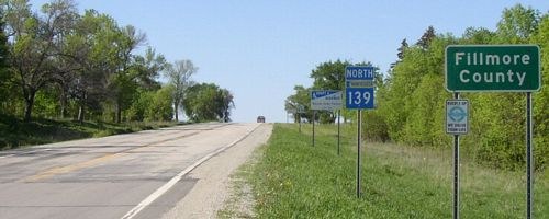
Facing north on 139 (5/18/04)
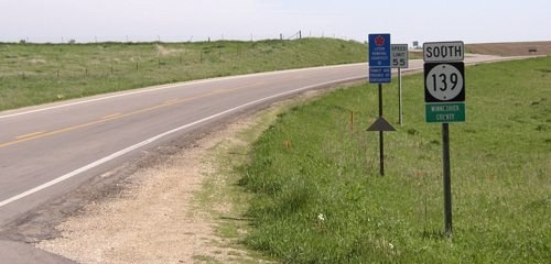
Facing south on 139 (5/18/04)
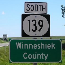
Facing south on 139 (7/25/16)
For more photos see the IA 139 page.
NORTH End (2): Minnesota state line, now near US 52, Prosper MN, Winneshiek County IA/Fillmore County MN
Facing north on 11 (5/19/04)
In 1924, the route was changed to go north of Decorah, in all likelihood to match MN 20. The 1922 Minnesota state map from the Minnesota Digital Library is the oldest online that includes highway numbers. Before 1924, the road came to this point, jogged east, then turned north. That was changed in 1928 to curve a bit east to the state line; in 1974 it was re-realigned to go straight. Unfortunately, aerial photos cut off right at the line, so I can't specify if Prosper was bypassed before the road was straightened at the line.
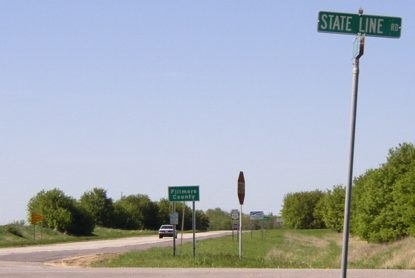
SOUTH End: Missouri state line (CB&Q Railroad bridge), Des Moines River, Keokuk, Lee County IA/Clark County MO
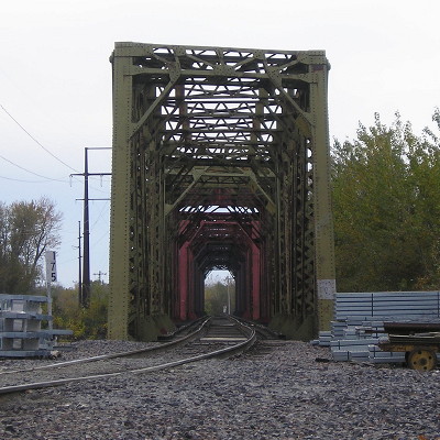
Facing southwest (11/4/19)
Or some sort of bridge pair on either side? Look below. This photo is taken from near the southernmost publicly accessible position in Iowa.
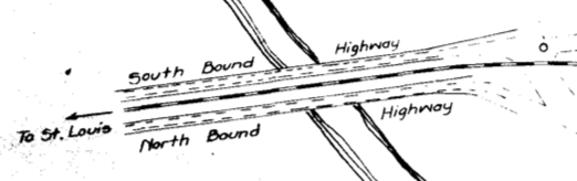
ROW document for US 61 near state line, approx. 1934
Page created 5/20/20; last updated 2/2/21