
(July 1, 1920-February 15, 1935)
- In 1920, they knew it as: Multiple auto trails. Every time the road hit a major town, the name changed: Calmar, Cresco, and Austin Pike; Cresco and New Hampton Road; Waterloo and New Hampton Road; Tama and Waterloo Highway; Montezuma and Waterloo Road; Oskaloosa and Montezuma Road; and then meandering on its lonesome south-southwestward (10 counties). I've also seen a reference to L.T.K. Trail for La Crosse, Tama and Kansas City ("Minnesota Trunk Highways," Good Roads, November 2, 1918)
- IA 40 and 59 are the most important routes with a number above 25, and numbered specifically because they are based on Minnesota.
- We know it as: IA 5, IA 137, and US 63
- From Oskaloosa north, the route was announced as an extension of US 63 in early December 1934. Contemporary news stories point to signs for US 63 coming two months later.
- Modern IA 5's turn back southwest after going southeast for so long betrays, or reveals, that in 1920 there were different numbers north and south of Albia.
- Let's get granular:
- State line to Centerville (1): 614th Street, 135th Avenue, 580th Street, 183rd Avenue, IA 5, 195th Avenue, J46, 217th Avenue
- Early county maps, but not the state map, are clear on this, going through the extinct map dot of Lexington.
- State line to Centerville (2): 141st Avenue, 600th Street, 150th Avenue, 590th Street, 153rd Avenue, 584th Street, IA 5, 195th Avenue, J46, 217th Avenue
- The latter route is the one that got curves added in 1929, to follow 141st Avenue, 594th Street, 155th Avenue, and 584th Street. However, it's unclear when one became the other.
- See this blog post about the highway south of and in Centerville.
- Centerville: Drake Avenue, IA 2/Maple Street (half-block), Haynes Avenue, Franklin Street, IA 5/18th Street, Haynes Avenue, Grant Street, St. Joseph's Drive/26th Street (partially vacated), St. Joseph's Drive/Old IA 5
- The continuation of Haynes Avenue northeast and east from its north-south line is a big giveaway of an old route... but a 1924 document digitized in 2021 revealed that Haynes north of Franklin did not exist until then.
- I am not 100% sure that 59 was using Haynes in 1920. There's an outside chance it could have gone west on Maple, north on Main through the courthouse square, then east on Franklin to 18th. I have no definitive proof it didn't use Haynes, though. IA 3 (I) went by the square for at least part of the 1920s.
- The Iowa Highway Commission Service Bulletin for July-August-September 1924 says there were "heavy excavations" on the north side "which resulted in the elimination of three right angle bends", although there were four turns in the area (Haynes/Franklin, Franklin/18th, 18th/Haynes, Grant/26th). This is when the Shamrock Lane diagonal was built.
- Centerville to Albia: IA 5, 465th Street, 233rd Avenue (and straight north), 230th Avenue, 458th Street, 233rd Avenue (vacated) (1920-22)/more 458th/240th Avenue (also vacated), IA 5, 440th Street, 244th Avenue/645th Avenue, IA 5, 644th Place, IA 5
- The switch from 244th Avenue (which no longer meets 440th) to what's now old IA 5 was made in 1928.
- The road through Moravia was bypassed in 1976.
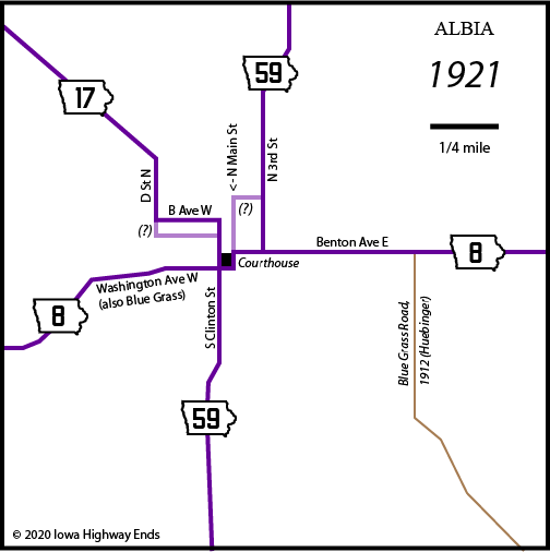
- Albia: Clinton Street, Benton Avenue, 3rd Street
- In 1939, it was moved to Clinton Street, 5th Avenue, and Main Street, and that's when the roads that meet at the current south end of IA 137 were built.
- The highway from the state line to Albia has carried four numbers: 59, 6, 60, and 5.
- IA 137, named the Buxton Road (north-south) and Chariton Road (diagonal), with half a mile of 654th Lane
- Vacated pre-1933 winding road starting at 721st Lane, following tree lines to the north of present 137, then north to where 112th Street has a southward dip, then a bit of 112th Street and a vacated road on the south side of the Des Moines River to a bridge connecting with Walnut Street in Eddyville
- Eddyville, being in southeast Iowa, was river-before-railroad, which is why the business district is where it is. A bridge to the south opened November 17, 1951, and was in use until December 22, 2005.
- Eddyville: Walnut and 3rd streets, Palmes Avenue (pre-1997 IA 137, pre-2005 US 63)
- Note that this does not include the oldest existing concrete in Iowa, which is on the east side of Eddyville at the cemetery.
- Eddyville to Oskaloosa: Merino Avenue and 310th Street (straightened by 1926), US 63 (northbound lanes, more or less), Luminary Lane (dead end, has asphalt overlay on 1926 concrete, bypassed 1963)
- Oskaloosa to New Sharon: US 63, with the exception of the southernmost part of Lynndale Road and Lincoln Avenue 2 miles north of Oskaloosa, and squared-off corners at 170th Street and north
- The first improvement, in 1927, moved the RRX northward from the Lincoln Avenue crossing to 220th Street. The Lincoln Avenue concrete on the west side of the railroad was bypassed in 1936 with an overpass. Lynndale Road was bypassed in 1962. The straight line for 63 across the railroad was bent with a new overpass to the north in 2008.
- New Sharon to Montezuma: 135th Street-Parkin Avenue, later US 63-Niland Avenue-120th Street; US 63 with a squared-off corner at 110th Street, a bend at 530th Street to the west of the present route that goes right through a farmstead today, and squared-off roads southwest, south, and east of a roadside park
- The 1914 county map maddeningly marks neither route on the east-west portion. However, two separate construction documents mark 59 in the middle of Section 19, i.e. 135th Street. Today, this is the south side of the North Mahaska school complex and 135th no longer has a railroad crossing. (The fact IA 63 did not originally end in New Sharon lends credence to the junction being south of town instead of a mile north at IA 146's present south end.)
- Might we find a clue in 1857? In the Sixth General Assembly was "An Act to make the bridge across North Skunk River at Union Mills, a part of the public highway." But the definition of "public highway" is unclear. The Legislature of the time made laws for creating a lot of "state roads" that weren't highways 65 years later. (The law listed after that: Incorporation of the town of Centerville.)
- The Niland route is marked as "Present Road" in the grading plan for the present route of 63, so it might have changed in the early 1930s.
- Montezuma to Malcom: V13, 3rd Street, Main Street (1 block), 4th Street, 135th Street, 470th Avenue, 125th Street, 460th Avenue, US 63
- If it went through Malcom (say, 2nd-Main-4th-Washington streets?), it went straight through by 1922. That road, paved in 1935, remained largely intact until 2015.
- At US 6: Old 6 Road (1 mile), 110th Street (2 miles), and vacated road that would be 370th Avenue (1 mile)
- Although the 1919-21 maps show what you'd expect — 59 sharing old 6 for 3 miles then turning north — the county map indicates this didn't happen until late 1921, and the River to River went west one more mile before turning north.
- US 6 to Tama: US 63, with two quarter-mile steps at the Poweshiek/Tama line and E69 a mile north
- In 1926, this was changed to a half-mile at the county line and then north. In 1930, it was changed again to the present slope.
- A short road to a boat launch north of 340th Street partially uses an original curve in the road that connected to a bridge angled southwest-to-northeast geographically but perpendicular to the original channel of the Iowa River. That, too, was changed in 1930. The present bridge was built in 1977, and a strip of abandoned pavement is on the east side of 63 today.
- Tama-Toledo: US 63, State Street/Church Street, High Street, US 63
- Despite a 1915 map of Toledo calling "County Road" and "Church Street" by their current names, a 1916 map confirms the perhaps-old names seen in the Tama County Board of Supervisors minutes of March 31, 1922: Park Street and College Avenue.
- Yes, the place where the Tama and Toledo city limits meet is literally the separation of Church and State.
- On May 4, 1925, the Tama City Council changed the route because "State street is impractical on account of the inability to straighten the Johnston curve" between US 30 and the Iowa Juvenile Home. IA 59 was moved onto a block of 5th Street in Tama (with the Lincoln Highway) and McClellan/Broadway streets to the Tama County Courthouse, where it turned west two blocks on High and then north. (Toledo Chronicle-Democrat, May 7)
- The Iowa Juvenile Home opened in 1920 where Western/Leander Clark College had been, and was closed in 2014. Western College had started in Linn County, was relocated to Toledo in 1881, was renamed in 1906, and consolidated with Coe College in 1918. (Tama County History)
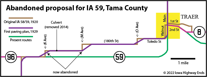
- In 1930, in conjunction with paving 59 through Tama County, the IHC moved 59 onto US 63's present route. This meant two miles of road "between" Tama and Toledo were bypassed three years after paving. (Traer Star-Clipper, February 21, 1930)
- Toledo to Waterloo: US 63, K Avenue (¼ mile), vacated road (2 miles), M Avenue (¼ mile), 180th Street, Walnut and 2nd streets in Traer, US 63, PP Avenue, 125th Street, QQ Avenue, US 63, IA 58, Wood and Washington streets in Hudson, Eldora Road (and dead-end Eldora Court)
- Waterloo: Shaulis Road, W 4th Street, Wellington Street, W 5th Street, Franklin Street, Logan Avenue
- Wellington Street is where, in Waterloo's modern street system, 4th and 5th streets have weird shifts where they become 5th and 6th streets.
- The corner of Franklin and Logan isn't a corner anymore; it's where US 63 starts/ends a one-way split. Logan between Franklin and Parker was dropped for a wider arterial route half a block east on Halloween 1963.
- Waterloo to Frederika: US 63, with present frontage roads to the west at Mount Vernon Road and east at the Black Hawk-Bremer county line, and a vacated strip at 200th Street
- Frederika area: C16, Midway Avenue, 118th Street, abandoned but still-existing bridge over the Wapsipinicon River, V5C
- Bremer/Chickasaw county line to Lime Springs: US 63, Business US 63, IA 24/Main Street, Pleasant Hill Avenue/Mission Avenue, US 63 including the bypassed strip (1970) at Our Lady of Lourdes Church, IA 9 (1 mile), Oak Avenue
- US 63 would have an east-west jog on New Hampton's Main Street until 1963.
- Lime Springs to state line: Miller, Main, Clark, and Jones streets; V36, Upper Mill Road, Mill Road, May Avenue, and 25th Street; an extension of Key Avenue on the south side of US 63 and opposite side of the railroad tracks, abandoned in the 1990s with a slight adjustment to 63; Park, Main (with a due-southeast extension), Minnesota, and River streets in Chester; vacated crossing of the Upper Iowa River at River Street and northwest extension to the half-section line; vacated road along the east side of the trees to the state line
- Related routes (all unsigned):
- IA 342 (II) and IA 437, bypassed segments of old US 63 and IA 137 in Eddyville
- IA 463, segment of old 63 near Frederika bypassed by four-lane
- IA 478, Linn Avenue from IA 24 to the old 63 curve (US 63, 1963-2002)
- IA 915 (II), Clinton Street and 5th Avenue in Albia, bypassed in 1995
- IA 941 (I) and IA 942 (I), old IA 5 through Moravia in Appanoose and Monroe counties, respectively
- IA 943 (IV), old 63 through Denver
- IA 987, old 63 between Hudson and IA 412
- IA 988 (I), old 63 on the south side of Hudson
NORTH End: Minnesota state line, now near US 63 at line, Howard County IA/Fillmore County MN
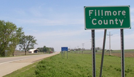
Facing north on 63 (5/19/04)
Originally, based on the design of early state maps, we thought 59 terminated in Chester. This turned out not to be the case. In fact, from the beginning 59 crossed into Minnesota, because the number came from MN 59.
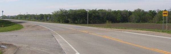
Facing south on 63 (5/19/04)
The crossing for IA 59 until it was paved in 1931 was a fraction of a mile east of this location, but this is the equivalent.
Along the route
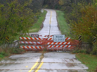
Facing south on 644th Place (10/18/20)
You can tell the 1930 concrete by the remaining curbs. A significant segment of IA 5 between Albia and Centerville was shifted half a mile west in 1975, and this mile-long segment is the only part where 5 was moved east. This 2010s closure of a small bridge severed the latter.
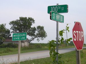
SOUTH End: Missouri state line, now 135th/141st St. at line, Appanoose County IA/Putnam County MO
Facing south on 59 (7/11/05)
Originally, 59 came south on 135th Avenue, east on 614th Street (Appanoose)/100th Street (Putnam), then turned south here. Later, at some point in the 1920s, the road was changed south of Cincinnati to be a little curvier and come straight down to the state line.
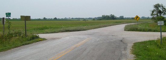
Facing north on 59 (7/11/05)
On the Missouri side, the piece of old 60 is paved as Route UU. This was the endpoint until 1951.
Page created 5/18/20; last updated 2/12/22