
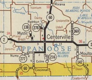
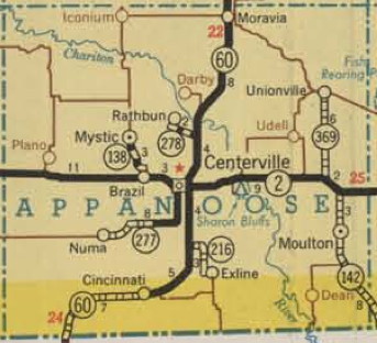
Appanoose County in the 1948 (left/top) and 1951 Iowa Highway Commission state maps. Notice the non-existence of Lake Rathbun. Drake Avenue is shown as the north-south piece of IA 277, but it actually belonged to IA 60, as you will see in the research below. (Also, the map dot of Brazil became the map dot of Sunshine, at the end of IA 138, but the name wasn’t changed until the next year.)
Appanoose County is going to take out a curve that was part of a state highway until the middle of the 20th century.
Drake Avenue, or 217th Avenue, runs a fraction of a mile west of IA 5. It was the original road for IA 60 (IA 6 until US 6 was brought into Iowa, then renumbered again in 1969). At the time, having that north-south road with a little curve meant traffic between Numa and Centerville could avoid a railroad crossing, and the curve is visible on late 1930s aerial photos. Now, the railroad is long gone, and the angle to the east-west road creates safety issues, so the county is going to make that a dead end and pave the north-south gravel road in April, the Centerville Daily Iowegian reports.
In a series of construction projects in the 1950s, IA 60 was moved to the east, following 18th Street in Centerville. A decade ago, tracking down specifics would have been extremely time-consuming, but thanks to the magic of microfilm scanning and OCR, it took a matter of hours to get what I wanted from the Iowegian archives.
Originally, 60 followed Drake Avenue and Haynes Avenue in Centerville. The modern street configuration is a clue; Haynes keeps its name even when the road turns east-west. On April 27, 1949 — a date learned a decade ago from research at the Iowa DOT library — 60 was realigned from Cincinnati to Green Street on the south edge of Centerville. It had gone north from Cincinnati to meet IA 277, the spur to Numa. The first state map to show this was the “1950 Alternate.”
But to get 60 onto 18th Street in Centerville, three different projects were undertaken. The first was to take out the brick paving and widen 18th south of IA 2; the second was to rebuild 18th between 2 and Haynes; and the last was angling the road northeast of Haynes away from what is now Shamrock Lane. These relocations were completed in September 1952, September 1956, and September 1957, respectively.
But where was 277’s end during this time? That’s a bit murky. The 1950A to 1953 maps show parallel lines, perhaps because the roads (Drake and 18th) were close enough that the mappers weren’t quite sure how to show the change. On June 2, 1948, before any relocation, the Iowegian reported:
When the new route is completed and finally paved the present highway which goes south from Centerville on Drake avenue by way of Streepyville to Cincinnati, will become county road and will be turned over to the Appanoose county engineer and board of supervisors.
That implies that Drake was going to be dropped from the system, and that is what handwritten notations on a county map show. I believe that in the 1949-52 time frame, it’s possible that 277 curved up to meet 60 at the intersection of Drake and Green, but not likely. The east-west road where the curve splits off was already part of the state system, as part of IA 216 to Exline, before that highway was paved on a different alignment.
In October 1952, most likely prompted by the relocation of 60 onto 18th Street south of 2, the Highway Commission set the east end of IA 277 at the southeast corner of Section 12. That is where J46 intersects 5 today, about half a mile east of the old curve that is going to be sealed off.
Five years later, the entirety of IA 277 was paved, including the replacement of 18-foot concrete with 24-foot concrete on the part that used to be IA 60. The spur to Numa was a victim of the Great Decommissioning of 1980.