
A road that never really existed...
Proposed NORTH End: Interchange, US 20, Waterloo, Black Hawk County
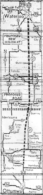
LEFT: Map from Des Moines Register, September 26, 1956; courtesy Jason Hancock/Des Moines Public Library archives
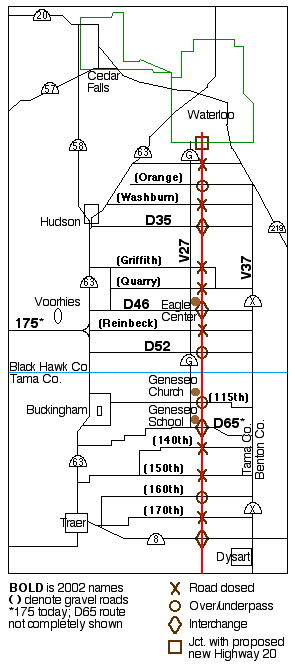
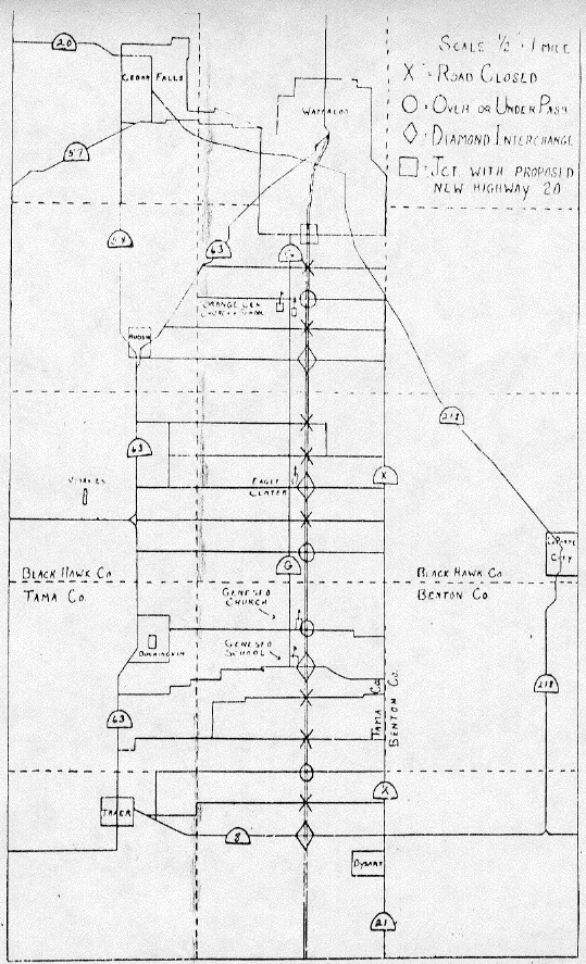
RIGHT: Map based on graphic on Page 1 of the Traer Star-Clipper, April 5, 1957; ORIGINAL MAP here
Planned interchanges correspond to today's paved roads, except today's D52 would not have access. This road does not show up on the maps in any way, shape or form until 1969 as part of IA 21. A Des Moines Tribune map of Dec. 12, 1968, depicting the Great Renumbering included a "402 to 21" marking that may have been the only public acknowledgement of the number.
The text under the original map says: "This map, prepared by Mrs. Florence Thomas, member of the Star-Clipper staff, from information compiled by our farm editor, Wendell Clampitt, shows the proposed superhighway in relationship to existing roads and community centers. It indicates what will be done, to the crossings, as unofficially disclosed. At the meeting at Orange school on March 27, the statement was made that nothing had yet been determined about road crossing. This was true to the extent that the whole plan depends on final approval by the federal bureau. Our information for this map came from Tama County Supervisor J.G. Powell, of Traer, and Black Hawk Supervisor Dave Keith, of Hudson. The head draftsman for the state highway commission had given them these plans for crossings, and the commission has asked each county board that they order the roads so indicated to be closed. (Actual closing, and building of passes, will take place if and when work on the second 24-ft. ribbon of the superhighway is done.) The hearing this Friday at the Hippodrome in Waterloo will determine the fate of the whole project."
If you want to go to Waterloo from points southwest, like Des Moines, today there are no guides for the shortest route. No BGS on I-80 eastbound mentions Waterloo, not at US 65, IA 14, US 63, or IA 21. Instead, they seem to want you to use I-380, out of the way. If Iowa 402 had been built, though, such a situation would not exist.
In the 1950s, the Eisenhower Interstate System wasn't even in its infancy yet. In fact, the same year the plan for this superhighway was made, 1957, was the year federal funds were first available for interstate construction.
In early April, the Waterloo Courier was abuzz with this plan. On April 3, a short article talked about an "interstate highway connecting link bypassing new Hwy. 20 south of Waterloo," the "new Hwy. 20" being the freeway that exists today. On the 5th, it said that the right-of-way would be bought for four lanes for the "interstate stub", but only two would be paved immediately. On the same day, the above map appeared in the Star-Clipper.
The April 7 story, under the headline "Interest Mounts in Highway Hearing," said the new 20 "ultimately would extend straight west to Webster City." "Ultimately," as we now know, means half a century, give or take five years. Four hundred attended the meeting, reported the Courier on the 12th, and were told the "superhighway" would initially go to IA 8, then down to US 30, and then US 6. It was thought that the new road would save 32 miles vs. traveling the same way on US 63.
If the road had continued straight south of 8 as planned, it would approximately bisect the road between Clutier and IA 21, split the difference between Elberon and Vining, be about two miles east of Chelsea, come very near Hartwick, and meet I-80 near or at where IA 21 intersects I-80 today, in its 201st mile. See the Register map.
By 1958, the proposed road had been given a number, 402. (No 1957 article mentioned any number.) As we know now, the land was bought and two lanes were indeed paved...and that's where progress stopped. You can see 402's north end, because it's the same as 21's.
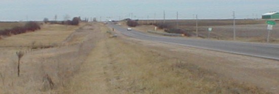
This is on IA 21 at the Waterloo city limits. Two fencerows are easily visible on the left, indicating where the DOT line first was and where it is now the standard distance from the two-lane. The land was bought, but the other two lanes were never built.
Within the next decade (and a half), something must have changed in their plans - in 1969, mentioned in the same breath (and Des Moines Tribune graphic) as the Great Renumbering, the completed two-lane portion was marked as the northernmost part of IA 21. That something would have been a plan to make a freeway connecting Waterloo and Cedar Rapids, I-380, which had its first segment opened in 1973. Although Black Hawk County was on the ball with the new interstate system, it would take 27 more years - 1984 - until Waterloo got a freeway. "Straight west to Webster City" didn't happen until 2003.
First planned SOUTH End: Interchange, IA 8, Tama County
Facing south on 402 (21)
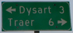
This is the LGS at the intersection today. (Obviously, it never did become an interchange.) This "end" also gives me an excuse to point out a goof that has lasted for five years:
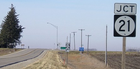
Facing west on 8, but heading north on 21
This is wrong because we're ON 21. This pole did not exist until the resurfacing of US 63 between Traer and Hudson in 1998. At that time, it had "Jct Detour 63" on it. When all the detour signs were taken down, someone got the bright idea to put something on this new pole. Whoops. This pole needs to be removed, ironic because a correct pole was removed in Traer (after I sent a letter to call attention to a different post-detour signage problem). See the west end of IA 8 for this other situation. This sign has now been incorrect for a decade.
Eventual proposed SOUTH Ends: I-80 ca. Exit 201, Poweshiek County; US 63, Mahaska/Keokuk county line
Although the Courier only mentioned extension of the highway from 8 to as-yet-unconstructed I-80, the Register map took it down to Ottumwa. See the top of this page. Notice the spurs to Clutier and Barnes City, and the gravel alignment of 21 between Victor and IA 85.
I have created a "Fictional Freeway Guide" for IA 402 based on the above maps and personal inference using Kurumi's SignMaker. The BGSs show the highways of that day based on Iowa sign standards. The fictional exit listing can be seen here.
All pictures by me: First, 1/9/02; second, 6/28/02; third, 11/20/06
Page created 5/22/02; last updated 1/13/07