

- In 1920, they knew it as: A route between Fulton and Bellevue, although it was changed at the last minute to go through Andrew instead
- We know it as: IA 62
- Let's get granular:
- Fulton alignment: 140th Street [& vacated], 150th Street, 216th Avenue, 167th Street
- Andrew alignment: IA 62; Main, Benton, and Johnson streets in Andrew; IA 62; 250th Avenue and 167th Street; IA 62 [slightly modified route from there to 189th Street]
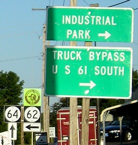
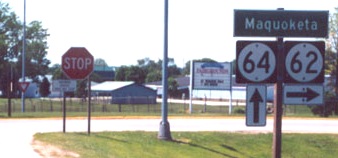
WEST End: Two-way stop*/T intersection, IA 64/Platt St., Maquoketa, Jackson County
*SB 62 and WB 64 stop; EB 64 doesn't
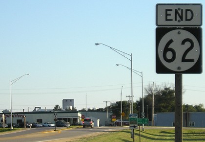
Facing south, but heading west, on 62 (8/31/07)
See down the page for more about the 1920 proto-version of IA 62.
Facing south, but heading west, on 62 (8/31/07)
Facing east on 64 (8/31/07)
Facing east on 64 (8/31/07)
Facing east on 64 (11/16/18 and 6/14/11)
Facing east on 64 (8/31/07)
The signs in this assembly are reverse what they usually are. In addition, eastbound traffic does not have to stop.
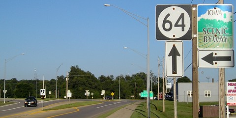
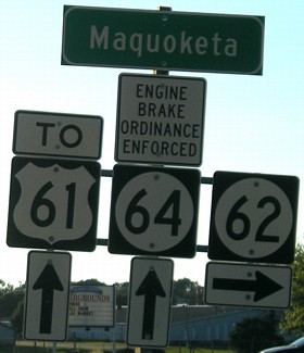
Facing west on 64 (8/31/07)
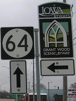
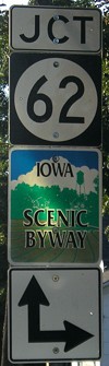
The vertical nature of the left sign may make you think that both 62 and the Scenic Byway are ahead and right, but only the byway is. That's fixed below.
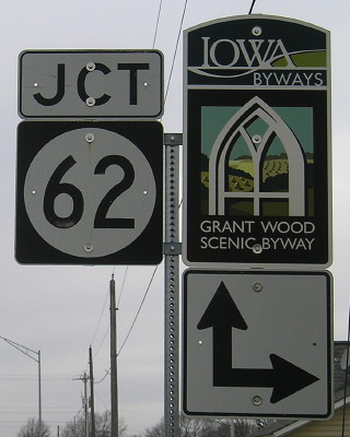
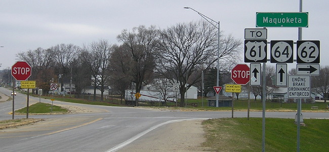
Facing west on 64 (11/16/18)
Facing west on 64 (5/26/02)
Photo by Jason Hancock
Facing west on 64 (8/31/07)
After 80 years of 61 being a mile west of 62's end, it seems odd to add a sign directing to it now. On the other hand, this gives us an assembly with a 61-62-64 sequence. (No connections with 63 and 65, though.)
Facing west on 64 (11/16/18)
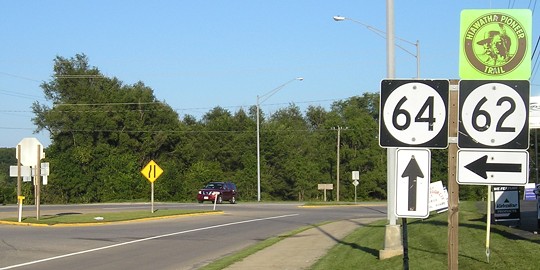
The left turn before the right turn that you can't see, basically where I'm standing, is the street that follows the section line and 62's post-1923 (or post-1930) starting point. Given the mid-century configuration (finalized 1958/paved 1961) of the intersection, I think we can fudge it enough to be ...
*Original Number, ALMOST Original End*
1920 WEST End (sort of): IA 20, equivalent to 140th Street at 189th Avenue, Fulton, Jackson County
In the 1919 and 1920 state maps, IA 62 is drawn as a straight diagonal from Fulton to Bellevue, and it's marginally so. However, in the Iowa Highway Commission minutes of July 8, 1920 — a week after the date we've settled on as the start of the primary system but a week before routes were painted across the state — the primary road (not referred to by number) was changed to run through Andrew to Maquoketa.
The future US 61 originally went through the unincorporated town of Fulton, on 138th Street and 189th Avenue. Present four-lane 61 breaks up the part where 140th Street, coming in from the northeast, would otherwise intersect 189th Avenue at 139th Street.
After that, the route of IA 62 has been remarkably unchanged. The change to the Maquoketa endpoint came possibly in 1923 (when the road east to Sabula was added to the state system) or at the latest 1930 (when IA 62 was graded). Since then, the road's exact location has shifted, for more gradual curves and your typical straightenings, but the general route closely adheres to a turn-of-the-century topo map. (The road south of Andrew existed, just not as 62 right away.)
In my perception there are only three places where, if you stood on the road in 1930, it would be hard/impossible to see the modern road: Just north of here, where a curve goes away from the section line; in Andrew itself, where the route originally used Main Street, Benton Street, and Johnson Street; and just northwest of Andrew, where it followed 250th Avenue (Y61) and 167th Street. Maybe the crossing of the Maquoketa River, where the Bridgeport Access is the original road.
1920s WEST End: IA 20, now Platt St. at Main St., Maquoketa, Jackson County
Future IA 64 wasn't created until 1923 (as IA 117), which means 62 had to go into Maquoketa. I doubt that 62's end was truncated to the east side of Maquoketa (the current endpoint) at that time, but don't know when that happened.
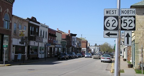
EAST End: Stop sign/T intersection, US 52/1st St., Bellevue, Jackson County
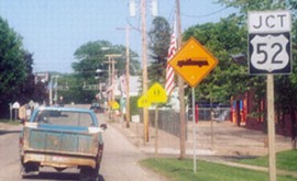
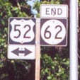
Facing east on 62 (5/26/02)
Photos by Jason Hancock
The left picture is three blocks before the right, which is at the very end. In this area, 52 is right alongside the Mississippi River.
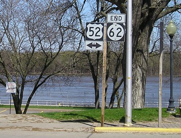
Wider view of end signage (4/18/06)
Facing northeast (4/18/06)
From the end of 62, you can enter a city parking lot right by the river. South of Dam No. 12, shown in the background, the river narrows considerably.
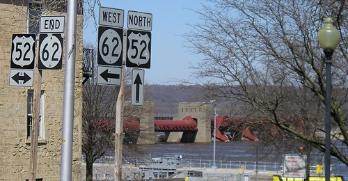
Facing north (9/27/15)
By 2015, the "End" sign set had moved to the other side of the road and onto the left side.
Facing north on 52 (4/18/06)
From start to finish as the crow flies, 62 covers about 11.5 miles east-west and 13 miles north-south, but is signed east-west.
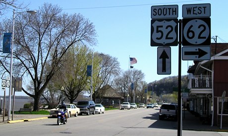
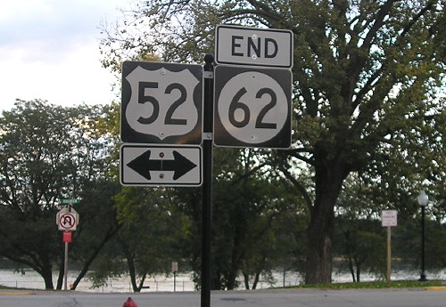
Facing south on 52 (4/18/06)
Both of the other assemblies are on the far left of this picture.
*Original Number, Original End*
Point of interest
Days were, when the people of Bellevue, famous old Mississippi River metropolis, didn't care whether they had a highway leading into town or not. That was in the "good old days" of boating, launching and logging on the Mississippi. The town grew out of, and was supported by, the river and was part and parcel of the daily stream of life that floating up and down the famous old "Father of Waters." Business and pleasure were inseparably bound up with the river. … Then came the railroad tracks and the train. The shriek of the locomotive mingled with the deep throated blasts of the Diamond Joe and other famous river craft. Then, some years later, the motor vehicle worked its way into the life of the community over roads that didn't deserve even the name of road. With the motor car came the demand for better roads. The modern highway builder came soon, sighted his instrument on the hills, and began cutting, forty feet deep in places, through the solid rock to build a highway through the bluffs to the flat above and beyond. When this road is finished, the "glory of the river and the days that were" will be gone. The river will be there to be looked at and enjoyed but not as such a vital part of the daily romance and business of life. Instead, and usurping its place, there will be the somewhat unromantic but very business-like and efficient Primary Road No. 62, from Maquoketa to Bellevue.
— Iowa State Highway Commission Service Bulletin cover, September 1923
Page created 7/21/02; last updated 3/18/20