 EAST
and
EAST
and  SOUTH
SOUTH
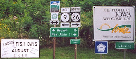
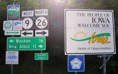
EAST End of 9: Wisconsin state line, Lansing, Allamakee County IA/Crawford County WI
SOUTH End of 26: T intersection, IA 9, Lansing, Allamakee County
"You start taking pictures around here, you'll never stop."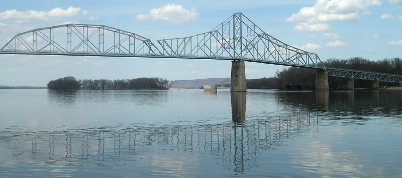
Facing north (4/17/15)
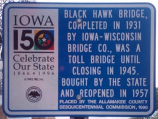
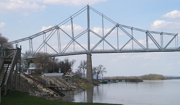
The Black Hawk Bridge is a striking piece of architecture and the key to this important intersection in Iowa, the northeasternmost endpoint that isn't a state line. The quote at top was shouted at me from a pickup driver, someone who clearly loves his corner (literally) of Iowa. More bridge pictures throughout and at the bottom of this page.
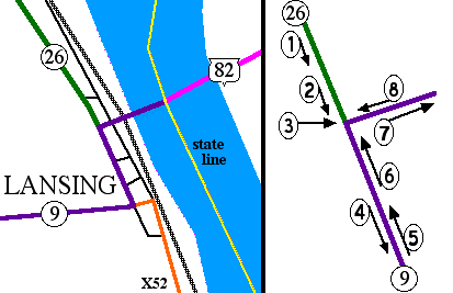
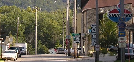
LEFT: Overview of Lansing, showing streets and RR tracks east of 9 and 26; RIGHT: Closeup of intersection
Technically, highways 9 and 26 do not end at the same place. Highways 9 and 26 now kinda-sorta end at the same place, but it depends on your point of view. The arrows in the graphic on the right indicate the direction of that picture. Working counterclockwise from eleven o'clock:
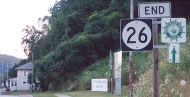
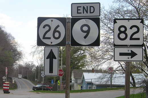
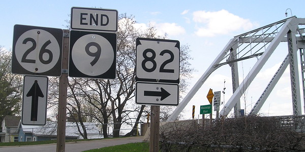
1a) Facing south on 26 (9/7/06)
As with the rest of the Great River Road, little "America's Byways" signs have been added recently, so Jason's "End" picture looks a little different. (Update: 2004 isn't "recently" anymore. I made my second trip to Lansing 9½ years after my first, and then by circumstance visited again within the calendar year, but the second time I was through, IA 26 was being detoured.)
1b) Facing south on 26 (4/17/15)
2a) Facing south on 26 (7/14/02)
Photo by Jason Hancock
The sign to the left of the "End 26" is below at picture 5.
2b) Facing south on 26 (4/17/15)
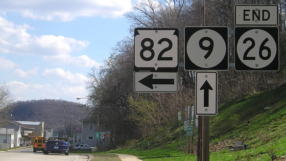
WI 82 shields were added to this intersection no later than mid-2012.
3) Facing southeast (9/7/06)
This was the best angle I could get to show how close the ends of the two highways are. Note that between 2002 and 2006, the "End 26" sign setup was changed.
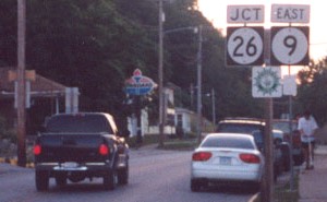
4a) Facing south, but heading west on 9 (4/17/15)
This is the first sign on IA 9 after the intersection. Just past it you see what's below.
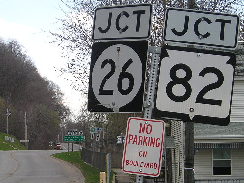
4b) Facing south, but heading west, on 9 (9/7/06)
This picture, after the intersection, shows IA 9's first
county road junction and an old Standard sign. Above the white car at
left is the assembly seen below.
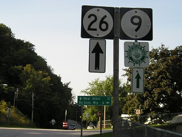
5a) Facing north, but heading east, on 9 (7/14/02)
Photo by Jason Hancock
5b) Facing north, but heading east, on 9 (4/17/15)
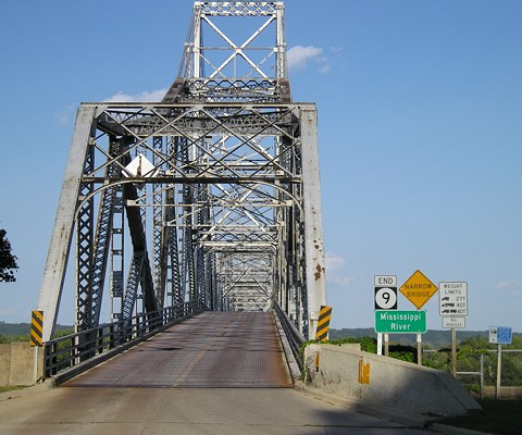
This picture is a little bigger to show not just that the last "East 9" is gone, but that there is now an "End 9" before the turn onto the bridge.
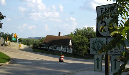
6a) Facing north, but heading east, on 9 (9/7/06)
The Great River Road shield should've been under the 26 shield instead of 9 because 9 is supposed to turn.
6a) Facing north, but heading east, on 9 (4/17/15)
WHY did the Iowa DOT "relocate" the end of IA 9 10 feet away from the bridge to the intersection? I have no idea. The state line runs through the river channel nearest the west shoreline here.
6b) Same signs, facing northeast with view of bridge (4/17/15)
7a) Facing east on 9 (9/7/06)
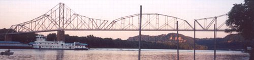
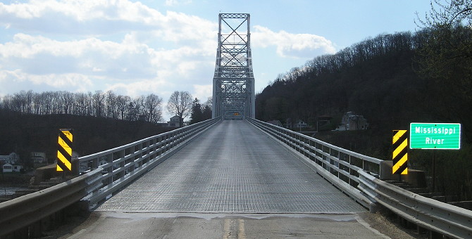
They certainly don't build bridges like this anymore - lots of superstructure, narrow lanes, steel deck, two sharp angles in the roadbed.
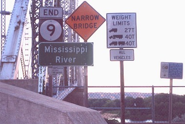
7b) Closeup of signs at right (7/14/02)
Photo by Jason Hancock
This sign is closer to its end than IA 2's is, because 2's is placed at the intersection before the bridge. Just north of here, the state border swings across the wide Mississippi to come a little closer to Iowa, at this point being in the actual middle of the river. This set of signs is 700 feet east of the intersection, or 2 1/3 football fields away. It is 2.7 miles to WI 35, on the other side of the river.
7c) Closeup of sign at far right (7/14/02)
Photo by Jason Hancock
Since the bridge was closed, for 12 years the end of 9 was quite literally right here. The next bridge north is US 14/old US 16/US 61 at La Crosse. The next bridge south is US 18 at Marquette.
Facing south (view of bridge) (7/14/02)
Photo by Jason Hancock
Facing southeast
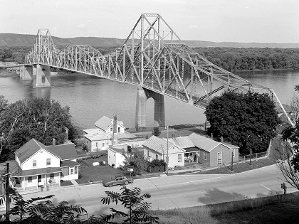
This picture, one of many of Iowa bridges currently in the Library of Congress archives, was taken in 1995. The road at the bottom of the picture is IA 26; the "End 26" is in the bottom right corner.
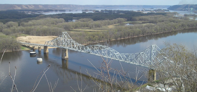
This early-spring picture is from Mount Hosmer Park lookout in Lansing, a beautiful scenic bluff view. (4/17/15)
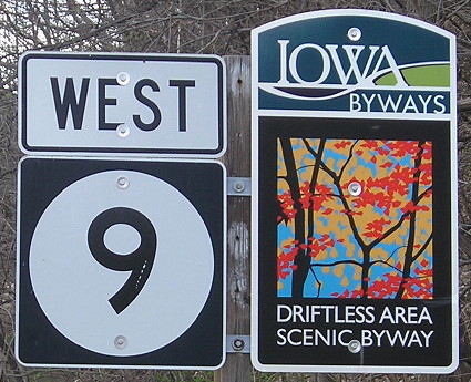
Facing west on WI 82 (4/17/15)
In the 1999 film The Straight Story, there is a scene of Alvin Straight (Richard Farnsworth) crossing this bridge on his way from Laurens, Iowa, into Wisconsin on a lawn mower to see his brother. It's a wonderful scene, including an aerial shot to showcase the beauty of both the bridge and the surrounding area. There's just one problem: He's filmed going the wrong way. The mower is shown crossing from Wisconsin into Iowa; the "Mississippi River" sign at right gets its own closeup. (If it had been filmed the correct way, Straight would have seen the "End 9" as he turned right to get on the bridge.)
Facing east on WI 82 (4/17/15)
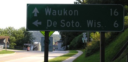
8a) Facing west on 9 (7/14/02)
Photo by Jason Hancock
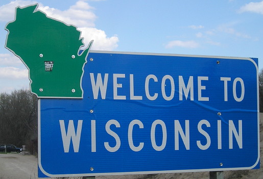
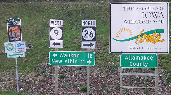
5) Jason says, "This clutter of signs is posted once you get off the bridge." And it holds a lot of what you get entering and in Iowa: the state welcome sign, county sign, city limit sign, scenic byway, Great River Road, and then the LGS and standard shields. The setup has changed quite often:
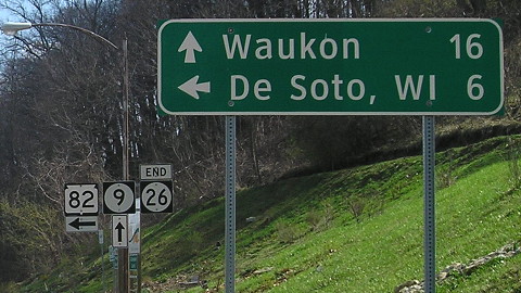
8b) Facing west on 9 (washout at top due to late-afternoon sun) (9/7/06)
8c) Facing west on 9 (4/17/15)
Facing west on 9 (9/7/06)
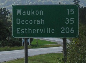
It's a long way across the state to Estherville, the next town above 5,000 after Decorah. (Funny enough, though, I would be in Estherville the next day.) Signs on 9 between Decorah and Estherville use those cities as the third destination. The halfway point between the cities is four miles east of Hanlontown, or three miles east of I-35/IA 27.
Surounding area information: More Lansing views (4/17/15)
Yes, it's really, really a dead end. This is where X52 turns south and Front Street goes north under the very west end of the bridge.
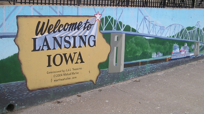
The thoughtful residents of Lansing welcome tourists with not just a mural, but a public restroom.
Facing north
In fall 2015, when I was taking more pictures of the underside of the bridge on a cloudy day, I struck up a conversation with a local resident. He said the bridge used to have wood decking for the roadbed, and then the steel deck placed when the bridge was reopened in 1957 slightly increased the maximum clearance.
Pictures by Jason Hancock: Second, fifth, eighth-tenth, and thirteenth, 7/14/02
Pictures by me: First, third, fourth, sixth, seventh, twelfth, fourteenth, and fifteenth, 9/7/06; 4/17/15
Page created 2/4/03; last updated 4/7/16