


WEST End: I-80 exit 123/I-35 exit 72, West Des Moines, Polk County
Click on each thumbnail to see a larger image.
|
Facing
west on 235
|
|
 |
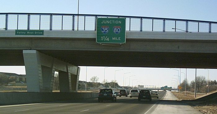
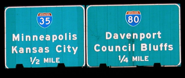
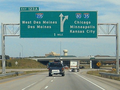
This is the second sign facing west to have I-35/80
listed. Clive is half a mile north of the interstate. Photo by Jason Hancock (January 2006) |
 |
In this picture, you can see the bridge style used
throughout the reconstruction project. Prior to the 2002-07 project,
the asphalt and cement work on I-235 was so piecemeal that official
paving records simply listed the entire road as "Various". Photo by Jason Hancock (January 2006) |
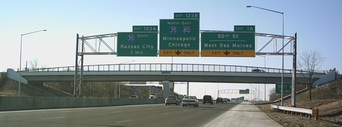 |
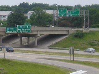
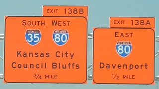
Instead of Exits 0B-A, the new signs at I-235's west
end use I-80's exit numbers. The 50th Street exit is a westbound
exit-eastbound entrance-only partial interchange. Photo by Jason Hancock (January 2006) |
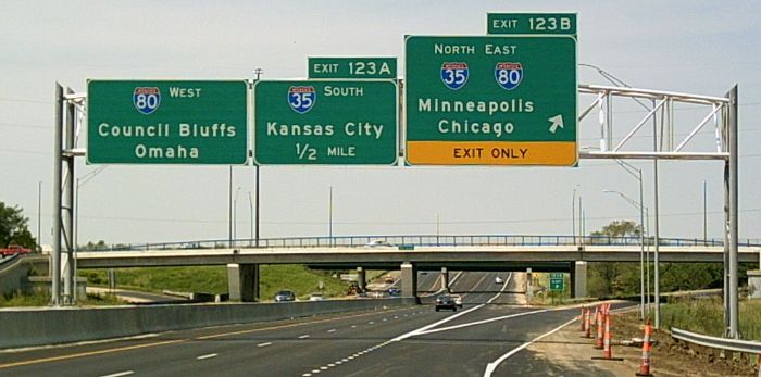 |
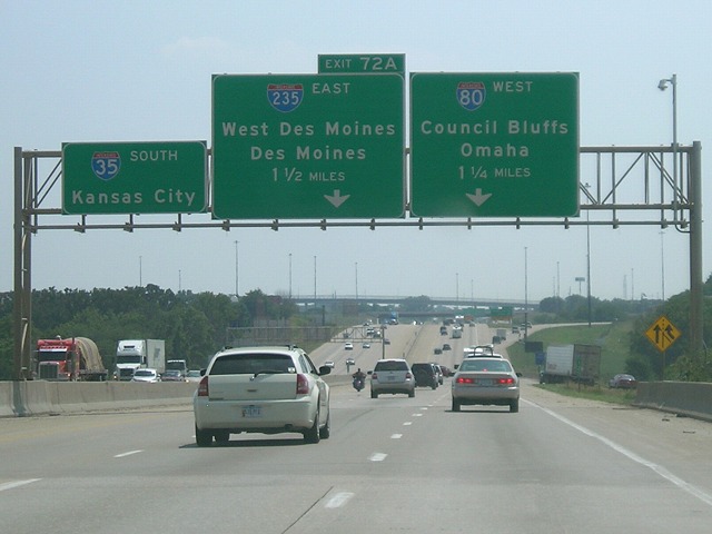
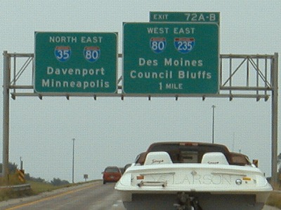
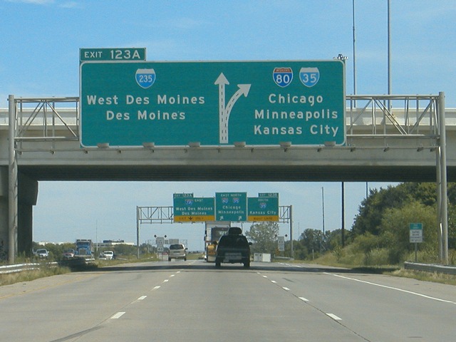
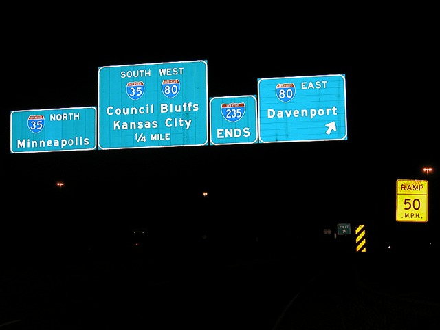
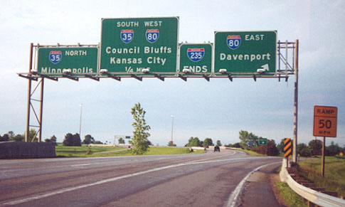
Traffic that does not exit follows a 2-lane road
through the middle of the interchange. It is interesting that these
signs go straight for Chicago instead of Davenport. Eastbound 80 does
the same thing (see that section), but in this case it would seem that
more local travelers would be using 235 and Davenport would be a more
logical choice. Photo by Jason Hancock (May 2005) |
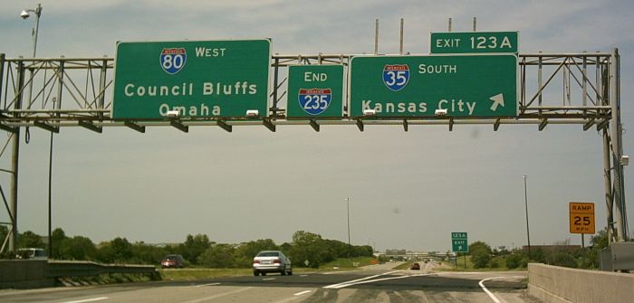 |
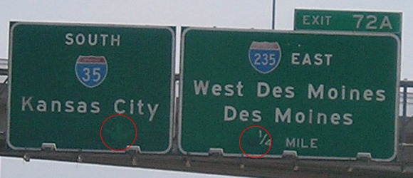
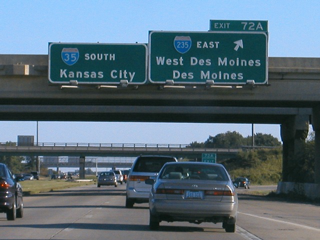
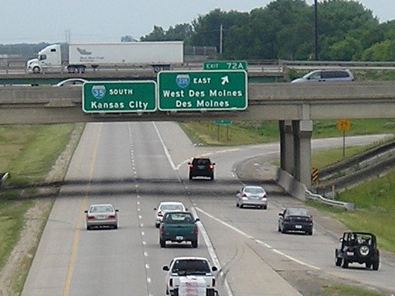
The new sign for southbound I-35 is shorter than the
one it replaced because the arrow is on the side instead of underneath.
Also, the middle used to be "235 Ends" instead of "End 235" - and
notice in this case how the "End" gets the larger initial letter. That
is not always the case. Photo by Jason Hancock (May 2005) |
|
Facing
north on 35
|
|
 |
I-35/80 around Des Moines underwent a lane-expansion project in the 1990s. Despite I-35 being the lower number and thus supposedly the "dominant" route, mile markers and exit numbers follow I-80. (Mainline-wise, it's a wash, since 80 joins 35 here and 35 joins 80 at the other end.) (8/1/07) |
 |
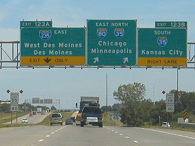
In 2001, a signage replacement project reconfigured how the interstates split. Instead of I-35 getting an exit number based on I-80, as seen in this picture by Jason Hancock, I-235 got an exit number from I-35 and I-80 was left without one. In this split of "equals", I think this is an acceptable way to go. It's better than one of them exiting from itself. (8/1/07) |
 |
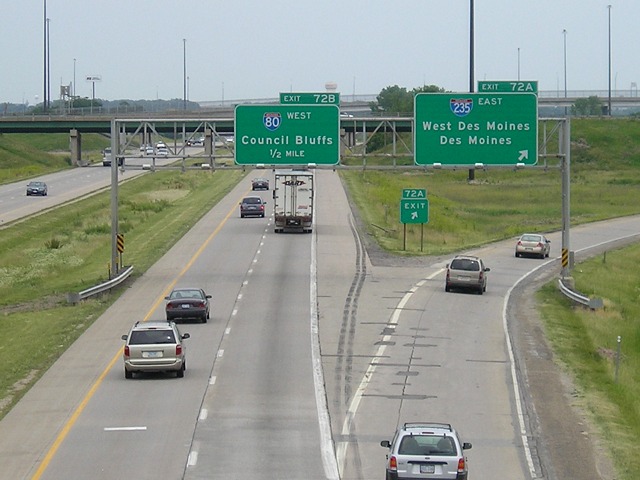
Council Bluffs is always the top "control city" for westbound I-80 due to Iowa's rules. Omaha is added as a second city here and at I-680. In contrast, eastbound 80 in Omaha goes straight for Des Moines. (8/1/07) |
 |
The two button-copy signs on the left were originally put up at the interchange when it opened in the late 1960s. A closeup of the signs on the left is below. (6/24/06) |
 |
Circled in red are scars from where arrows used to be on the signs. Closer examination under different lighting conditions reveals two more interesting things: 1) The I-35 shield used to be a little to the left, and an IA 60 shield was beside it until 1969; and 2) The word "Next" was before the arrow on the 235 sign, so it originally read "Next Right" or "Next Exit" (probably the former) with the arrow between the words. (6/24/06) |
| The last original interstate signs in Des Moines were replaced sometime between June 11 and July 3, 2007, fast-forwarding through 35 years of sign design to include the newest improvements (and I use that word very loosely): Larger initial letters and the Clearview font. (8/1/07) | |
 |
The second pair of original 1960s signs to survive into the 21st century at the 235 exit. There used to be an IA 60 shield on the right side of the I-35 sign; that was removed in the Great Renumbering of 1969, as 60 was broken up into IA 5 south of Des Moines and IA 17 north of Granger, with I-35 and IA 141 in the middle. (8/6/04) |
 |
View of the same sign set from Westown Parkway. Notice the quick merge eastbound 235-to-southbound-35 traffic must make. (6/10/07) |
 |
 Views from Westown Parkway with old
and new
"End 235" sets kind of visible. (8/6/04 and 6/10/07) Views from Westown Parkway with old
and new
"End 235" sets kind of visible. (8/6/04 and 6/10/07) |
|
Facing
north on 35
|
|
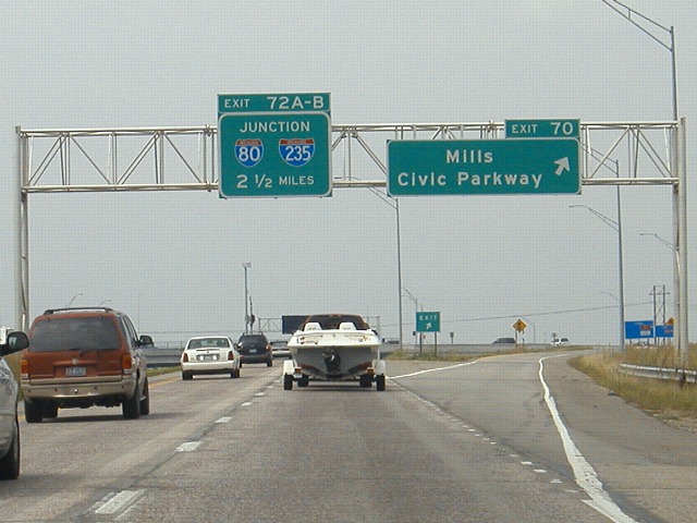 |
The Mills Civic Parkway interchange - Iowa's first SPUI - opened on June 6, 2003. (8/8/04) |
 |
We're still on I-35 at this point, so why doesn't the left sign say something like "Straight Ahead"? One possible explanation is that this stretch of I-35 between Grand Avenue and I-80 was originally intended to be a part of I-80, so it's possible that the original sign in this position was identical and its replacement was not updated. (8/8/04) |
 |
View from Ashworth Road. Topographical maps indicate that the west mixmaster was originally a simple cloverleaf interchange with one exception, a flyover ramp from eastbound 80 to northbound 35/80. Today, the University Avenue interchange to the north has been brought into the mix - sort of. Eastbound 80 now has the University exit before it joins the mainline, and northbound 35 has its own University exit (72C) before that 80 traffic merges. This can make getting from northbound 35 to the Hickman Road (US 6) exit dicey because two lanes of traffic must be crossed. (6/10/07) |
|
Facing
east on 80
|
|
 |
Advance warning of the interchange comes after the Waukee rest area. The sprawl on 80 doesn't begin until you cross under Ashworth Road. (For now.) (8/19/04) |
 |
This graphical BGS is the westernmost one to reference Chicago, probably to stop through travelers from continuing straight ahead on 235. Aside from this interchange, Chicago won't show up on a mainline BGS again until I-280. (8/19/04) |
 |
I-80 crosses under 60th Street in West Des Moines and enters Polk County. As late as 1990, this was the westernmost extent of development. (8/19/04) |
 |
The last BGS on I-80 before the mainline becomes I-235. There's also a set of ground-mounted shields at the split. Traffic going to the right will then have a choice between southbound 35 and eastbound 80. One sign on that ramp, an original that was replaced in 2003, shows that an IA 60 shield and the word "Davenport" instead of Chicago were originally included. (8/19/04) |
EAST End: I-35 exit 87/I-80 exit 137, near Des Moines, Polk County
|
Facing
north, but heading east, on 235
|
|
 |
TOP: Prior to construction of the east mixmaster, these
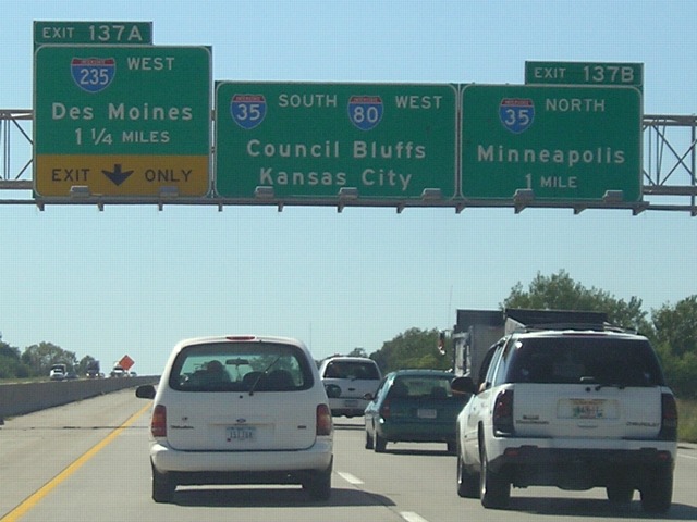
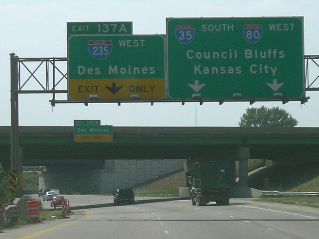
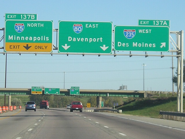
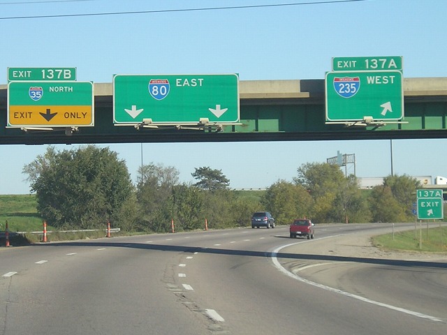
were the signs on 235. (7/17/04) BOTTOM: These temporary signs in 2007 include I-80's exit number instead of I-235's (14) or I-35's (87), meaning that I-80's exit number is used in THREE directions - except that on I-80 it's exit 137! Interestingly enough, state maps have this labeled as Exit 138, even though mile marker 138 is on the east end of the interchange, indicating it is mostly in mile 137. The I-80 numbers also appear on westbound 235 at the west end. I think this is wrong for two reasons: 1) 235's own numbers should be used; or 2) Since here I-35 goes north, I-35's numbers should be used on the north-south exits. (8/1/07) |
 |
This sign gantry has since been taken down for construction and reconfiguration of the interchange. This night view makes a discrepancy move visible: Look at the "O" in "North" and "Minneapolis". They appear to be nearly the same size, and I think that they were switched - that is, the thicker "O" in "North" should have gone with "Minneapolis" and vice versa. (7/17/04) |
 |
Daytime view of the pre-reconstruction "235 Ends"
signage. Photo by Jason Hancock (May 2001) |
|
Facing
west on 80
|
|
 |
The Des Moines beltway was on the planning books for 30 years before it became a reality. The first segment, US 65 from I-80 southward to IA 163, opened in 1994. As noted above, state maps - and newer signs on I-35 and I-235 at the mixmaster - have the mixmaster interchange labeled as Exit 138, rather than the 137 on the signs seen here. (8/1/07) |
 |
The left-aligned exit tab for I-235 gives advance
warning that it will be a left turn. All signage for northbound 35 in
the Des Moines area uses Minneapolis
as the northbound control city. However, four different places are
listed on the bottom of the next four northbound mileage signs: Ames,
Mason City, St. Paul, and Minneapolis. The most prominent use of Mason
City is on US 20 at that interchange. (8/1/07) |
 |
I-80 never technically enters Des Moines. The city never extended much of its northern boundary past Aurora (42nd) Avenue, and the east-west portion of 80 is in the area of 49th-50th Avenue. On the other hand, in the mid-2000s Ankeny annexed a strip a land on the east side of I-35 southeast of the city, and current maps (DOT PDF) show that the northeast quadrant of the interchange - including the westbound lanes of I-80 and the position this photograph was taken - is now within Ankeny's city limits. (8/1/07) |
 |
"False multiplex" signage inside the mixmaster, after the exit for northbound I-35 but before the exit for westbound 235. Technically, we are not on 235, and southbound 35 has not yet merged onto 80. (9/1/07) |
 |
Perspective before any construction began in the area. Notice the gantry for 235 at far left. (12/24/01) |
 |
Six and a half years later, the new bridge for north-south traffic can be seen in the background. Also notice a secondary exit sign that just says "Des Moines" on the foreground bridge. (8/1/07) |
|
Facing
east on 80, but heading north on 35
|
|
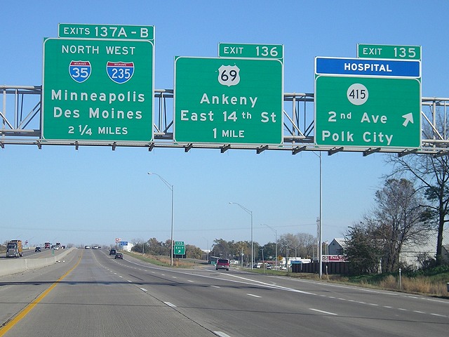 |
First warning of the east mixmaster at the IA 415 exit. Notice the difference in labeling on the two signs on the right: The IA 415 sign gives the street name first, as it should, but the US 69 sign puts the street name under the town (and spells out "East" which is different from the signs on I-235). (10/31/07) |
 |
This is the last time I-35 crosses US 69. Going southward,
the two routes cross and bump in Decatur County; cross three times in
rural Missouri; merge, split and then cross in suburbs and Kansas City
MO; and merge and split twice on the Kansas side of the Kansas City
metro area. This is also the last point US 69 intersects an interstate,
as it does not quite reach all the way to I-90. I have no idea why the "WEST" on the middle sign is so tiny. (10/31/07) |
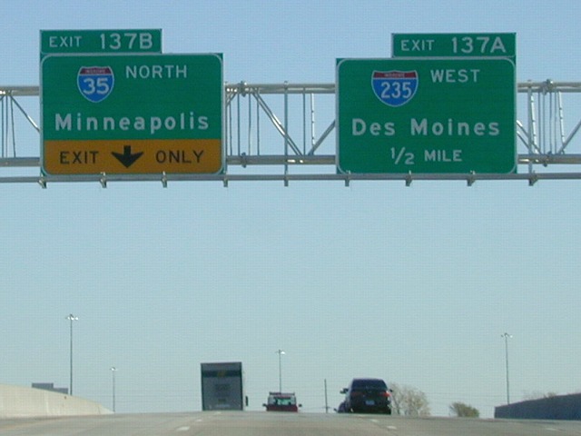 |
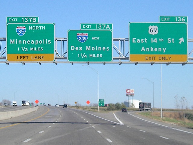
Left/right exits are carefully indicated by the tabs approaching the mixmaster. When the new lanes are open, traffic exiting 80 will still exit left but join the north-south lanes from a collector-distributor lane on the right instead of the left. (11/1/02) |
 |
The exit for 235 comes before crossing what were the mainline southbound lanes for the mixmaster but are now collector-distributor lanes. The I-35 exit comes after the new mainline lanes. (10/31/07) |
 |
The signs of the previous gantry are duplicated on the original southbound-lanes bridge without cities. (10/31/07) |
|
Facing
south on 35
|
|
 |
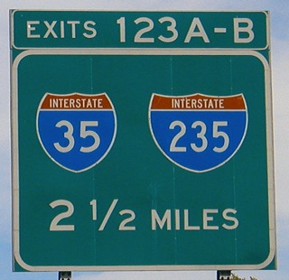
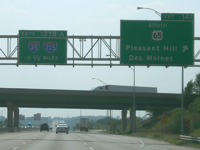
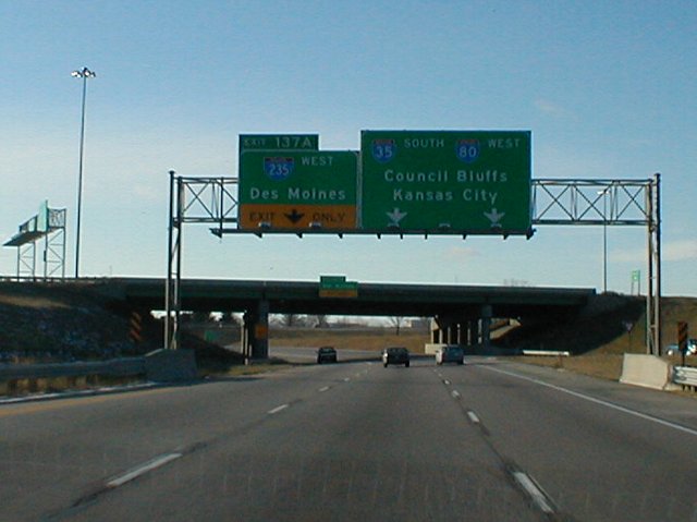
This advance mileage sign south of the IA 160 interchange has been removed. Because the Corporate Woods Drive interchange has been built since this picture was taken, the 80/235 advance sign has been put on a new gantry with a distance of 2½ miles. (10/2/01) |
 |
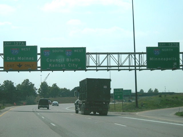
A nighttime view of the graphical BGS that replaced the signs shown below. All of the signs on southbound 35 approaching the mixmaster were replaced in mid-October 2007, all using I-80's exit numbers. And I do mean numbers, plural - THIS sign says Exit 137, which as discussed above is correct mileage-wise, but the next sign said Exit 138 (for about a month). Why these new signs are NOT using I-35's numbers is unknown. (10/31/07) |
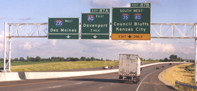 |
This sign set was up from about fall 2003 to fall 2007.
It uses I-35's numbers, which it should, but puts them in the wrong
places - Exit 87A where it is indicates I-35 is exiting from itself.
Instead, the A-B should be on I-235 and I-80 eastbound. Photo by Jason Hancock (2004) |
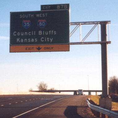 |
This sign was recycled from a ground-mounted position
to an above-lane spot. There had been an arrow on the right side for
the exit. Photo by Jason Hancock (2004) |
 |
Another "false multiplex" sign. This is placed after I-35 traffic exits to join 80, but before the ramp to eastbound 80. Continuing straight ahead will start on westbound 235. (7/19/05) |
Jason Hancock's Des Moines picture page (see "East Mixmaster" and "West Mixmaster" sections)
Page created 10/14/07; last updated 11/4/07