(but mostly about the Lincoln Highway there)
This started with a simple question: Was the Crawford County Courthouse ever on a highway route?
After a once-interrupted 17-hour marathon using every primary source available online in the late 2010s, I had an answer yes. However, the answer came with a pile of revelations, maddening non-answers, dead ends, and false positives regarding the city's most famous route, the Lincoln Highway. That, in turn, led to sporadic shorter marathons over the next week trying to find just the right combination of words in the online archives of the Denison newspapers (the Bulletin and Review, which is where all of these citations come from, under the domain name for the library, Norelius) for clues.
Just because you have an electromagnet for finding needles in haystacks doesn't mean the needles won't be bent.
There were two issues posing a challenge for this series. First, the creation of the primary system did not immediately put roads inside cities under state jursidiction, and Denison is too small for map insets. Alignments remained based on the auto trails, and those routings frequently changed in the 1910s. The earliest Iowa Highway Commission construction documents, either for this reason or an aesthetic one, did not draw highway lines inside city limits. Second, on March 7, 1938, Denison renamed every street in the city except for Main and Broadway. Its grid doesn't line up uniformly, and city leaders were trying to impose some sense on it. This meant that references before then literally could not be found on a map today. It's enough to make a sane person, or at least one not deeply involved with the community, surrender.
But I found a Rosetta Stone maps from the Sanborn company, which produced detailed maps of cities and buildings in the late 19th and early 20th centuries designed to be used for determining fire insurance. The Library of Congress has Denison's Sanborn maps from 1913 right when the Lincoln Highway came through. That provided the key for a significant portion of the city.
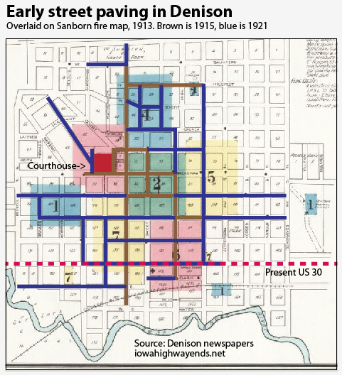
To illustrate, here is an grid of Denison's 1915 and 1921 street paving projects overlaid on a Sanborn map. The courthouse square is in red.
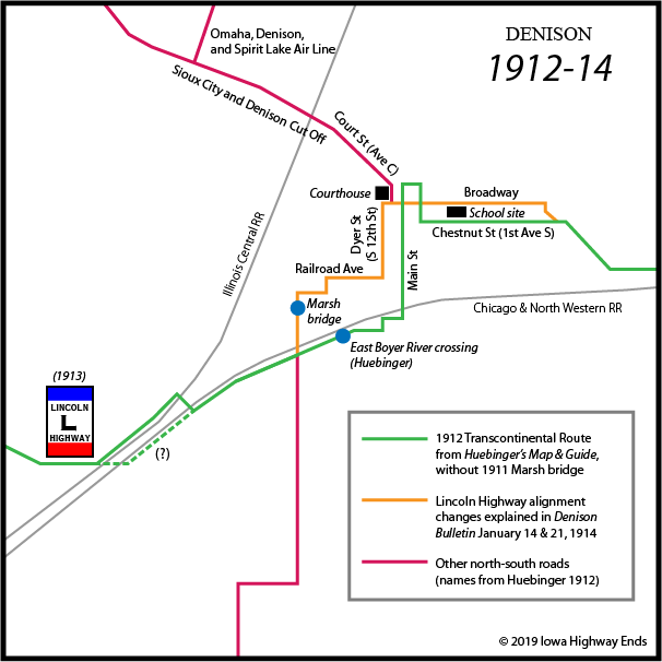
That helped me get a lay of the land. It seemed to jibe with Huebinger's Map and Guide for Iowa Official Transcontinental Route and its very different lines than what today is 4th Avenue South. Research soon made clear that at least part of the Transcontinental map became the basis for the Lincoln Highway at its dedication October 31, 1913 and then changed almost immediately.
| Denison Bulletin,
January 14, 1914 Mark Highway Through City. Marking the Lincoln Highway through the city of Denison was begun last week, and already there is contention over the matter. The officers and directors of the Transcontinental Route changed the original route through Denison to make it more direct by cutting out the turn round the block from Broadway to Tremont street, the line thus running from the Denison Hotel corner to Dyer Street and thence south to Railroad Avenue and thence westward to cross the big cement bridge. ... On recommendation of the officials there will also be a cut-off route marked for the Lincoln Highway that will take tourists through the south part of town and make it unnecessary for them to come through the business district unless they desire to. This should not be done. If there is anything in having the route through the city at all, and if any money is going to be expended for making it a good route, it should be where the best impression of the city will be given to tourists and not where it appears worst. ... People who tour in cars ought not to be in such a terrific hurry that they cannot take time to see the towns they go through. |
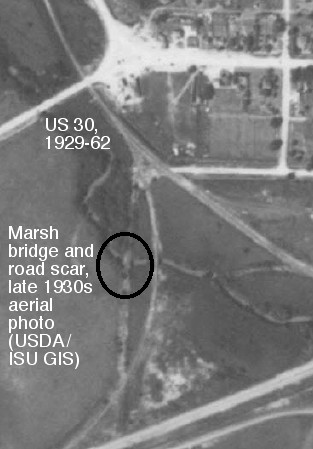
And lo, two problems present themselves at the same time: A signed Lincoln Highway that follows neither the Transcontinental nor 4th, and a "big cement bridge" that didn't exist on any map I had. There is no clear location for a potential bridge marked in the 1912 Huebinger's Automobile and Good Road Atlas of Iowa, the Transcontinental map, or the 1920 Anderson Atlas of Crawford County...
...unless it wasn't showing because it was inside city limits, which could be the case. The 1914 Highway Commission county map of Crawford County might show it. Further wading into the archives yielded a true result three years earlier.
| Denison Bulletin,
June 7, 1911 Finest Bridge in the County to be Erected in Denison The board of supervisors last week let the contract for a new cement arch bridge to cross the East Boyer in the city limits of Denison, on the road running north from the Northwestern tracks and the gravel pit on the southwest of town. The new bridge is to be 100 feet long, with a 60-foot arch underneath to carry the water, and the whole structure will cost $4300. The contract has been let to the Marsh Engineering Co. of Des Moines, the firm which built the great Locust street bridge in Des Moines, and the bridge is to be completed in October. |
Why wasn't this on the Huebinger guide? A promotion inside the guide says all publications would be ready April 1, 1912. If there was a "field check" the summer before, it wouldn't have been able to account for the bridge. (That is, assuming there was a field check; a mislabeling of Tremont Street [1st Avenue North] as Fremont Street makes me wonder.) Regardless, any routing that was in use between 1911 and 1929 from the corner of the city southwest to what today is the Tyson Fresh Meats plant (formerly Iowa Beef Processors) was thoroughly abandoned immediately thereafter. By the late 1930s, aerial photos show that routing reduced to a barely-visible scar and it was so forgotten that neither Lincoln Highway historian Gregory M. Franzwa nor the Lincoln Highway Iowa Map Pack invoked it. I'm not 100% certain of the road's path from the bridge to where the two railroads start paralleling each other (there's a spur line I haven't drawn in, and Huebinger's map doesn't quite line up with modern maps). There is one place that shows the route with the Marsh bridge: A Complete Official Road Guide to the Lincoln Highway, Fifth Edition (1924). That map doesn't go far enough to show the exact rail crossing.
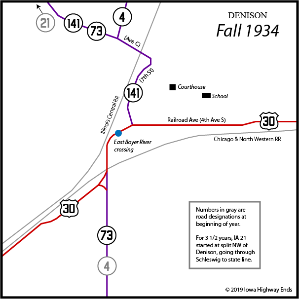
Now, let's look at the other early highways in the area, created in 1920, when the Lincoln Highway was numbered IA 6. IA 4 was a north-south border-to-border route from Spirit Lake to Hamburg, and its stairstepping nature resulted in a slow carve-up into other highways. Notably, from Denison south to Hastings, it was not made from existing auto trails. IA 34 was the "Sioux City and Denison Cut Off" and came into Denison to meet the Lincoln Highway wherever it was.
When did the Lincoln move down to Railroad Avenue, now known as 4th Avenue South? I couldn't find a definitive answer. Results were cluttered with national developments about the Lincoln Highway (as any Good Roads Movement-supporting publications would do). But it does seem that the route in the west part of Denison switched from Dyer (South 12th Street) and Railroad to Main Street and State Street (5th Avenue South) sometime in the decade, perhaps confirmed by the move of the Lincoln Highway Garage to "the brick garage on Main street, at rear of opera house" according to a Review ad February 20, 1918. Even today, the building immediately south of what's now the Donna Reed Performing Arts Center looks like the correct type of structure. Note also, in the paving map back at the top of the page, that part of the street running south from the courthouse was not in the 1921 paving plan, another sign the Lincoln had moved to Main.
| Denison Bulletin
and Herald, June 25, 1919 Don't Believe in Signs? It should be Denison's duty to put up a sign at the Broadway and Main street intersection and the Main and Tremont street intersection, to direct tourists where to turn for the Lincoln highway and the Sioux City cut-off. Every day cars are driven up north Main street only to be lost in the forest (Grace park) and have to turn back. They certainly do not leave Denison with any charitable feeling toward our city, under such circumstances. Why can't Denison do this much? [Grace Park was on the north side of today's 5th Avenue North. Going there meant eastbound Lincoln Highway travelers had missed the turn onto Broadway.] |
At some point the cutoff editorialized against in 1914 became the Lincoln Highway mainline, synchronizing the Railroad/Main/State alignment (4th Ave S/Main/5th Ave S) inside the city with the Map Pack. A tiny item in the April 12, 1922 Review mentioned a new gas station "at the foot of Main street, where the street intersects with Railroad avenue on the Lincoln highway. The location is a very desirable one, for the reason that a large majority of auto tourists pass that particular point." But depending on how it's read, the Lincoln could be Main, Railroad, or both.
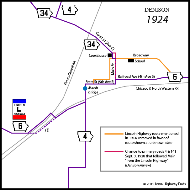
By 1924, the Iowa Highway Commission was looking to straighten the road between Denison and Dow City, and make it run exclusively south of the Chicago and Northwestern tracks there. As reported in the March 11, 1925, Review, "The plans as outlined call for a viaduct over the Northwestern railway, just north of the McHenry residence, west of the city limits, and this would necessitate the road running west on Railroad avenue instead of State street as it does now, in order that a proper angel [sic] be had for an approach to the viaduct."
According to the W.W. Hixson and Co. 1930 Plat Book of Crawford County, Iowa, digitized at the UI library, William McHenry owned the land in the area the Northwestern and Illinois Central railroads diverged. (But on that map, a line that would have connected the gravel to the Marsh bridge isn't shown.)
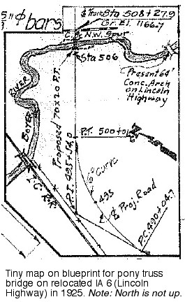
The Highway Commission's file for bridges and culverts along the new route is dated August 1925. It's here that we find a tiny illustration marking "Present 64' Conc. Arch on Lincoln Highway." But then plans were put on hold.
On October 16, 1926, IA 6 became US 30 and IA 34 was renumbered IA 141 so the number could be used for US 34. Ordinarily, this would be one of the more important developments in a highway chronology, but no number-change stories specified streets.
On April 27, 1927, the city of Denison formally renamed Railroad Avenue and Columbia Street (east of present-day South 24th Street) Lincoln Way. But as discussed earlier, the road would carry that street name only for 11 years.
Just over a year later, in the summer of 1928, there was a change right by the Crawford County Courthouse. "Primary roads numbers 4 and 141 through the business section have been changed and the new highway was marked Monday," the Review said September 5. "The new route follows Main street north from the Lincoln highway to Tremont street, and runs one block west to Court street, to where it connects with the old route." At the very least, this change moved the two routes from being right beside the courthouse to half a block east and then glancing the northeast corner of the square.
But in the Depression era there was a much bigger change: Paving US 30 through Crawford County in 1929, which removed it from the Lincoln Highway alignment between Denison and Dow City, and paving IA 141 from Charter Oak to Denison a year later, including a bypass on the west edge of town. The Marsh bridge would be abandoned and gone by the 1950s. The concrete curve from the US 30 paving project, drafted in the bridge diagram above, got 30 years of use with abandoned portions visible for another 30.
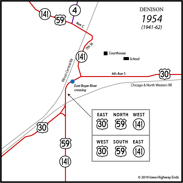
After the federal highway system was created, those who weren't on it were looking for ways to change that. In late 1930, a string of county seat towns running north to south gained an opening through an otherwise inconsequential addition to the state highway system. In the fall of 1930, the Highway Commission agreed to a road running north from 141 to Schleswig, but by the time it would have been signed (as IA 150), the primary road addition went up to Holstein and it became an extension of IA 21. Five months later, an association was formed to promote an extension of US 73, in a lead-up to one of the most eventful years in Iowa highway history, 1934.
US 73 would have fit perfectly between US 71 and 75 into the highway grid in Iowa. The Highway Commission helped this along by, in early 1934, joining together IA 21 north of Denison with IA 4 through and south of Denison and then, a month later, renumbering the entire route as IA 73. Minnesota and Missouri did the same. (It would be signed in June, according to the Cherokee Chief and the Iowa highway map of that month.) But the American Association of State Highway Officials had a different plan, and in December, news came that IA 73 would become US 59. It was signed in mid-February 1935 as part of the last major expansion of US highways in Iowa. US 73 was extended through Nebraska instead. The change in number did little to dampen the spirits of those who wanted the federal route in the first place, though. It's possible, though in my opinion unlikely, that IA 4 remained signed to US 30 for some time.
On April 1, 1941, IA 141 became a highway across half the state. It was extended eastward from Denison to Des Moines following steady additions that had been made to the system with IA 46 connecting little towns along the Chicago, Milwaukee, St. Paul & Pacific Railroad (the "Milwaukee Road"). The two numbers were virtually equal in length, 73 miles vs. 70, but the 141 number stayed, eating up 46 and also IA 89. This created a "wrong-way" multiplex running north and south, with 30 and 141 going opposite directions on US 59.
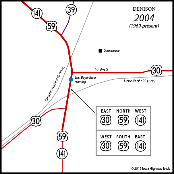
US 30 would be made a four-lane city arterial in 1958. In 1960, two more lanes were built on US 30 from southwest of Denison (southwest of this map) to Dow City, which made it the first rural four-lane segment of US 30 in the entire state. Ironically, some 25 years later (date unknown), the older lanes eastbound, closer to the railroad were removed.
Also in 1958, after a series of fatal accidents, the commission started plans for a four-lane road from the 30/59 junction on the south side of Denison to the 59/141 junction to the northwest. It would not be a true expressway, but rather have some semi-complicated intersections, and relocate the 30/59 intersection to the south. The old roads of both are still used as frontage roads in the southwest corner of the intersection.
The projects were done in two segments, north and south of the north 30/59 intersection. The US 30 portion opened November 24, 1962. The new 59/141 four-lane from US 30 to their split 3 miles northwest of Denison was open to traffic November 15, 1967, taking the highways off the curved street originally built in 1930. This slightly changed the south end of IA 4, which had ended at Avenue C (previous alignment of 59/141).
The last change to highways in the Denison area happened 14 months after that. The last remaining piece of IA 4, from Denison to Odebolt, became IA 39 as part of the Great Renumbering of 1969.
Here are the absolutely-100%-known changes to numbered routes in Denison.
| July
1, 1920: Primary highways numbered in Iowa. Lincoln Highway
becomes IA 6; IA 4 and 34 also in area October 16, 1926: IA 6 becomes US 30, IA 34 becomes IA 141 September 3, 1928: IA 4/141 changed slightly around courthouse 1929-1930: Paving for both US 30 and 141 create new alignments west of city December 1, 1934 (signed February 15, 1935): IA 4 becomes US 59 April 1, 1941: IA 141 extended to Urbandale 1958: US 30 made four lanes (as urban arterial) in city 1960: US 30 four-lane expressway opens southwest of Denison to Dow City (not on map), removed years later November 24, 1962: Relocated US 30 (with part of 59 and 141) opens from South 4th Avenue southwestward November 15, 1967: Relocated, four-lane US 59/IA 141 opens from South 4th Avenue northwestward, including change in location of IA 4's south end January 1, 1969: IA 4 renumbered IA 39 |
Page created 4/25/19; last updated 6/19/22