
(July 1, 1920-October 16, 1926)
- In 1920, they knew it as: The Sioux City-Denison Cutoff (3 counties)
- We know it as: County Road D25 (formerly IA 982) and IA 141
- Let's get granular:
- In Sioux City: Combination Bridge, 3rd Street, Pearl St, 4th Street, Plymouth Street, Westcott Street, 2nd Street/Fairmount Street (EB) and 1st Street (WB), Fairmount Street, Leech Avenue, Rustin Street, Morningside Avenue, Smithland Road
- Sioux City to Smithland: D25 with some small exceptions:
- Vacated road at half-section line, Buchanan Avenue, County Home Road
- A slight realignment at the Bronson corner in 1957 as the C&NW railroad was being abandoned there. Part of the old route remains as a private driveway.
- A harder corner north of D54, and a vacated road on quarter-section line just south of it
- Grundy Avenue and 298th Street, which doesn't exist west of D25 and mostly doesn't exist east of a driveway but still appears on Google Maps just west of Holly Springs
- A vacated road running northeastward across Humbolt Avenue, then east, then hooking around the north side of German City Church, active road Hancock Circle, and vacated south-southeastward diagonal between Hancock Avenue and Lum Hollow Creek
- Not only is German City Church (née St. John's Evangelical, est. 1882, current building 1907) still active, it has a website!
- Smithland: State, Washington, Hickory, and Bridge streets
- Smithland to Mapleton: 330th Street, Lenox Avenue (and vacated segment), Orange Avenue, Pecan Avenue, 120th Street, Pine Avenue, 130th Street, and from the intersection of 130th Street and Plum Avenue, a straight line east to meet up with Sioux Street. (The sliver of concrete just to the north, repurposed for a trail, is part of paving in 1928.)
- Mapleton to Charter Oak: IA 141 with a few more corners: Walnut and Muckey streets in Mapleton, a squared-off corner at 1st and Railway streets in Ute, and a less-straight segment between 110th and 130th streets
- Charter Oak: Railroad Street, as diagrammed in an aerial photo by the Des Moines Register when new pavement opened in 1930
- Charter Oak to Denison: L51, I Avenue, 180th Street, 6 Mile Road, Goodrich Loop, US 59, Avenue C, Broadway, Main Street
- See also: Sioux City Highway Chronology, and this overly detailed history of early highways in Denison that has about as many questions as answers
WEST End: Combination Bridge, Sioux City IA/South Sioux City NE, Woodbury County IA/Dakota NE
Why would a northwest-southeast road, in it last fraction of a mile, turn southward? Excellent question! I have no idea! But insets in the 1925 and 1926 state maps clearly show 34 was chosen to enter Nebraska while IA 23, the east-west road from Fort Dodge that becomes US 20, goes northwest on Military Road to South Dakota.
Along the route
Bridge
crew finishes span over Maple River
The new 160-foot bridge spanning the Maple river, one-fourth mile
northwest of Mapleton, is now finished. It has been under construction
since September, but owing to the high water and quicksand it was not
completed until May 24. The bridge has an 80-foot span across the river
with two 40-foot approaches.
It has a cement floor and will carry any load, says Mr. Frank Vickery,
foreman for the company which built it. ...
The new road which is still under construction will soon be finished.
When this is completed it will cut the distance to Smithland by nine
miles, and to Danbury by seven miles.
— Mapleton Press, June 2, 1927
(This took the route, by then IA 141, off the section line that goes
through the present-day golf course.)
EAST End: IA 6, now
Main St. at US 30/4th Ave. S (probably), Denison, Crawford County
IA 34's east end depends on when the Lincoln Highway was taken out of
downtown Denison. Avenue C at Broadway, the southeast corner of the
courthouse, might have been the first end, but when the Lincoln was
taken off Broadway for a route closer to the railroad, 34 went down
Main. Searching for answers here resulted in a lengthy Denison
Highway Chronology that has rewritten the Lincoln Highway
Association's official map in this city.
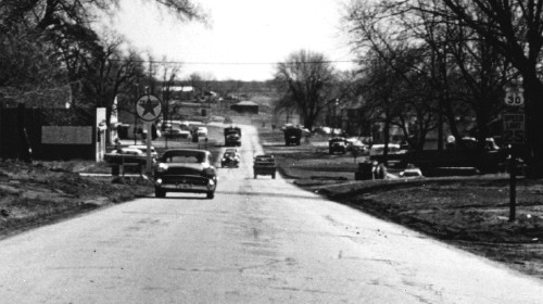
Facing east on 30 (1958)
© Iowa Department of Transportation. All rights reserved.
This photo is after IA 35's time, but it's near its end in Denison. It's about two blocks east of the intersection of US 30 and Main Street. At left is Robbie's Texaco, now the site of a Casey's. The concrete here is likely from the 1929 paving, replaced with a four-lane urban arterial in 1958.
Page created 4/15/20