
(July 1, 1920-October 17, 1983)
- In 1920, they knew it as: Elkhart's connection to the Jefferson Highway
- We know it as: F22, or Northeast 126th Avenue (Polk County does not sign county roads)
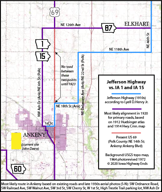
- Let's get granular: Elkhart, the smallest town to get its own highway (1920 pop. 196, 2010 pop. 683), may have been included because it was on the version of the Jefferson Highway that went from Nevada to Ankeny via Shipley and Cambridge. In the 1910s, that route lost ground in favor of one that overlapped the Lincoln Highway to Ames and then made a straight shot south to Des Moines. The road east of Shipley didn't even get included in the county system until 1922.

WEST End: Stop sign, IA 1/IA 15, now US 69, Polk County

Facing west on 87 (1/19/03)
Photo by Jason Hancock
In the last portion of its life 87 was split by I-35. The brown sign is for Big Creek State Park.

Facing west on 87 (1/19/03)
Photo by Jason Hancock
From 1920-23, IA 1/15 (and thus the Jefferson Highway, though the Scenic Byway signs do not follow this) went west/ahead 1/2 mile, then went south on NE 6th Street, which becomes NW Ash Avenue in Ankeny. (Note: This does not align with Lyell D. Henry's book about the Jefferson Highway, which favors NE 22nd Street and then Delaware Avenue/NE 18th St/1st Street in Ankeny. However, it's what the 1912 and 1914 county maps show as the main road, and the 1923 construction plans for the road north of Ankeny indicate there was no road on the section line for 2 miles between Ankeny's NE 18th Street and NE 118th Avenue.)

Facing north on 69 (1/19/03)
Photo by Jason Hancock
*Original Number, Original End*
EAST End: Grant Ave./NE 46th St./R70, Elkhart, Polk County

Facing east on 87 (1/19/03)
Photo by Jason Hancock
According to county maps, this is smack in the middle of Elkhart, pop. 362 in 2000 but nearly doubled in 2010. In reality, this intersection defines defined the southeast corner of the developed area until a subdivision sprung up to the left months after this picture was taken. This is exactly four miles east of US 69.

Photo by Jason Hancock (1/19/03)
This sign set, on the pole in the above photo, marks both the Elkhart (bottom) and Polk County (top) names for the streets; the latter is simply a countywide extension of Des Moines' street system. While this is supposed to be R70, Polk County does NOT sign its county roads.

Facing east on 87 (7/27/11)
The Polk signs have been taken off the pole. The route description in 1936 shows that 87 did not use Main Street.

*Original Number, Original End*
Last seen: 1984 (1983 map)

(courtesy Jason Hancock)
Since 1984, old 87 (now F22) has been paved and so has R70 from Elkhart to IA 931 (the black line at the bottom).
Page created 2/22/03; last updated 1/10/04 3/15/20