
(July 1, 1920-December 31, 1968)
- In 1920, they knew it as: From Albia to Des Moines, it did not follow any major auto trails, but did follow much of the CB&Q (except for between Knoxville and Hamilton, where the railroad went over to Harvey first). From Des Moines northward, a portion of the Des Moines, Fort Dodge, Spirit Lake, and Sioux Falls Highway; a few miles of the Lincoln Highway; from Jefferson to Havelock, the Des Moines, Panora, and Spirit Lake Highway; and from Mallard to Spirit Lake, another part of the DM-FD-SL-SF. (13 counties)
- There was a short portion with an honorary name, registered July 20, 1918. "This route from Knoxville to Des Moines was named in honor of Everett Powers who was the first enlisted man from Richland Township, Warren County[,] and the first to lose his life in action in France on May 27, 1917."
- We know it as: IA 5, old IA 46, Grand Avenue, Ashworth Road, US 6, US 169, IA 141, IA 144 corridor (P54, E57, P46), E53, IA 4 (more or less), IA 9
- Let's get granular: Huebinger's Map and Guide archives helped on parts that overlapped auto trails.
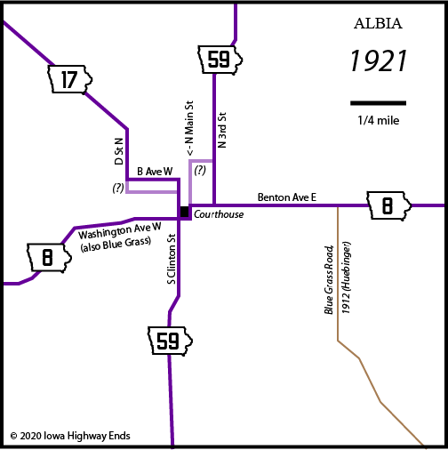
- Albia: Clinton Street, B Avenue W, D Street N
- The intersection that's now IA 137's south end was built in 1939.
- Albia to Marysville: IA 5; 640th Avenue; H33; a series of stairsteps including 624th Place, 625th Lane, 618th Place, and 135th Lane; E Avenue in Lovilia; IA 5; vacated road running into Parker Street in Hamilton; T23 (1 block); vacated road running west-northwest; IA 5; vacated road running northwest and north from driveway; Vermont Drive with vacated bridge over Cedar Creek
- The 1919-22 maps might be interpreted to show the road left Albia via IA 137 and H33 instead. I don't think it can be figured for sure.
- Marysville to Knoxville (1): Cedar Street, Van Buren Drive with vacated road across North Cedar Creek, G76, 150th Place, Story Drive, Shaw Drive, 130th Place, IA 14, 130th Place (broken at IA 92)
- Marysville to Knoxville (2): Cedar Street, Van Buren Drive, G76, High and Poplar streets in Attica, IA 5, vacated road running north from Poplar/5 intersection along section line, Quebec Street, 165th Avenue, G62, IA 5, vacated road north of Pratt Drive on the west side of the houses, IA 5, vacated road from the intersection of IA 5 and Oregon Drive arcing northwest and west, Nixon Street, 150th Place, Business IA 92
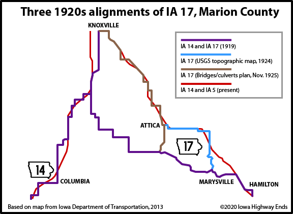
- A 1924 USGS topo map vs. a 1925 culvert construction document, and then the 1925 vs. 1927 state maps, provide differing routes in southern Marion County. (See also map below.) The very first route joined IA 14, but at the same time, the 1914 county map flips the addition/elimination marks on those segments.
- Marysville to Knoxville (3): Cedar Street, Van Buren Drive, vacated road across North Cedar Creek, 202nd Place and vacated extension north, vacated stairsteps north of G71, IA 5, then the above north of Attica
- In late 1925 (though not visible on the state map until later), a new route was approved going east and southeast of Attica bypassing Marysville altogether. The version described here is the one on the USGS map.
- Knoxville to IA 5/92 split: Main Street, Roche Street, Pleasant Street, 118th Place, McGregor Drive west to about 92nd Avenue (abandoned for a length), vacated extension of Lucas Street, Lucas Street, 70th Avenue (not curving to meet the four-lane), IA 5/92 on and just south of the southbound lanes
- IA 5/92 split to Marion/Warren county line: IA 5 (northbound lanes), vacated right-of-way, old IA 5, Inwood Street, 43rd Street, Columbus Street, Monroe Street, State Street, Harding Drive, Old Highway 5 Lane, IA 5 (northbound lanes), 25th Place, Coolidge Street in Swan
- Near the intersection of IA 5 and Geneva Drive (which is where 25th Place used to intersect) is Wheeling Cemetery, the only trace left of that extinct map dot.
- Swan (1920 pop. 238, 2010 pop. 72) was one of the earliest towns to permanently lose its highway connection when the route was straightened in 1928. That straightening moved the highway to parallel the CB&Q (now UP) between Carlisle and Hartford and then angle southeast to run a few miles away from a different line of the CB&Q (later Wabash, now BNSF).
- Warren County (probably): Short segment of vacated road, Cleveland Street, vacated road, Dakota Street, 228th Avenue, Delaware Street, 220th Avenue, Drake Street, Fremont/Vine/Walnut streets in Hartford, IA 5 (southbound lanes), 203rd Avenue (now a driveway), Cleveland Place, S23, 190th Avenue, Blue Place, 183rd Avenue, Arthur Street, School Street in Carlisle, frontage road, IA 5 (northbound lanes)
- All the state maps show IA 17 absolutely going to Swan but missing Hartford by varying distances, whether or not the route actually changed. However, the 1912/1914 county maps and topography of the area make it hard to figure a route that does not wobble its way through Hartford. The route listed here is the red line on the 1914 map.
- The "wobbling" Hartford-Swan route seems to be confirmed via the 1928 graveling blueprint that set the route on its more-or-less pre-four-lane alignment. The connection that no longer exists between Cleveland and Dakota streets was the subject of a 1965 Des Moines Tribune article about the rickety bridge being the only way to get from Hartford to Pleasantville because IA 60 was under construction. The construction project in part was for new bridges along the segment for Red Rock reservoir-related reasons. The old bridge over the South River remained until being washed out in 2008 flooding.
- Warren/Polk county line to Adel: SE 52nd Street, SE 72nd Avenue, SE 45th Street (broken at Des Moines River), Carlisle Road, SE 43rd Street, Vandalia Road, E 30th Street, Grand Avenue, Ashworth Road, roads approximately corresponding to Bluestem Drive and Tallgrass Lane, L.A. Grant Parkway, road behind the houses on Northview Drive, 2nd Street, Ashworth Drive, US 6 (westbound lanes), 288th Trail
- Only the bridge over the Des Moines River was removed but the pavement leading up to it is not accessible — even with a Pleasant Hill city limits sign remaining on a now-dead-ending Carlisle Road (per 2011 Google Street View).
- IA 17 overlapped with IA 2 from the Iowa State Fairgrounds to Adel.
- The connection between Grand and Ashworth remained until 2021, as a scrap of abandoned pavement used as the edge of the parking lot for Val Lanes Recreation Center.
- The River to River Road used Warrior Lane, University Avenue, and 88th Street, but this had changed by 1922, according to construction documents that ironed out the segments on Ashworth and Grant to use the roads that are there today. The old parts weren't deleted from the county system until 1926. Growth of Waukee in the 21st century has resulted in the paving of Grant (formerly V Avenue).
- Rerouting away from University and 88th avoided two RRX's. Part of 88th Street was vacated ca. 2004. The section-line intersection of 88th and Ashworth is marked today by the northwest corner of a fill pond south of I-80.
- Adel: River, 5th, Prairie, 6th, and Main streets; US 169
- That's the route in Huebinger's Map and Guide for River-to-River Road (1910). Adel renamed its north-south streets sometime in the early 20th century; 5th is labeled as Benton and 6th as Elm.
- Adel to Minburn: US 169, Fairground Road (and vacated bridge over Raccoon River), US 169, abandoned road running into a driveway, 215th Street, US 169, 205th Street, Midland Trail
- From just north of 250th Street to just north of IA 44, the original road was a few hundred feet west. In 1932 an elaborate four-curve intersection was built at the present 169/44 intersection; if a grade separation had existed it could have become Iowa's first interchange.
- Minburn: 8th Street on the south side, 5th Street on the north, unknown in between
- A 1919 IHC document is sparse on in-city detail, but it most likely shows Chestnut, 4th, North, and 5th streets, because the road runs east from the school. However, the 1930 paving document marks "Pres. Road" running south of the school on 5th. It makes sense for that version of the route to hit the corner of 6th and Chestnut (the west end of the business block), but I can't know for sure.
- The present 169 crossing at the old Minneapolis & St. Louis Railroad (later CNW) tracks/Raccoon River Valley Trail was not built until 1930.
- Minburn to Grand Junction: US 169, 141st Drive, IA 141 (eastbound lanes), Iowa Street (Perry), 12th Street (Perry), Willis Avenue (Perry), IA 144, 330th Street, Clover Avenue, P54, E57, P46
- A sweeping curve in the southwest corner of the US 169/IA 141 intersection paved in 1930 was abandoned by 1960. This Perry-to-Adel curve would have been following the route of IA 17.
- An original corner in Perry was at the high school (later middle school, demolished 2009). Willis Avenue was made the route on the east side with paving in 1930.
- Grand Junction: Vacated road on north side of railroad; Sandoe, 16th, and Main streets
- This segment, past the Three Bridges area and including two historic bridges, was bypassed in 1921 for "old 30" on Main and 222nd streets in Grand Junction, and then present US 30 on the south side of the railroad.
- Grand Junction to Rockwell City: E53, IA 4, E33, P14, IA 4, E13, G Avenue/Upland Avenue, 390th Street, Traer Avenue, IA 4, Dakota Avenue, Oakhurst Avenue
- The Jefferson-Churdan segment was moved to present IA 4 in 1921.
- Rockwell City to Pomeroy: 8th Street, ???, N57, D26, Newhall Avenue, 170th Street
- It's clear that IA 35/17 came into Rockwell City on 8th Street and then IA 17 continued north on N57/Ogden Avenue, and the road on the west side of town opened in 1938. Everything in between is up for grabs, because there are no city maps. It seems possible that the Hawkeye Cutoff and original IA 23 (with 17 tagging along) used 8th, Main, and 1st streets through downtown Rockwell City, going past the courthouse and the business district, but I have not found any proof.
- Or maybe 17 used Main Street but 23 (future US 20) didn't.
- Pomeroy to Emmetsburg: IA 4
- Emmetsburg to Estherville: Either Lawler Street or Palmer and 3rd streets, N40, B14, Oleson and Thu Street in Graettinger, 425th Avenue, 270th Street, road paralleling CRI&P Railroad on east side, 260th Street (just enough to jump the tracks), IA 4, A48 (short diagonal), vacated road north to 240th Street west of IA 4, IA 4, 230th Street (unpaved connection), A34, IA 4, vacated road between 220th and 210th streets west of IA 4, 395th Avenue, vacated road along the tree line north of where 395th abruptly turns east, IA 4 (but slightly closer to the tracks) to just south of the cemetery, vacated road east of cemetery across Des Moines River
- All the early 20th century maps call the lake on the north side of Emmetsburg Medium Lake, but today it's Five Island Lake.
- Estherville: 12th Street, 8th Avenue, 10th Street, 6th Avenue, IA 4
- The 1st Street cutoff, which enables Spirit Lake-Wallingford traffic to avoid downtown Estherville and two RRX's, is not original; it dates only to 1929 (see "Along the route" below). It remained part of the system for decades, but appears to have been eliminated by 1968, since it's not mentioned in the IA 4 route description.
- Estherville renamed its east-west streets to numbers June 10, 1938 (Estherville Vindicator and Republican, June 14).
- The "New Hotel" and "Rhodes Garage" in the Huebinger Guide remain buildings near the corner of Central and 7th today. This helped in interpreting the 1912 alignment of the auto trail since some names changed.
- Estherville to Spirit Lake: IA 9, A22, N25, 360th Avenue, 155th Street, 355th Avenue, A20, IA 9, 252nd Street, 250th Street, IA 9, Lake Street
- In 1922, the Dickinson and Emmet county boards of supervisors proposed changing the route east of Superior to use 330th Avenue and A22. The IHC rejected this (Estherville Vindicator and Republican, January 25 and June 7).
- Related routes:
- IA 6 (II), which became an extension of IA 60, which became IA 5 (II) in the Great Renumbering — four total numbers for the road between Des Moines and Albia.
- IA 158, a spur to Carlisle probably created when the highway was realigned in the area in 1928
- IA 46 (III), the now-broken segment between University Avenue and Army Post Road in Des Moines
- IA 152 (0): "Assigned to that portion of former Primary Road No. 17 from U.S. 30 east of Grand Junction southeast thru Rippey and Perry to Primary Road No. 16." — Iowa Highway Commission Service Bulletin, October-November-December 1925
- But it didn't happen, hence the "(0)" designation. In fact, IA 17 remained on this segment and redundantly multiplexed to Adel until 1941! This is odd because the 1926 system was intended to eliminate as many overlaps as possible.
- IA 144, extended south from Grand Junction in 1941, although it would have made more sense to do in 1926.
- IA 150 (III), Jefferson to Herndon and later Panora, which 17 superseded in 1941
- This 150 at the time 17 absorbed it included almost all of IA 271 (II), the remainder of which became a short spur to Yale.
- IA 345, spur to Graettinger when 17 was paved in the area
- IA 368 (II), Walnut Street in Hartford after IA 5 was four-laned. A driveway-sized piece remains officially in the state system at the intersection of 200th Avenue and Cleveland Place.
- IA 933 (I), Willis Avenue in Perry post-bypass
- IA 937 (II), 141st Street in the southwest corner of the 141/169 interchange
- IA 975, old IA 5 through Knoxville (now Business IA 92)
- Point of interest: In 1939, the route of IA 17 between Adel and Estherville repeatedly bounced back and forth between paved and gravel. Here's how you would have encountered things: Paved from Adel to Perry, gravel from Perry to Grand Junction, paved from Grand Junction to about E33, gravel from there to Lohrville, paved from Lohrville to Rockwell City, gravel from Rockwell City to IA 5 (now 7), paved with the IA 5 overlap, gravel from IA 5 to Pocahontas, paved from Pocahontas to Estherville, and bituminous from Estherville into Minnesota.
- This included two segments outside of Polk County that used concrete from 1921: About eight miles from Buttrick Creek east of Jefferson to north of Jefferson, and 12 miles from Mallard to Emmetsburg. Plans for the latter were approved in January 1920 (Spencer Reporter).
- See also: Jason Hancock's Highways of Des Moines
NORTH End: IA 4, now Lake St. at Hill Ave., Spirit Lake, Dickinson County
The only reason I can think of for the route not ending in Estherville was because IA 17 was using the Des Moines, Fort Dodge, Spirit Lake, and Sioux Falls Highway north of Mallard. This is weak because there's a lot of the auto trail that 17 did NOT follow, and as mentioned above, the connector road on the west side of Estherville wasn't around. Minnesota did not have a route extending south at the time; original MN 4 south of Paynesville followed US 71 instead.
Along the route
Construction of
bridge on No. 17 to go forward; viaduct planned over M & St. L. R.
R.
A new steel and concrete bridge south of Estherville on Primary road No.
17 will be completed by May 1, 1929, according to the information of
County Engineer F.A. Macdonald. ...
The new bridge is located 500 feet west of the Rock Island bridge, which
will call for a new highway right-of-way approaching the bridge from
both the north and the south. ...
The road will go north from the bridge along the west side of the Rock
Island right of way and cross the land now used for ball park. Here the
road will branch, one route going into the city, connecting with south
9th street, and the other connecting with south 1st street, coming out
at Lincoln street just east of the Lincoln street bridge.
— Estherville News, December 6, 1928
The motorists who travel
through Estherville may be assured of any necessary accommodations. The
business men are congenial and wide-awake. Garages, hotels, splendid
banks and mercantile establishments are always ready to serve the
traveler. The city abounds with good roads enthusiasts and has
accomplished much in the improvement of surrounding highways.
— Huebinger's Map and Guide for Des Moines, Fort Dodge, Spirit
Lake, and Sioux Falls Highway (1912)
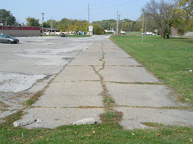
Abandoned concrete between Grand Avenue and Ashworth Road; IA 28 is just to the right; removed 2021 (10/9/20)
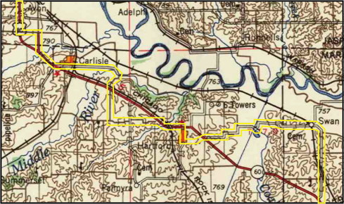
Most likely 1920 route of IA 17 in Warren County, bordered in yellow, on 1957 USGS topo map
SOUTH End: IA 8, now Clinton St. at Washington Ave., Albia, Monroe County
The most likely endpoint was Clinton Street at Washington Avenue, the southwest corner of the Monroe County Courthouse.
Page created 6/21/20; last updated 8/4/22