
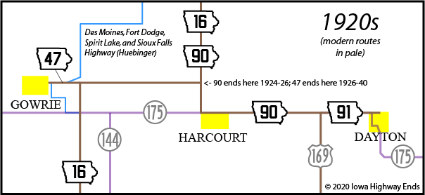
(July 1, 1920-October 1940)
- In 1920, they knew it as: Gowrie's connection to the north-south highway through Webster County
- We know it as: The ancestor of half a mile of IA 175, and the shortest route of the 1920 system
- Let's get granular: 350th Street between Gowrie and Hayes Avenue
- Although Market Street is Gowrie's business district, Main Street is a block north
- Related-ish route: IA 53 (II), a new spur to Gowrie created when IA 175 was straightened in 1953. The through-Gowrie route was 4th Street, Main Street, P33/County Road, 355th Street, and Easter Avenue. The spur used 4th but then turned onto Market.
WEST End: Gowrie, Webster County
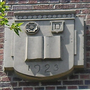
Detail at top of Gowrie school (currently Southwest Valley High School), west side of town (7/25/12)
Gowrie (1920 pop. 895, 2010 pop. 1037) was just off the path of the Des Moines, Fort Dodge, Spirit Lake, and Sioux Falls Highway. A detail map in Huebinger's Guide to that route showed a spur down Market Street ending at Babcock Garage just west of Pleasant Street.
Gowrie is rapidly
becoming a favorite stopping point for tourists. The roads in and out
of the city in all directions are among the best in the state and the
farmers and autoists if the community co-operate to an unusual extent
in the maintenance of the highways. Gowrie boasts of the best equipped
garage and machine shop between Des Moines and Fort Dodge. Two splendid
hotels, the Kennedy and the American House, and three restaurants are
always ready to serve guests in the city. Practically every line of
mercantile business is well represented in the city and the business
men are of the class that always is wide-awake to the opportunities and
the best interests of the city. ... A spirit of prosperity surrounds
the little city of Gowrie and always appeals to the visitor.
— Huebinger's Map and Guide for Des
Moines, Fort Dodge, Spirit Lake, & Sioux Falls Highway
(1912)
EAST End: IA 16, now 350th Street at Hayes Avenue, Webster County
NOT facing east on 47, but close; see map (12/12/05)
The functional equivalent of 47's east end today is the intersection of IA 175 and IA 144, a mile east and a mile south. See more at my IA 144 page.
Points of interest
Supervisors
favor primary road
change
The board of supervisors Tuesday approved the change in the primary
system as petitioned for in the southwest and southeast parts of the
county. The new changes proposes two primary roads instead of the
Harcourt road, one running southeast by way of Lehigh, Otho and Dayton;
the other road through Moorland, Callender and Gowrie.
— Fort Dodge
Messenger and Chronicle, November 12, 1919
Webster County's last-minute attempt to get two primary routes for the price of one failed. However, it did get IA 47 to Gowrie, IA 50 to Lehigh, and IA 91 to Dayton.
IA 47 is one of many routes entirely or partially consumed by IA 175. Despite the road between Gowrie and Harcourt being relocated a mile south in 1941, it would be more than a decade until 175 was put on a straight line skirting the south edge of Gowrie. It's hard to see this on some maps, but instead of following the section line, 175 used Gowrie Avenue, Walnut Street, 4th Street, Market (or possibly Main) Street, a street that was named County Road long before P33 came along, 355th Street, and Easter Avenue to turn 2 miles into 4½. And you couldn't skip it, because there wasn't a road on the section line until 1953.
Then, when Gowrie was bypassed, the town had one more trick up its sleeve. It gamed the system by withdrawing its city limits just enough from new 175 that it was officially "not" on the system but of sufficient population to merit a spur route. That road, IA 53, followed 4th and Market streets to end at Lynd Street, going through the business district. Neighboring Farnhamville saw this and pulled the exact same stunt to get its own. Both towns got to keep their spurs until 1980.
Page created 3/18/20