
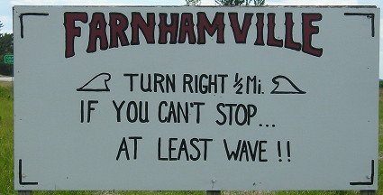
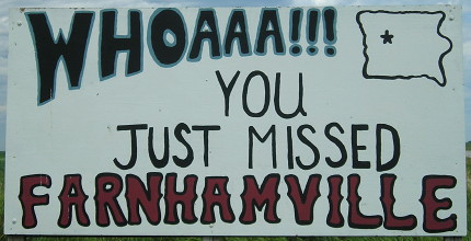
June 24, 2017: Is this an excuse to post one of the best “welcome to” sign pairs in Iowa? Possibly.
At the end of 1939, the expansion of Iowa’s highway system abruptly slowed down at number 372, a spur to Preparation Canyon State Park. During World War II, only 13 numbers were added. Then, in 1946-48, a mini-boom brought 12 more numbers, and that’s where things stayed for a decade.
The Great Commissionings of the 1930s ensured that any town with a population of 250 that was not near the primary road system had a state-maintained connection to that system. Those spur routes often went straight into the business district. But, if a town’s city limits touched an existing route, that town was considered to be in the system. New Providence, 6 miles away from IA 175, got a state highway than ran right to the intersection of Main and Main — but Radcliffe was stuck with 175 running along the south side of town and not into the business district.
Obviously, this would not do. So some towns in that situation pulled their city limits away from the highway by a matter of a few hundred to a few dozen feet, and then told the Highway Commission, Hey, we’re not on the system anymore, we need a highway into downtown. It worked. Mallard got IA 354; Radcliffe got IA 355. Calumet did it in 1946, right as US 59 was being paved on the edge of town; IA 388 was the result.
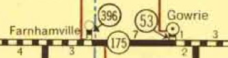
In the early 1950s, a significant percentage of Iowa’s highway system was still gravel. The Highway Commission started to tackle this right before, and while, construction of the interstate system was getting underway. For the most part, alignments of highways didn’t need to be changed as they were blacktopped or paved. An exception was IA 175 through Gowrie. Although it looks obvious now — a straight line from Lake City to Dayton — 175 moved north a mile, went through Gowrie’s business district, and stairstepped out.
 1953 state map
The state ironed that out in 1953 with the intention to pave the road between Gowrie and Farnhamville a year later. Although it is not shown on the 1954 map, the eastern part of the jog remained under state control, christened IA 53 because the number was free.
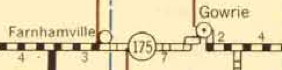
Now, consider this educated speculation. You’re in Farnhamville, and you just saw the Gowrie bypass open, but it keeps a state highway into downtown. How did that happen? Because the new IA 175 missed Gowrie by precisely 165 feet.
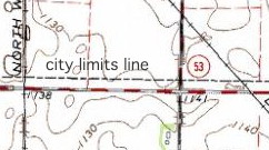 USGS, ca. 1964 (south of Gowrie). The city limits have been pulled closer to Gowrie since that time.
So what happens in Farnhamville? The southern border is pulled northward — by precisely 165 feet. Farnhamville got its spur about 16 months after Gowrie did. The identical distance, to me, indicates either coordination or a copycat move.
 1956 state map; notice how Farnhamville magically moved away from IA 175.
New numbers that followed were realignment-related. Farnhamville, with IA 396, is the last time a town got its own spur highway purely by gaming the system.