
(July 1, 1920-October 16, 1926)
- In 1920, they knew it as: A fragment of Pershing Way (registered August 14, 1919). "This route started in Winnipeg, Canada and over a distance of 1,800 miles ended in New Orleans, Louisiana." However, the Pershing grabbed bits and pieces of other routes along its length.
- The Pershing was predominantly north-south, coming in at Scarville. After going east-west through Cerro Gordo County, it stairstepped down from Nora Springs to Clarksville, joined the Red Ball Route through Black Hawk County, departed that route to head south while hitting Mount Auburn and Van Horne, picked up the Fairfield, Keota, and Cedar Rapids Road from Conroy to Fairfield, and dangled southwest to leave via Milton.
- We know it as: Gravel roads between Nora Springs and Rockford (1920-21)/County Roads B30, T24, and B47, and IA 14
- Let's get granular:
- 1920-21 only: Hawkeye Avenue in Nora Springs including a still-existing but closed 1903 bridge over the Shell Rock River and a railroad underpass built in 1889; Avon Avenue (now broken by US 18), 180th Street, Red Ball Road, Bourn Avenue, 200th Street, and Red Ball Road again (a new road avoiding two RRX's came in 1929); 3rd Avenue NW, 7th Street NW, Nora Springs Road (now you know why), and Main Avenue in Rockford; then east.
- This
is NOT the Red Ball Route (IA 40/US
218). I don't know how they got away with calling an unrelated
but somewhat close route nearly the same name.
- After 1921: B30, T24, B47, 210th Street, March Avenue, and IA 14 to Charles City
- Related routes/Point of interest: The un-duplexed part of IA 53 remained in the state system until 1966 (north of Rockford) and 2003 (east of Rockford) as IA 147. It was renumbered because in 1925, the IHC expected a new federal route, US 53, in northeast Iowa.
- Except
that US 53 didn't happen. Or it might
have happened, only to be immediately replaced by US 55. This is
one of the enduring mysteries of Iowa highways: Was present-day US
52 actually signed as US 53 for a few months? By the time of the
issuance of the final renumbering chart in fall 1926, #53 had been
reassigned to the former IA 55 to Clarksville, to make way for US
55. Multiple newspapers in late 1926/early 1927 reference US 53 —
until, around the end of April, all of them suddenly don't. Either
way, the 147 designation was a 21st-century reminder of the
fluctuations of the early US system.
WEST End (1): IA 19, now Hawkeye Ave. at 1st St., Nora Springs, Floyd County
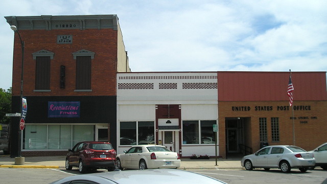
Nora Springs "has a variety of business much more than one would expect to find in a city of its size and the stability of its business houses is one of the features of which Nora Springs is justly proud. ... There is only one newspaper, ably conducted [Only one! -Ed.], two lumber yards, one flour mill, livery stable, dray line, restaurant, and in fact, everything required to make a first-class business town." — Huebinger's Map and Guide for North Iowa Pike (1912)
The two-block north-south business district crosses Congress Street, former US 18. Until 1955, US 18 would have been on this block, too, making a one-block jog before turning west. Thus, the first end of 53 would have been at the intersection to the right of this view, and the second, coming in from the east with IA 19, just to the left. If it duplicated on the business block, the 1920-21 end and 1921-25 end were at the same intersection, but facing north and south respectively. (8/4/15)
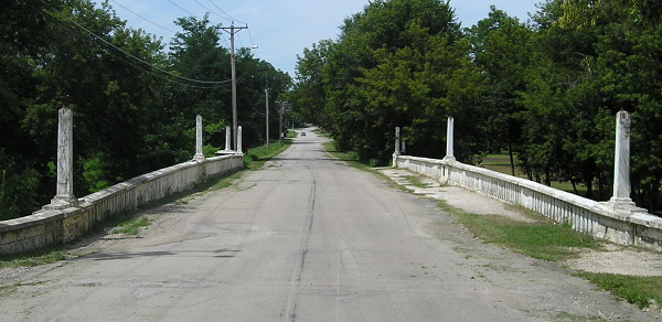
This 1916 bridge, part of US 18 until 1955, is on the west side of Nora Springs. Notice the detail and where lights would have been. The concrete double arch was pictured in the January-March 1917 Service Bulletin. (8/4/15)
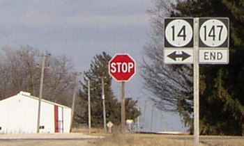
WEST End (2): IA 19, now T24 at B30, Floyd County
The north-south part of IA 53 was changed to a straight north-south road, omitting all the gravel turns mentioned at top, very early. The change was requested in April 1921, in order to cut the distance that would be required to get a connection from Rockford to a hard-surfaced road ("Proposed change in primary road," Rockford Register, April 20). This also eliminated most of Main Avenue in Rockford and brought the change in direction to the east side of the Shell Rock River in Rockford, where IA 147 ended for 37 years. However, 53 remained officially marked to Nora Springs until early 1925.
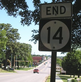
EAST End (2): IA 14, still IA 14, Floyd County
Facing east on 53 (3/22/03)
The only change here is that when IA 14 was paved, it went half a mile north and then east instead of a mile east and then north, eliminating two corners. This was 53's end 1924-26, and 147's end 1926-03.
EAST End (1): IA 19 and 40, now IA 14/Main St. at Business US 218/Gilbert St., Charles City, Floyd County
Facing northeast, but heading east, on 53 (7/31/05)
The Floyd County Courthouse is ahead. The North Iowa Pike, and possibly
original IA 19, used the bridge ahead into Charles City's original Main
Street district and then east on Ferguson Avenue. The overlap with 14
was dropped in late 1924. For more pictures here see the
IA 14 page.
Page created 4/5/20; last updated 8/13/20