

(July 1, 1920-present)
- In 1920, they knew it as: Nothing, despite going through not just every county seat the route touches, but by or a block from every courthouse itself (8 counties). Only the southernmost part, from Lineville to Chariton, had any designation — the Blue J Highway, registered March 23, 1917.
- We know it as: County and gravel roads between Lineville and Corydon, but otherwise present-day IA 14, with assorted hedges nearly all within 2 miles of the present route
- Let's get granular:
- Lineville: Main, 8th, and Washington streets
- This is the only part of IA 14 directly replaced by US 65. The rest of the route northward to IA 2 was added to the state system in early 1926 for the express purpose of making it US 65 later that year.
- There are two sets of construction documents for Lineville. One uses more of Main, instead of angling at the school; the other creates the Brown-to-Washington slope we have today.
- Lineville to Corydon: Birch Road, 40th Street, Cedar Road, 45th Street, Davis Road, 65th St, J54, ??? in Clio, 70th Street, Fremont Road, 75th Street, Garden Road, S22, J46(?), S26, IA 2
- The present J54 curve in Clio was not there in the 1920s. I feel pretty certain 14 would have used the business block of Main Street, but how it would have run from the intersection of Main and Depot streets to the school is unknown.
- Because using J46 would have missed Allerton's business district, 14 more likely came in via the southwest on the gravel road that goes to the corner of Boundary and Spruce streets, then ??? (perhaps past the school) to the corner of Oak Street and Central Avenue (later the south end of IA 40 [II]), then north on Central/S26.
- Elimination of the route south of Allerton made Clio (1920 pop. 299, 1910 pop. 80) perhaps the third town in Iowa to lose its primary road connection permanently.
- IA 2 to Chariton: IA 14, English and East streets in Corydon, Newton Road, 140th Street, 150th Street, Watrous Road, a now-vacated segment of 235th Trail that crossed the railroad, IA 14
- This slightly-more-east route put the CRI&P railroad crossing to just north of the Wayne/Lucas county line instead of the north side of Corydon, yet still missed the town of Millerton, which surprisingly was not incorporated until 1915.
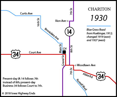
- Chariton: Main Street, Woodlawn Avenue, 8th Street, Ilion Avenue, 7th Street
- Finding an alignment other than the present route (8th and Ilion) came via the construction archive and good coverage in the town's two newspapers at the time.
- Why does southbound 14 stop at Grand Street before going under the railroad? It could be a remnant of when Grand Street carried US 34. The underpass was built in the mid-1930s.
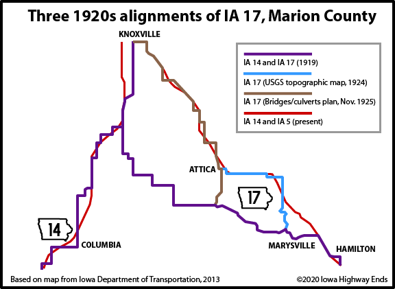
- Chariton to Knoxville: The IA 14 corridor (see map below), but much more stairsteppy, using the following roads: 510th Lane, 234th Trail, 245th Trail, H20, 530th St, 270th Avenue, 535th Street, 280th Avenue, 545th Street, 285th Avenue, 557th Street, 290th Avenue, IA 14, 86th Place, (vacated road in middle of section), 90th Avenue, Virginia Street, 103rd Avenue, Story Drive, IA 14, 112th Place, 115th Place, Quaker Drive, IA 14
- The Marion County portion south of Knoxville was Federal Aid Project No. 7.
- There was a strong push by the then-separate towns of Dallas and Melcher in 1931 to have IA 14 come their way before angling northeast to Knoxville. This effectively pitted those towns against the unincorporated village of Columbia. The IHC stuck with the existing corridor, Columbia is now 1/2 mile away from 14, and Melcher-Dallas got IA 181 instead. ("Columbia routing designated for No. 14," Chariton Herald-Patriot, July 23)
- Knoxville: 130th Place (broken by IA 5/92), Roche Street, Pleasant Street/Business IA 92
- Knoxville to Monroe: IA 14, abandoned roads flooded out by Lake Red Rock including Hempstead Drive and 120th Avenue, then IA 14 again
- The village of Red Rock was southwest of the north end of the Mile-Long Bridge; the village of Cordova about where IA 14 intersects G28. Both were drowned in the reservoir.
- The abandoned pieces here (126th Place and the still-extant bridge over a much-smaller Brush Creek) are from the last part of the highway paved, in 1956 — only to be replaced a decade later by the Mile Long Bridge on November 4, 1965.
- Monroe: County Line Road/S 128th Avenue W, Commerce Street (broken by IA 163), North Street (?), IA 14, a vacated connection to W 36th Street S, IA 14
- Newton: March Avenue, W 15th Street S, S 20th Avenue W, W 4th Street S, US 6/1st Avenue, ???, N 11th Avenue E, E 12th Street N, N 15th Avenue E, E 19th Street N
- Jasper County's grid naming convention is weird because Newton's street naming convention is weird.
- From the corner of 1st Avenue and 1st Street (the southeast corner of the Jasper County Courthouse and the zero-point of the Jasper County road system) to the corner of 11th Avenue and 12th Street, your guess is as good as mine. Either way, that part was out by the end of 1927 at the latest in favor of an all-W 4th alignment.
- The second change in Newton was in 1934, onto the present road north of March Avenue, the present northbound lanes, and Monroe Drive paralleling the C&NW Railroad to the south; the latter now dead-ends but the concrete remains.
- The third change in Newton was in 1942 or 1943, from W 4th Street N to Union Drive and W 8th Street N. That in turn was bypassed in 1965.
- Newton to Laurel: E 19th Street N, N 39th Avenue E, E 28th Street N, N 59th Avenue E, T12, E 64th Street N, N 99th Avenue E, E 60th Street N/Newby Avenue, E67
- 1927(ish) to 1950: IA 14, W 4th Street N, N 99th Avenue E, E 60th Street N/Newby Avenue, E67.
- Laurel to Marshalltown: IA 14, with a squared-off corner at 300th Street and Revere Avenue
- Marshalltown: Center Street, Anson Street, and 3rd Avenue, just like today
- According to a special section of the October 2, 2005, Marshalltown Times-Republican, the Center Street Viaduct opened on July 11, 1951, but the Third Avenue Viaduct is much older, having opened in 1916.
- Between July 11, 1951, and October 12, 1985, IA 14 ran on Center Street over the railyards and Linn Street east. This affected the then-east end of IA 330.
- Marshalltown to Parkersburg: IA 14, including Wiese Garden Road between E27 and the Marshalltown airport, a small frontage road just north of IA 330, Hickory Grove Avenue plus 235th Street at the curves west of Grundy Center, and the correction-line offset at Beaver Roadside Park
- Parkersburg: Westbrook Street, Martin Avenue, IA 14/57, 3rd Street, Railroad Street
- On January 29, 1929, Parkersburg had a vote regarding the location of US 20 (and the part that IA 14 was also on). The Parkersburg Eclipse did not carry the results, called the result "but little understood", and apparently didn't have any effect as the IHC relocated the road from 3rd Street to where it runs today.
- Parkersburg to Allison: IA 14, 280th Street, Martin Avenue (and vacated bridge over West Fork Cedar River), vacated road on east/north sides of farm, Madison Avenue, C45, IA 14
- This non-direct alignment passed by the extinct map dot of Butler Center, which was the county seat until 1881. The railroad went through Allison in 1878 instead and the town vanished in less than five years.
- Allison: Main, 6th, Locust, and 7th streets
- Allison to Greene: IA 14, 130th Street, Bluebird Drive, 120th Street, Lodge Avenue (note the cemetery)
- That last part, just south of Greene, was straightened in 1923 onto present 14 and the abandoned road extending south from the corner of Traer and South streets.
- The 1905 pony truss bridge on Bluebird Drive over Coldwater Creek was closed by county supervisors September 28, 2021.
- Greene: Main, Traer, and 2nd streets, then vacated road north from where 2nd dead-ends
- Main Street is on the west side of the Shell Rock River, but the business corner is on the east: Traer Street between 1st and 2nd.
- Route was shifted from 2nd to 1st, with a railroad overpass, in 1936.
- The present bypass opened in November 1967.
- Greene to Charles City: IA 14, with a "notch" at 210th Street and March Avenue
- Related routes:
- IA 40 (II), spur to Allerton, retained when the segment southward to Lineville was cut
- IA 253, spur to Williamson created when 14 was put on a smoother route between Chariton and Knoxville
- IA 47 (II), spur to Allison created when an overpass was built in 1939 for the Chicago Great Western Railroad on the west side of town. Before that, going from the east junction with IA 3 to the intersection of 47 and 14 required six turns instead of two, and two of those were at the southwest corner of the Butler County Courthouse square.
- Not a related route: IA 396 (I), on the north side of Newton, which was effectively the postwar version of a RISE economic development grant and connected IA 14 with the expanding Maytag factory complex.
- Points of interest:
- IA 14 is the longest north-south primary in the 1920 system to remain more or less intact. Of the 1920 "teens" numbered routes, three are still around but have been severely truncated (10, 12, 13), four were replaced by US highways by 1935 (15, 16, 18, 19), one was renumbered in 1941 (11), and one was replaced in the Great Renumbering of 1969 (17).
- There are a lot of little changes in towns but the only major corridor changes have been the 1926 truncation of the route south of Allerton (with about a third of the dismissed part becoming IA 40), and large straightenings in 1925 and 1949 between Newton and Laurel (with the old parts becoming gravel roads and about 3 miles of E67).
- Many of the highways that cross 14 have been improved while 14 itself has not. Improved roads that now have interchanges with 14 are US 18 (2000/2006), US 20 (2000/2003), US 30 (1996), IA 163 (1999), IA 92 (1978), and US 34 (1961; it's an interchange on the south side of Chariton although the map doesn't show it). All of 14's at-grade intersections with numbered routes except its south end are north of I-80.
- IA 14 was a courthouse-to-courthouse route for 80 years, when the north end was moved slightly southeast (see below).
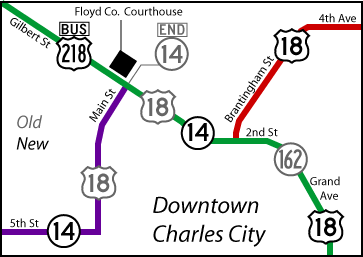
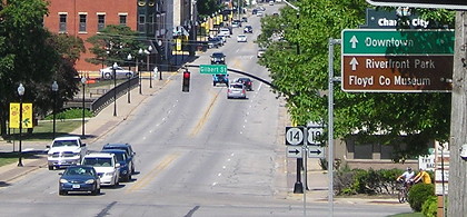
This map is a guide for changes that happened in Charles City in 2006. Old routes are marked with gray shields. For a view of Charles City highways as a whole, see this image.
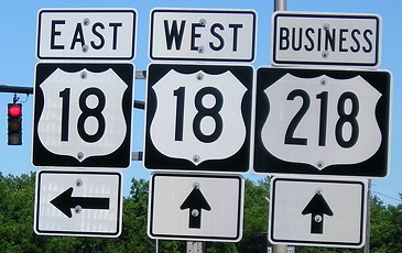
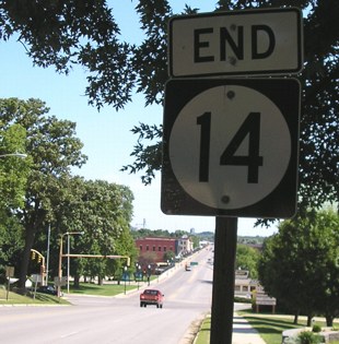
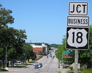
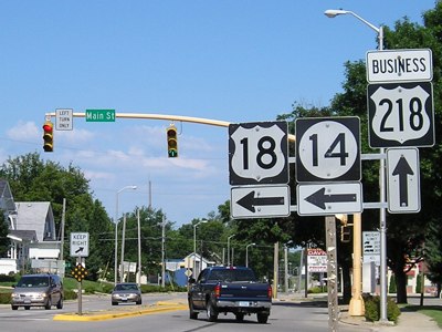
NORTH End: Stoplight, US 18 E/Brantingham St. and US 18 W/2nd St., Charles City, Floyd County
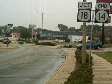
Facing east, but heading north, on 14 (8/13/06)
Photo by Jason Hancock
In May 2005, the AASHTO Standing Committee on Highways approved a change to US 18's route in Charles City: "Beginning at the intersection of present W. Jct. US Route 218/Ia14/Ia27 and an existing facility west of Charles City then southerly and easterly over the facility for 3.57 miles to the E. Jct. US Route 218/Ia27, then northerly over an existing facility for 17.75 miles to the intersection of present US Route 18 in Charles City." (17.75 must have been a typo for 1.75 miles.) On the 2005 map, the red line for US 18 switched to the south side of Charles City. But the changes weren't realized until spring 2006, when new signs were put up throughout town. Because of this, 14's last northbound section goes southeastward and then curves to face straight east as it ends at 18.
At the very bottom of the picture, spray-painted on the street, is written "Jct 18 End 14 Locate." For pictures of this intersection before the changes, see the IA 162 page.
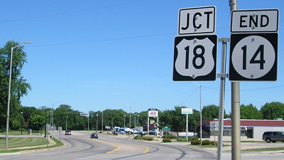
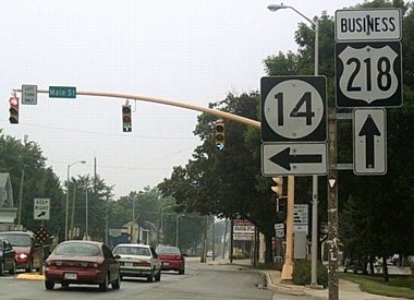
Facing east, but heading north, on 14 (7/16/20)
Facing east, but heading north, on 14 (8/13/06)
Photo by Jason Hancock
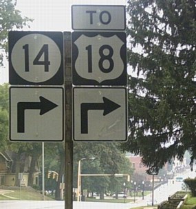
Previously, westbound 18 approached this intersection from the opposite direction, but the eastbound turn for 18 remains the same. Freeman Street goes off to the right.
Facing east, but heading north, on 14 (7/16/20)
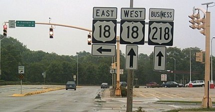
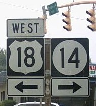
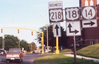
Facing west, but heading east, on 18, and heading north on Business 218 (8/13/06)
Photo by Jason Hancock
Facing south, but heading west, on 18 (8/13/06)
Photo by Jason Hancock
Before the change, west 18 went to the right. The reroute made US 18's route longer, but eliminated a hard turn west of downtown and added a few miles of four-lane.
Facing west, but heading south, on 14 (8/13/06)
Photo by Jason Hancock
Despite the "South" marking, the road turns northwest.
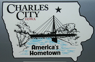
A logo on a city vehicle shows the suspension bridge over the Cedar River. The 1906 bridge at the end of Clark Street was destroyed in the 2008 flood and replaced in 2010. (7/16/20)
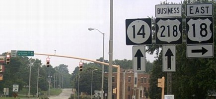
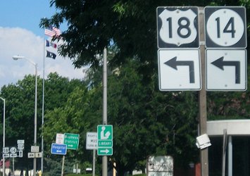
Old NORTH End: Stoplight, US 18/218/Gilbert St. (later Business 218), Charles City, Floyd County
Facing northeast, but heading north, on 14 (7/31/05)
The route of US 18 in Charles City in 1931 was changed to almost the configuration it had right before the bypass (it crossed the river one block farther east), and it's possible that 18 continued straight ahead before then.
Facing northeast, but heading north, on 14 (8/13/06)
Photos by Jason Hancock
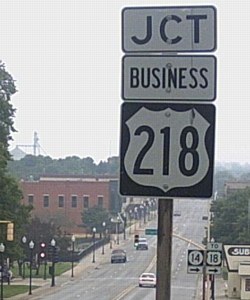
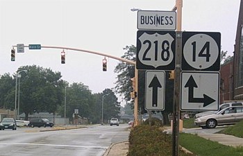
Before the reroute, there was no signage for Business 218 from 14. (Try not to confuse "218" with "To 18".)

Facing northeast, but heading north, on 14 (7/16/20)
Wait ... did they do exactly what I worried about? As we can see from the 2006 photos the "Jct Business 18" is a mistake that appeared some time in the 2010s.
Closeup view of sign/intersection (7/16/20)
Facing northeast, but heading north, on 14 (7/23/02)
Photo by Jason Hancock
Until the US 218 bypass of Charles City opened in August 2000, the street that 14 ended at carried the main routes of both US 18 and 218; as of 2006 it's just Business 218. The road ahead is Main Street, which goes past the Floyd County Courthouse into downtown Charles City without a number.
Facing northwest on 18/Business 218 (7/31/05)
US 18 signage is now gone from the area, as seen in the picture below.
Facing northwest on Business 218, but heading south on 14 (8/13/06)
Photo by Jason Hancock
Facing west, but heading south, on 14 (with 18) (7/23/02)
Photo by Jason Hancock
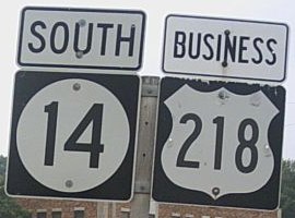
Facing southeast on Business 218 (7/23/02)
Photo by Jason Hancock
Facing southeast on Business 218 (8/13/06)
Photo by Jason Hancock
Facing southeast, but heading south, on 14 and Business 218 (8/13/06)
Photo by Jason Hancock
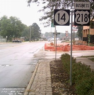
Notice the "Locate 14 Bus 218" written on the street.
Surrounding area information: US 18/US 218/IA 27 interchange
Facing south on 218, but heading east on 18 (sign has been replaced) (7/31/05)
When the Charles City bypass opened, 18 was piggybacked on 14 for the two miles into Charles City — and 14 wasn't truncated even though it had become a redundant multiplex. In 2006, this all changed; 18 was removed and 14 was left alone. (Perhaps this was a consideration all along.)
While it may not make sense on a map, it makes some sense on pavement. IA 14 coming into Charles City is two lanes and a nasty turn with a hill near the end. Business 218, on the other hand, is four lanes (undivided). The 18 post-bypass pre-realignment route going east through Charles City required left-left-right-left (offramp 218, turn on 14, end 14, 18 split from Bus 218). The change means traffic will just go left-right (offramp 218, off Business 218 onto old route).
In light of that, I've wondered whether it might make more sense to reroute 18 between 218 and 63 altogether, by using IA 346. But after further consideration, that's highly unlikely because of the situation through Nashua and past the Little Brown Church, not to mention that the New Hampton bypass was/is probably justified in part by the US 18 traffic.
Facing south on 218, but heading east on 18 (sign has been replaced) (7/31/05)
Due to numbering conventions, the southbound exit here uses 18's numbers, which means that 18 was exiting from itself at the time. Although it would violate the general rule of the lower-numbered route taking precedence, I think using 218's exit numbers around Charles City would have been a better idea since the road is still predominantly north-south. Changing the exit number on the south side of town to match US 18 both ways, making it Exit 218 and having 18 exit from itself again, unites the bypass numbers in relation to Mason City, but now is a greater separation from Waterloo.
Along the route
Abandoned IA 14, south side of Greene (6/26/04)
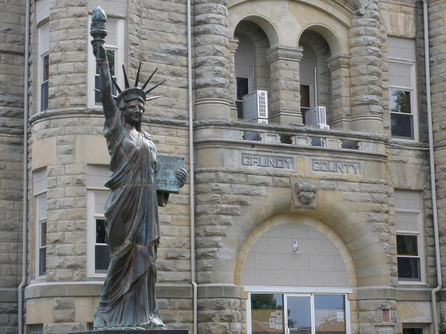
Grundy County Courthouse (1891) (6/3/14)
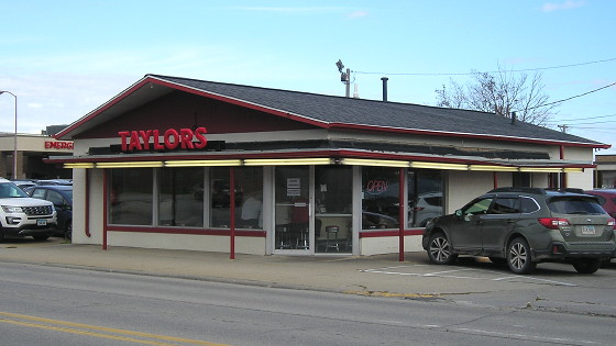
Taylor's Maid-Rite at the corner of 3rd and Church, a Marshalltown icon since 1918 (10/23/19)
Marshalltown owns her own
water works, value half a million. Marshalltown owns her own street
lighting plant. ... Has a wide and busy factory district where the
famous Marshalltown brick masons and cement workers tools are made; a
water governor which goes to the ends of the earth and is in use on
German battleships [oops -Ed.]; contains the largest all steel
furnace works in existence; where the steam traps installed in some of
the most modern hotels of Chicago and of eastern metropoli and the
finest homes on the continent are made and assembled. In this district
everything from a locomotive or a steel viaduct to the little green
pickle in the lunchbox is made or prepared.
— Huebinger's Map and Guide for Iowa
Official Transcontinental Route (1912)
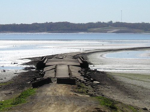
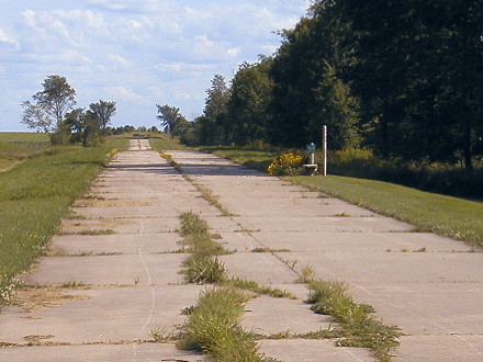
Abandoned 1956 pavement at Lake Red Rock (10/15/10)
SOUTH End: Stop sign, IA 2/Jefferson St., Corydon, Wayne County
Facing south on 14 (6/16/03)
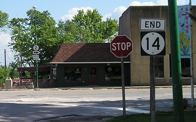
Facing south on 14 (7/11/07)
This is one of the few ends, believe it or not, that are still in a downtown. Street Atlas shows the last block of 14 half a block east of the straight route it comes into town on, because the Wayne County Courthouse block is right in the middle.
Facing west on 2 (6/16/03)
![]()
Facing east on 2, coming into Corydon (7/11/07)
Facing east on 2 (7/11/07)
Just to the right I saw a building frozen in time: It used to be the offices of a car dealership and prominently displays a rack of full-size pamphlets for Chevrolet's entire model line - of 1984. (7/11/07)
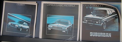
The rack was still there in 2007. (7/11/07)
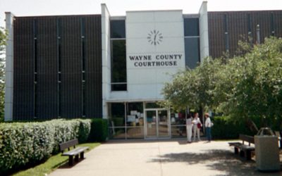
This mid-20th-century courthouse seemed a bit ... different for the downtown and was the only "modern" courthouse I saw on my June 2003 trip though southern Iowa. (6/16/03)
Page created 10/7/02; last updated 10/10/07 5/15/22