
(July 1, 1920-present)
- In 1920, they knew it as: A decent chunk of the Diagonal Trail (more locally, the Iowa Falls, Eldora and Cedar Rapids Diagonal) with the exceptions of bypassing Dinsdale and Garrison (5 counties)
- Only six numbers above 25 hit four-plus counties: 35, 40, 58, 59, 60, and 90.
- We know it as: Parts of US 65, IA 175, US 63, IA 8, and US 218
- Let's get granular:
- Iowa Falls southward, 1920-22: River Street, KK Avenue (now broken by US 20)
- Iowa Falls southward, 1922-24: Oak Street (with a slightly different railroad crossing), US 65
- US 65 to Eldora: D41, O Avenue, 230th Street, OO Avenue, IA 175
- The route was changed from using all-D41 right before the system was established, on the same map realigning soon-to-be IA 5 between Alden and Iowa Falls
- Eldora to US 63: IA 175 except for the following, related to short stairsteps:
- A vacated southward extension of the road to Camp Pine Lake, 235th Street, W Avenue, 240th Street
- Hickory Grove Road and 235th Street (at the curves west of Grundy Center)
- A ¼-mile fragment of P Avenue and then vacated road east on the section line (240th Street)
- A fragment of S Avenue on the east side of Morrison and then vacated eastward extension of 250th Street
- ½ mile of T55 then 260th Street into Reinbeck
- IA 175 to Traer: US 63, but with squared-off corners near Buckingham (Q Avenue/125th Street/PP Avenue)
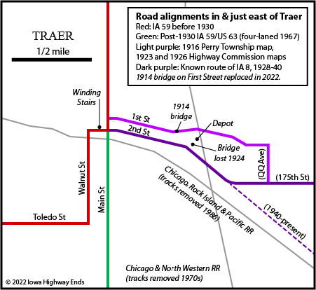
- Traer to Vinton: First Street, 170th Street, QQ Avenue, 175th Street, S Avenue, IA 8, US 218, 22nd Avenue Drive, 58th Street Drive/W D Street, US 218, 4th Street
- Interestingly, for all the efforts that old routes would take to enter nearby towns, I have zero proof 58 ever dipped to go through Dysart. Doing that would have added four corners and two railroad crossings.
- Related routes:
- IA 8 (II), a direct descendant, Traer eastward since 1926
- IA 57, a route that 58 has danced with since the beginning
- IA 90 (II), used for the road east from Grundy Center for six years
- IA 175, which since 1969 has covered the 42 miles between US 65 and US 63 that originally belonged to 58
- See also: Waterloo-Cedar Falls Highway Chronology, and this series of maps covering the various iterations of 57 and 58 in a larger area
| IA 58 endpoint history | |||
| FROM | TO | WEST/SOUTH | EAST/NORTH |
| 7/1/20 |
11/3/24 |
IA 5 (Downtown Iowa Falls) | IA 40/101 (4th St at A Ave, Vinton) |
| 11/3/24 | 10/16/26 |
IA 1 (D41 at US 65) | IA 40 (IA 8 at US 218) |
| 10/16/26 | Summer 1930 | US 65 (D41 at US 65) | IA 14 (IA 175 at IA 14, W junction) |
| Summer 1930 | March 1932 | US 65 (IA 175 at US 65) | |
| March 1932 | August 1932 | US 63 (IA 175 at US 63) | |
| August 1932 | 4/9/35 | IA 14 (IA 175 at IA 14, E junction, Grundy Center) | |
| 4/9/35 | 8/25/56 | US 20 (Hudson Rd at 1st St, CF) | |
| 8/25/56 | 1/1/69 | US 218 (University Ave at Main St, Cedar Falls) | |
| 1/1/69 | 7/1/87 | US 63 (intersection south side Hudson, modified 2013) | |
| 7/1/87 | 11/19/93 | US 20 interchange | |
| 11/19/93 | 7/21/95 | University Ave exit, Cedar Falls | |
| 7/21/95 | Present | US 218/IA 57 interchange | |
WEST End (1): IA 5, Iowa Falls, Hardin County
The south entrance into Iowa Falls is on the route of the Jefferson Highway. The signage of the Jefferson Highway as a Historic Byway in 2019 and Lyell D. Henry Jr.'s excellent book The Jefferson Highway (2016) provide information that, combined with Huebinger's Automobile and Good Road Atlas of Iowa (1912), puts that route in a different place than the early 1920s state maps. IA 58 crossed the Iowa River on River Street, where it met IA 5 at Washington Avenue. However, until 1919 the Hawkeye Highway, renamed the Grant Highway the same year, had come in to Iowa Falls from the north. That, along with downtown being just to the east, puts the more likely end of IA 58 on Washington Avenue at Main Street, the 1920 nexus of primary routes in Iowa Falls.
WEST End (2): IA 1, now D41 at US 65, Hardin County
In 1926, a connector/cutoff route was established between 58 and the Jefferson north of Hubbard. That's IA 134, and you can see more about that on the page for a later iteration of that number. Only when US 65 was paved in 1930 did 58 run straight west from Eldora.
Along the route
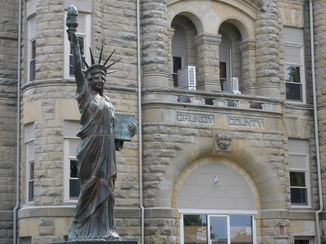
Grundy County Courthouse (1891) (6/3/14)
If one can describe a highway's history as "fun", IA 58 might fit the bill. At one point, we thought there had been a time when the designation was lifted from one place and slapped on an entirely different one, only for me to discover through Highway Commission minutes and seven state maps made during 1932 that it's been continually signed in one place or another.
Fifteen years after 58 was created, it contained a relatively short piece of its original route: Grundy Center to US 63. However, this segment had not been continually signed as 58; between 1926 and early 1932 this road was IA 90 (II). But in a matter of months, 58 was extended back onto 90 and then had its post-1926 segment from US 65 to IA 14 superseded by IA 57. Also, by then it had also been taken in an entirely different direction: northward, to what then was the western extent of Cedar Falls on Hudson Road. Based on a signage diagram from 1967 that was revised before completion, the part of 58 through Hudson was signed east-west. Then, as you can see above, it's had a series of endpoints all around central Black Hawk County. A four-mile segment from the end of the four-lane south of US 20 south to the intersection with Washington Street just north of its present north end is the oldest remaining segment (since 1935).
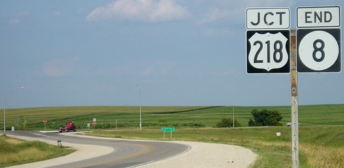
EAST End (2): IA 40, now IA 8 at US 218, Benton County
Facing east on 58 (7/15/07)
The curve wasn't there in the 1920s, but the intersection is at the same section corner as it was at the Great Truncation. The pole had been "End 8" alone; now it has a wide 218 shield. The recycling of IA 8, a single-digit number, to a not-long relatively unimportant route shows the oftentimes randomness of Iowa's system.
For more pictures see the IA 8 page.
EAST End (1): IA 101, now 4th St. at A Ave., Vinton, Benton County
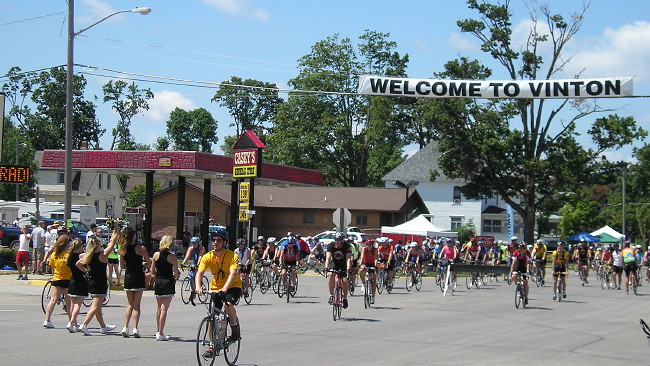
Facing west; IA 40/58 was where bicyclists are (7/26/12)
UPDATE FROM PREVIOUS INFORMATION: Because IA 40 originally used A Avenue south of 4th Street, the 1920-24 end of IA 58 was two blocks behind the camera in downtown Vinton.
Page created 4/26/20; last updated 10/2/22