 and
and
 BUSINESS
NORTH End of both: Interchange, US 75, Sioux City, Woodbury County
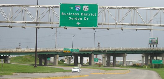
Facing north on Business 75 (9/17/07)
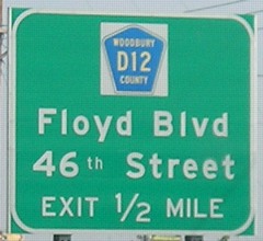
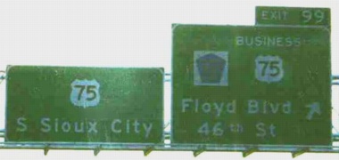
The D12 interchange just south of where new 75 meets the old route still carries the old exit number. Ahead are the bridges carrying the new mainline 75.
Facing southwest, but heading south, on 75 (9/17/07 and 6/12/05)
Thanks to Kurt Berge for finding the secret state highway designation for Business 75!
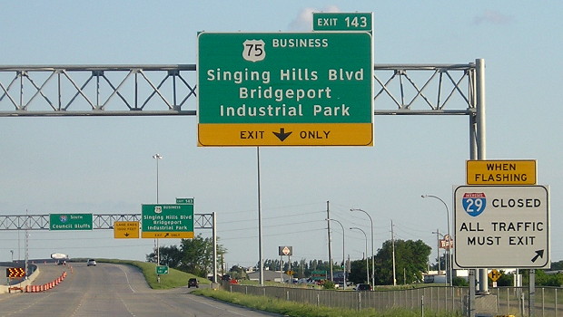
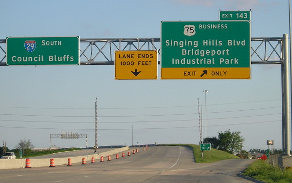
The Woodbury County line is the green sign by the Speed Limit 65.
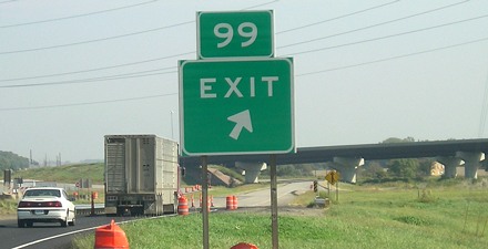
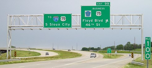
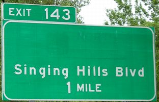
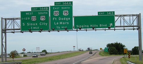
Highway 75 is Exhibit A in the case of why highways occasionally need mile markers reset. In the DOT's, uh, wisdom, in an effort to provide consistency with all of what was left of 75 after rerouting into Nebraska, but not with the entire Sioux City bypass, this is Exit 99. This is 6 miles from US 20 "Exit 4", and about 10 miles from the border. For 75's previous route through Sioux City, the last mile marker was 91, just north of Singing Hills Boulevard. Although it would introduce inconsistency north of here, if the bypasses of 75 and 20 ever become part of an I-429, it would make sense to mark the exits based on the length of the freeway. Exit 97 (28th Street) would be Exit 7, and Exit 99 be Exit 10 (the miles would be in slightly different positions).
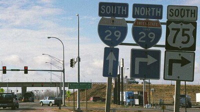
Facing south on 75 (9/20/02)
Photo by Neil Bratney
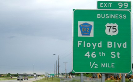
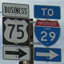
Business 75's north end is a set of partial interchanges, with SB 75 to Bus. 75 a regular exit (above), and NB 75 to Bus. 75 an exit at D12. D12 has an interchange with Business 75 southwest of Business 75's north end - as an east-west road, its only ramps are from northbound 75 and to southbound 75. Compare the left sign to the photo below:
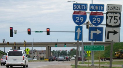
Facing south on 75 (6/12/05)
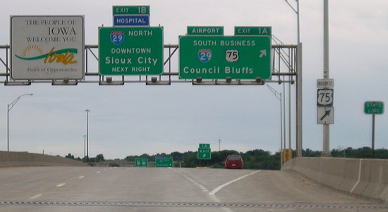
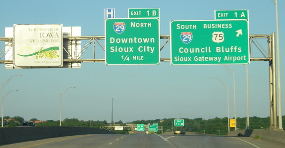
Shortly after the construction of the 75 bypass, there must have been some sort of clamor for directions to Interstate 29, because "To 29" popped up on a lot of BGSs. However, the order of the shields should be "75 to 29" because otherwise it seems to imply that the road is going to 29 AND 75. (Below: Did someone listen?)
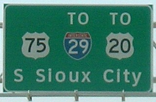
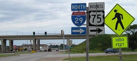
In early 2007, the left sign changed again, now in Clearview. (9/17/07)
Making an Interstate 429 out of this woudn't be easy, but it would be possible. The intersection with County Road C80 in Plymouth County just north of here would have to be blocked off, and then another complicated interchange would have to be built within a mile of here to avoid the unincorporated village of James and turn west. And then there's the problem of development in unincorporated Plymouth County just north of Sioux City (the county line is the city limits). If future plans had been more than just a possiblity or suggestion, the new 75/old 75 split might have been farther north. As it is, though, the I-429 idea was brought up once in 2000 and then never heard from again as the governor of South Dakota expressed no interest.
Surrounding area information: Business 20 interchange
Facing south on Business 75 (6/12/05)
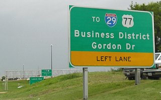
The BGSs at this interchange make no mention of Business 20. Instead, this is the farthest east mention of US 77. It's possible that, like the interchange at the north end, these are new signs to emphasize how to get to I-29.
Facing south on Business 75 (6/12/05)
Surrounding area information: Business 75 split from Old US 75
Facing south on Business 75 (6/12/05)
This is just south of the Interstate 129 interchange. Business 75, formerly 75 south, passed under bridges on the east end of the interchange.
Facing east, but heading north, on Business 75 (6/12/05)
In the distance is the "520 bypass," the secret number for 20's present route around Sioux City. Here 75 turns from Singing Hills Boulevard onto Lewis Boulevard.
Facing south (6/12/05)
After Business 75 leaves the old road, it fast becomes a rural road. Within this picture is all of the last version of IA 970, which was once the designation for old 75 between here and Onawa.
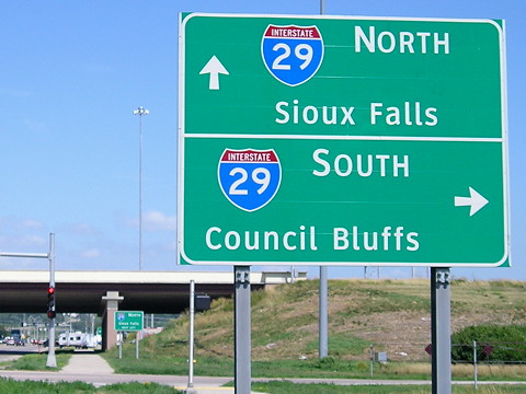
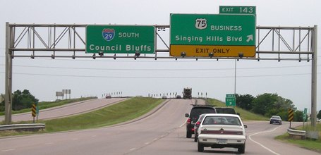
SOUTH End of 376: I-29 exit 143, Sioux City, Woodbury County
Facing west, but heading north, on 75 (November 1999)
Photo by Eric Peterson
The close proximity of 75 to I-29 made it impractical to join the 520 bypass directly. Between 1968 and 1984, southbound 75 turned LEFT at this interchange to join I-29 between here and Council Bluffs. Then, when 75 was moved into Nebraska to suck up US 73, southbound 75 had to go north on 29 for a bit to get to the bridge.
Facing west, but heading north, on Business 75 (6/12/05)
Facing west, but heading north, on Business 75 (6/12/05)
While this is the end of the 376 designation, it appears that Business 75 itself ends at the I-129 interchange.
Facing east on Singing Hills Boulevard (6/4/14)
The large neon sign is not the important part of the picture. The important parts are the "Jct 29" (an endangered species in the state) and the mileage sign on the right.
Facing east on Singing Hills Boulevard (7/17/20)
The standalone sign at right is on the other side of the bridge before the northbound ramps.
Facing north on 29 (6/12/05)
The outline of a US shield and "NORTH" can be seen on the sign if you look close enough. I don't know why they didn't keep the shield and change it to "Business" like was done southbound.
Facing north on 29 (6/12/05)
Ironically, the business route is not shown in the direction (coming into Sioux City) that it would do the most good.
Facing south on 29 (6/12/05)
Facing south on 29 (6/4/14)
Facing south on 29 (6/4/14)
This is near the southern end of the I-29 expansion project in Sioux City. Note the grassy median from 2005 has been replaced with a barrier.
SOUTH End of Business 75: I-29 exit 144, Sioux City, Woodbury County
Facing north on 29, but heading south on Business 75 (6/4/14)
Facing east on 129/20, but heading north on 75 (6/12/05)
Rather than not end at 75, Business 75 retains both ends at its parent with the same wrong-way multiplex 75 had for a mile with I-29 between 1984 and 2001. All the relevant signs were changed to the Business 75 designation. This interchange is just barely into Iowa, as you can see by "State Line" on the right. That, of course, means that this exit is incorrectly numbered and should be the (in)famous Exit Zero. Interstate 129 ends at the gantry in the background. You can see that US 20 and 75 shields are both on the left sign back there.
Facing east on 129/20, but heading north on 75 (6/4/14)
More pictures of this interchange are on the I-129 page.
Page created 1/19/03; last updated 9/9/20