

- In 1920, they knew it as: Elkader Pike (2 counties)
- We know it as: IA 56, part of IA 13, IA 128, and part of US 52
- Let's get granular: The post-truncation changes to IA 56 are almost exclusively within its first three miles of West Union. See the map and discussion below. Original 56 exited West Union via Pine Street, Echo Valley Road, and a vacated extension of Jasper Avenue.
- Elkader eastward, 1920-24 only: Bridge and High streets in Elkader (past the Clayton County courthouse), IA 13, Falcon Avenue (dead end), Fawn Hollow Road (short piece east of Roberts Creek), IA 13, IA 128, US 52, Skyline Drive and vacated arc, X56
- Related route: IA 128, the standalone segment of 56 remaining after the Great Truncation
| IA 56 endpoint history | |||
| FROM | TO | WEST | EAST |
| 7/1/20 | 1922 | IA 19 (Pine St at Main St) OR IA 11 (Main St at Vine St) |
Guttenberg |
| 1922 | 11/3/24 | IA 19 (Pine St at Bradford St) OR IA 11 (Plum St at Vine St) | |
| 11/3/24 | 8/13/31 | IA 13 (Bridge St at 1st St, Elkader) | |
| 8/13/31 | Fall 1940 | IA 11 (Elm St at IA 150) | |
| Fall 1940 | 10/7/53 | US 18 (Pine St at Bradford St) | |
| 10/7/53 | 11/30/82 | IA 150 (Franklin St at IA 150) | |
| 11/30/82 | Present | IA 13 (SE Elkader) | |
1920 WEST End: West Union, Fayette County
I have to make some educated guesses at 56's original route in West Union. Bringing the route as close to the courthouse as possible is typical of a 1920 system highway, and 56 was a route through two county seats. The blue line in the map above is from Huebinger's Map and Guide for North Iowa Pike (1912), and was the first route used for IA 19. It's very possible, likely even, that 56 was signed two blocks west with 19 on Main to intersect IA 11 at the northwest corner of the courthouse square. Based on a story in the West Union Argo-Gazette (August 26, 1931), it appears that sometime before then, 56 was moved southward to use Plum. From that point onward, though, the three endpoint intersections can be pinpointed exactly, assuming 56 was not signed with 18 west of Pine to IA 150.
The courthouse square figures prominently in West Union, and the town nearly lost it. After a fire in February 1922 destroyed the courthouse, Fayette and Oelwein made attempts at stealing the county seat away. The Argo-Gazette called one chapter of the fight "the Oelwein Chamber of Commerce county seat scheme." But the seat remained in West Union, and the current courthouse was built in 1923-24.
WEST End: Stop sign, IA 150/Cemetery St., West Union, Fayette County
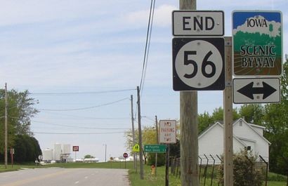
Facing west on 56 (5/18/04)
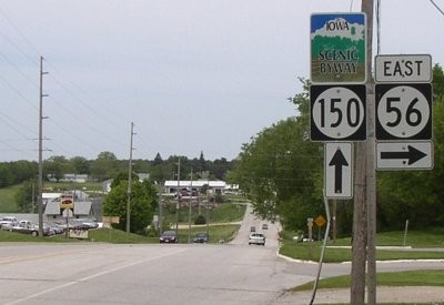
Before it ends, 56 parallels 150 for a mile. There is a 6/10-mile paved shortcut between 150 and 56 1.1 miles to the south, but there's no special signage for it.
Facing north on 150 (7/14/02)
Photo by Jason Hancock
Actually, this intersection is already inside the West Union city limits.
Facing north on 150 (5/18/04)
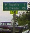
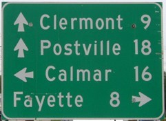
Facing south on 150 / LGS in background ("^ Fayette 7" on top) (7/14/02 and 5/18/04)
Left photo by Jason Hancock
Surrounding area information: IA 150-US 18 intersection
Facing east on 18 (5/18/04)
Facing north on 150 (8/22/20)
Four towns on an LGS is a rarity.
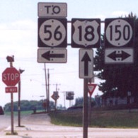
Facing west on 18 (7/14/02)
Photo by Jason Hancock
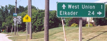
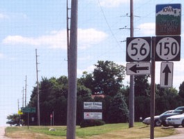
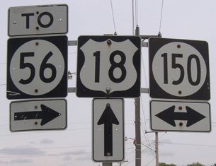
This is the second highway going west on 18 that 18 does not intersect but has a "To" sign. The inclusion of 56 here, like IA 13 to the east, may be due to an old alignment of the route:
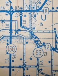
This 1944 map shows 56 paralleling 150 a full mile to the east, turning northwest after meeting County Road X, and ending at US 18 3/10 mile east of 150. The black dot is City Hall. Today, 56 is only half a mile to the east of 150 (along the road between the two). The piece of road between the top of the 56 shield and the bottom of the "F.A." marking no longer exists. It's possible, though unlikely, that 56 was signed with 18 to 150, and "To" signs were placed there (with 18 instead of 150) all along.
Old EAST End: 4-way stop, Old IA 13 N/Bridge St. and Old IA 13 S/1st St., Elkader, Clayton County
Facing northeast, but heading east, on 56 (9/7/06)
This is the main downtown intersection of a county seat, and it's just a stop sign. Clayton County is one of the very few counties in Iowa that doesn't have a stoplight. Behind the camera, 56 makes a turn after one block.
Facing northwest, but heading north, on old 13 (9/7/06)
Facing southeast, but heading east, on old 13 (9/7/06)
This is the first assembly after turning from 56's old end to former southbound IA 13.
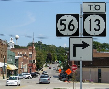
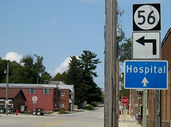
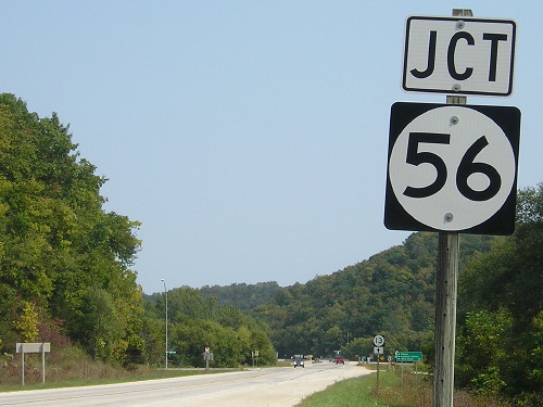
EAST End: Stop sign, IA 13, Clayton County
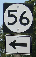
Facing southeast, but heading east, on 56 (9/7/06)
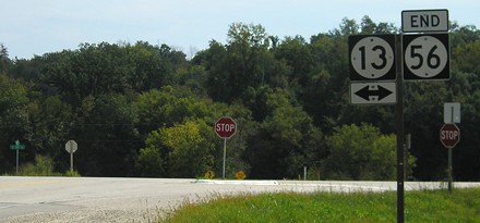
Facing southeast, but heading east, on 56 (9/7/06)
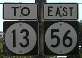
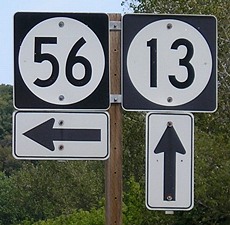
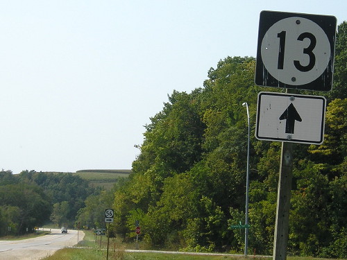
Facing northeast, but heading north, on 13 (9/12/17)
This is the new version of two-digit shields in Iowa, with Series D numerals and less space around the circle. The pole is tilted here, creating some jaggedness on the image.
Facing northeast, but heading north, on 13 (9/7/06)
Look! Scenery! In Iowa!
Facing northeast, but heading north, on 13 (9/1/02)
Photo by Jason Hancock
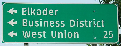
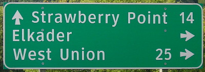
The IA 13 is far enough away that Elkader's not really visible from this intersection, hence the sign here and the "Business District" in the background. There is another intersection northeast of town, at the other end of old 13.
Facing northeast, but heading north, on 13 (9/12/17)
It's curious that West Union wasn't on signs here at the outset.
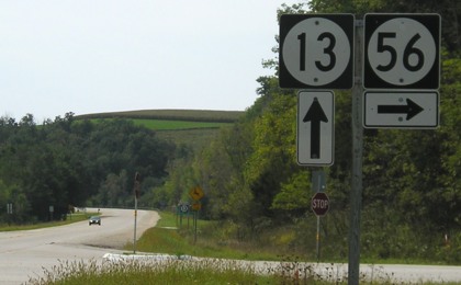
Facing northeast, but heading north, on 13 (9/7/06 and 9/12/17)
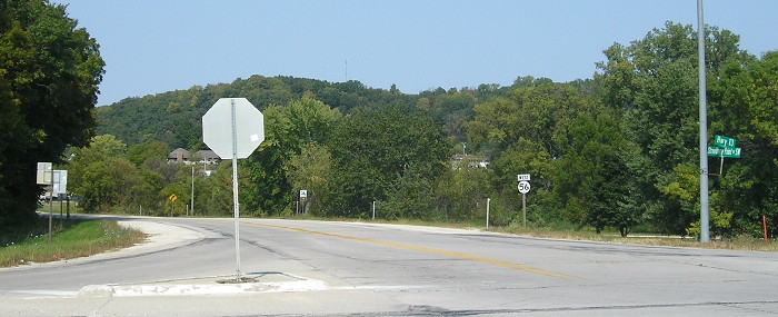
Facing southwest, but heading south, on 13 (9/7/06)
Facing southwest, but heading south, on 13 (9/7/06)
Facing southwest, but heading south, on 13 (9/12/17)
Facing southwest, but heading south, on 13 (9/12/17)
Facing southwest, but heading south, on 13 (9/7/06)
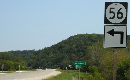
Facing northwest, but heading west, on 56 (9/12/17)
As an original number, IA 56 has connected West Union and Elkader for nearly a century. After 1924, when IA 128 was created from a portion of the route, it's been remarkably unchanged except for right around the endpoints, as discussed at the top of the page.
1920 EAST End: Guttenberg, Clayton County
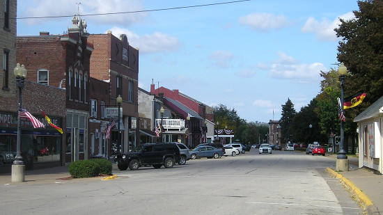
Present US 52 in the Guttenberg area did not exist until 1930. The route mostly used River Park Drive and ended (redundant on IA 20) somewhere in downtown Guttenberg. Downtown is a fun place to walk around, seeing historic buildings on one side and the river on the other. Flags on the streetlights are a callback to Imperial Germany, where an overwhelming number of the early immigrants came from.
Page created 1/11/03; last updated 11/27/06 10/29/20