
(March 11, 1998-August 31, 2016)
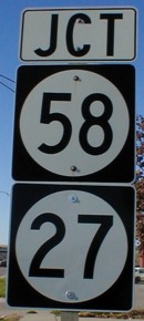
WEST End: Interchange Double devil's circles, IA 58/27, Cedar Falls, Black Hawk County
Facing west on 934 (11/21/01)
University Avenue has had a multi-faceted past. Today's University starts at the Black Hawk/Grundy county line where the old IA 57 began angling northeast (the part west of there was US 20 between 1985 and 2000), levels off west of Cedar Falls' Main Street, and angles back southeast east of College Square Mall, ending at a stoplight with US 63 and 218 in a semi-complicated layout (more on that below). Between the 1950s and 1985, University was split among three roads: IA 57 (from the line to Hudson Road), IA 58 (Hudson Road to Main Street), and US 218 (east of Main). By 1989 only the part east of Greenhill Road was part of any highway, as 57 and 58 were taken off and 218 was rerouted north on Greenhill to a new route east of George Wyth State Park. Between 1992 and 1998 it was a street without a number, one of so many formerly important roads across the country reduced to a simple primary road in the city. After the new 58 was built north of US 20, however, the DOT followed through with what is a rarity — adding a 'new' piece of road to their care (and, based on subsequent events, immediately regretting it). Almost all of 218's University route, except for the 200 or so yards between Main and 58, became part of unsigned IA 934.
For a more comprehensive and visual history of highways in Waterloo see my Waterloo/Cedar Falls Highway Chronology.
Facing west on 934 (11/21/01)
If you look in the far background under the stoplights and the bridge, you can see the poles for the stoplights at the intersection of University and Main. University at Main used to be the north end of 58, which now approaches the area from the south and continues to the newer 218.
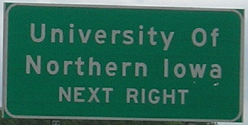
That newer 218, by the time it arrived, removed a lot of traffic from a congested road. A cartoon by Jack Bender — the same Jack Bender who drew the comic strip Alley Oop until summer 2018 — ran in the Waterloo Courier on June 23, 2002, in an article about an exhibit showcasing Bender's art. It's dated October 31, but I have no clue what year. It's titled "Let's play 'University Avenue' — a death-defying, slow-moving game." Spaces on the 'board', in addition to stops, include "Accelerate to beat next light-waste 2 gallons"; "Left turn arrow fails to trip-wait two turns"; and a card that says "Receive a grant to synchronize lights" which leads to "Live happily ever after". (University Avenue itself was only named that around 1970 — uniting 218's route of 27th Street, Waterloo Road, Falls Avenue and Headford Avenue under one name.)
In the late 2010s, University was severely in need of repair. The DOT figured out transfer agreements for Cedar Falls and Waterloo. Cedar Falls immediately set out to rip up the entire road and install FIVE ROUNDABOUTS between Main Street and Waterloo Road, including a pair of them at the ramps with IA 58.
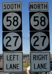
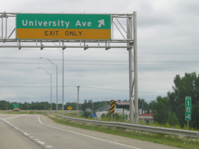
Facing north on 58/27 (7/15/07)
The tenth-mile markers between US 20 and US 218 follow IA 27, so this would be Exit 183 if tabs were added. The 18th Street/Waterloo Road exit would be Exit 184. US 218/IA 57 would be Exit 187.
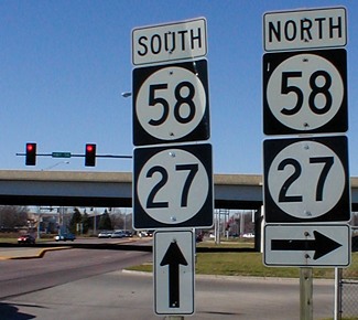
Facing south on 58/27 (7/2/14)
Here you can see the 184-mile marker north of the exit.
Temporary WEST End (2014-16): City limits of Cedar Falls/Waterloo, Black Hawk County
After years of begging and watching University Avenue continue to deteriorate, the state finally unloaded part of IA 934 onto the city of Cedar Falls effective May 12, 2014. In March 2016, the city began a complete overhaul of the street, reducing the mainline to four lanes but also infesting it with roundabouts. However, the 2.83-mile portion in Waterloo remained under state control for more than two years after that. Documentation for turnover was signed in late July and the state letter said "effective at 12:01 a. m., on September 1, 2016", hence my date of August 31 at the top of the page. The $28 million cost works out to $1873.86 per foot.
EAST End: Stoplight, US 63 (and US 218), Waterloo, Black Hawk County
This intersection definitely needs a diagram:
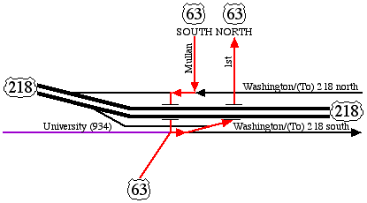
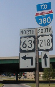
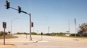
Highway 63 has always intersected 218 on the south side of the Cedar River (and it used to intersect 20 on the north side), but if you had a picture of the intersection in 1987, it would look far different than that in 2002. Before the construction of the Leo P. Rooff expressway, 218 intersected 63 in a (nearly) straightforward manner, coming in from the west on University and leaving on Washington, with 63 sharing some road in between. Today, it's a little, well, interesting. Washington Street is a "frontage road" on both sides, southbound/facing east on the south side and northbound/facing west on the north side. It is signed as 218, as it ultimately ends up there, but has stoplights and is only along the side of the actual highway, which is raised throughout the area.
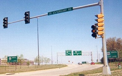
Coming to the intersection of US 63 from University, straight ahead are the lanes for both 63 north and 218 south, a left turn for 218 north and a right for 63 south. That's the easy direction. The difficult part is following 63 north. Facing north on 63 at the University intersection, you have to be in the right lane but must immediately get in one of the two left lanes in order to not end up on Washington Street heading for 218 south. The lanes then split, as 63 goes under the expressway and heads north on First. For southbound traffic, which comes in on Mullan, it merges with Washington and then to continue on 63 you get in the left lane and make a left turn.
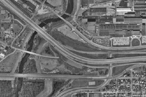
This aerial photo shows all versions of 218 near a branch of the Cedar River. Top to bottom at left, they are the present Leo P. Rooff Expressway, a dead-ending Falls Avenue, and University Avenue. The Falls bridge, built in 1971, is still around to serve a bike path. Highway 63 comes up from center bottom and angles right to intersect University. Before the freeway, 63 and 218 shared a few blocks before splitting at Mullan Avenue (SB) and First Street (NB). For 12 years - 1983 to 1995 - construction in the Waterloo area was almost nonstop, first with bringing I-380 and the US 20 freeway in, then tearing up a swath of downtown for an elevated freeway with at-grade frontage roads and the complicated interchange with US 63. Detours upon detours made traveling in the area far from a picnic.
The following photos are more or less clockwise from nine o'clock, where University comes in, and going around to the north side too:
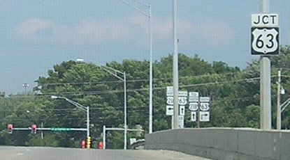
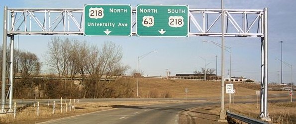
Facing east on 934 (7/15/07)
Facing east on 934 (7/15/07)
There are no shoulders here. There were no signs for 63 on University until recently.

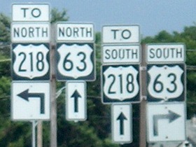
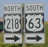
Facing south on 63/Mullan (6/25/02 and 11/20/06)
Price of gas in the photo of the left sign: $1.319. Price of gas in the photo of the right sign: $2.119.
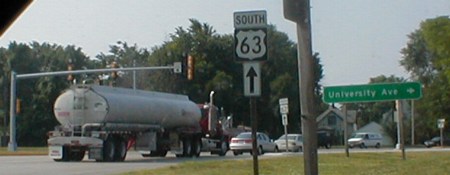
Facing south on 63 (6/25/02)
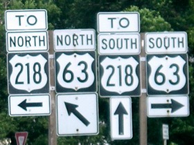
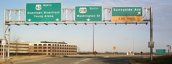
The new versions of these signs are visible in the below photo. With the addition of a sign gantry, the indication that a left turn can also be used to backtrack to northbound 63 has been removed. Also, the straight-right arrows are now diagonal-right.
Facing south on 63 (11/20/06)
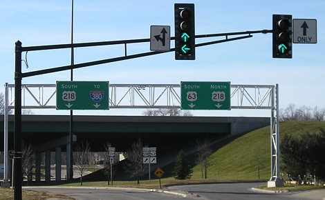
Notice the unorthodox use of green ahead AND left arrows at the Jefferson Street intersection. Shortly after going right, southbound 63 takes a left while northbound 218 goes ahead. The semi in the below picture followed southbound 63.
Facing east, but looking south, on the 218 SB offramp to 63 (6/25/02)
Southbound, there is only one exit for 63. Northbound, north and south are split into two.
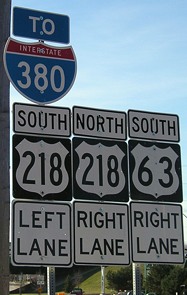
Facing north on 63 (12/24/06)
Photo by Jason Hancock
New signs were installed on 63 in 2006.

Facing east, but heading north, on 63 (12/24/06)
Photo by Jason Hancock
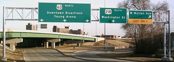
Facing northwest (on 63) (June 2002)
An overhead BGS on current 218 can be seen right of center. Traffic is directed to University via 63 on 218 NB and Greenhill Road on 218 SB.
Facing north on 63 (June 2002)
As noted above, northbound 63 must turn right and immediately get in the left lanes. The red car will end up on a road that joins other lanes and becomes Washington Street southbound. The stoplight in the foreground is for University. Compare the signs in the background to the below picture.
Facing northeast, but heading north, on 63 (12/24/06)
Photo by Jason Hancock
Facing east-southeast, but heading north, on 63 (12/24/06)
Photo by Jason Hancock
The Mullan Avenue on this sign only goes south of the interchange. This is in the approximate area that southbound 218 would have encountered southbound 63. (SB 63 would then go behind the camera with NB 218.)
Page created 5/31/02; last updated 4/7/20