Facing northwest
(and conflicting accounts thereof)
According to the website "America's Roof" (link kaput), the geographic center of the state of Iowa is at 42.0667 degrees north latitude and 93.4 degrees west longitude (decimal), or 42°4'N, 93°24'W. If correct, then the point is near the unincorporated community of Fernald, in Story County, near the junction of county roads E29 and S27. This point is typical of central Iowa, surrounded by fields made flat from the multiple glaciers passing on top of the state.
Facing northwest
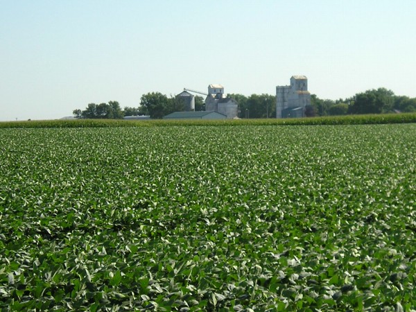
The elevator in the background is in Fernald. The center of Iowa, according to the above coordinates, is in the northeast corner of this section, where the beanfield ends, just down and to the left of the bin. (Of course it's in a field. What did you expect for the middle of Iowa?)
Many sites mischaracterize this point. It is NOT, as indicated in multiple places, five miles northeast of Ames. In reality, if we take the center of Ames to be the intersection of Lincoln Way and Grand Avenue, the geographic center is about 11 miles east and three miles north of that point, or 11.4 miles east-northeast of Ames (the square root of [11x11]+[3x3]=130); or 3.9 miles northeast of 6th Street and Lincoln Highway in Nevada (the square root of [2.5x2.5]+[3x3]=15.25). Even were we to use the easternmost edge of Ames (13th Street at I-35), Fernald is still eight miles away.
According to the website About.com, the geographic center of the state of Iowa is at 41°57.7'N 93°23.1'W, or 41.962°N 93.385°W. That discrepancy of a tenth of a latitude degree translates to about 7.22 miles - not exactly a small step away. This point is eight miles almost due south from Fernald, still near County Road S27, 4.5 miles north of Maxwell. Since this point is 13 miles southeast of Ames (despite being labeled as 5 miles NE on the site), it would seem to have less credibility, but on the other hand, it is a bit northeast of the old village of Iowa Center. As a point of reference, in much of Story and Marshall counties US 30 runs just north of the 42° line.
Theoretically, this could be solved by simply finding the midway point between the northern and southern borders of the state. Of course, this is tricky because of one obvious and one not-so-obvious problem: Lee County dips down, and the rest of the border is not straight. (See my page on Iowa's southern border).
So I'll try the next best thing: Find the halfway point between the borders excluding Lee County. The north border is really easy: 43°30' north. The southernmost point of the rest of the southern border, near Athelstan, is 40°35'15". Midway between these is 42°4'38". Placing that with 93°23'31", about halfway between the two longitude points in the other figures, gives a location that, quite interestingly enough, is slightly northeast of the first point listed above!
The southernmost point in Iowa, west of Keokuk and now on the wrong side of the Des Moines River, is at about 40°22'33"N, 91°27'30"W (40°22.55, 91°27.5). Halfway between this latitude point and the north border is approximately 41°56'16" (41.938°). You might know where this is going. That's right, this point is just a bit south of the point listed above in the third paragraph. In both cases, near Fernald and Iowa Center, only tight zooming reveals the differences.
Obviously, the main difference in these points is latitude; longitude differs only by .015 degree (54 seconds, or 5454 feet - a mile plus half a football field). Which to believe? Well, the geographic center of the contiguous United States cares about Maine and Florida. The geographic center of Missouri should be relevant to its bootheel and northwest extension. So why wouldn't the position of Lee County drag the position of the center down?
Page created 11/1/05