Muscatine highway chronology
These maps show the highway evolution in the city of Muscatine and the immediate area. US highways are in red, state highways in purple, business routes in green, and four-lane highways in thicker lines. The thick blue line is the Mississippi River.
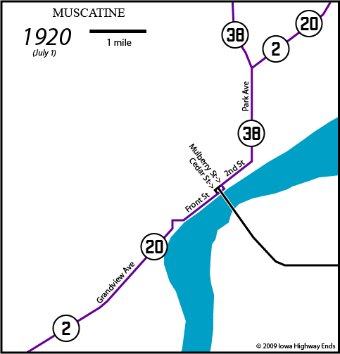
| NOTE:
At this time, the toll bridge did not have an assigned highway
number. It goes over Front Street. The traffic flow was likely
arranged such that Illinois-bound traffic would not have to make
a left turn onto the bridge, instead turning from (either
direction of) Front onto Cedar, then right on 2nd, then right
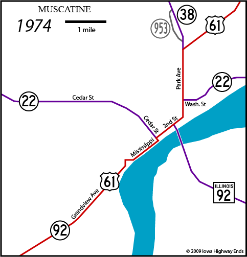
onto the bridge. End 38: Bridge Northbound Park Avenue: Eastbound 2, northbound 20 and 38 August 18, 1924: IA 20 placed on new riverside alignment east of Muscatine to Davenport January 6, 1925: IA 38 truncated to IA 2 junction, which at this time is north of the city October 16, 1926: US 61 replaces IA 20; IA 2 truncated at Grandview (south junction US 61); IA 22 replaces IA 2 east of Muscatine |
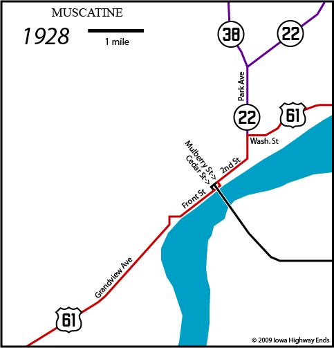
| NOTE:
Illinois proposed a state highway running west from Taylor Ridge
IL to Muscatine in 1928 as part of a $100 million statewide
construction bond issue. It was completed by the time of the
1930 Illinois map. End 38: Junction IA 22 Northbound Park Avenue north of Washington Street: Eastbound 22 January 7, 1931: IA 2 re-extended to Muscatine July 8, 1931: IA 22 extended westward Before 1936: IA 38 re-extended to downtown Muscatine |
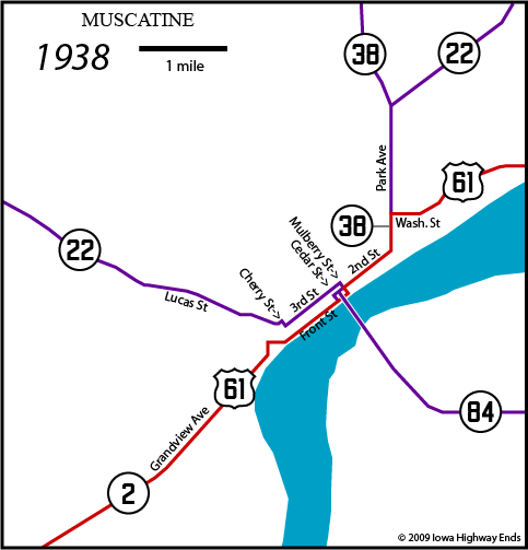
| End 38:
Bridge Northbound Park Avenue north of Washington Street: Eastbound 22, northbound 38 Sometime between 1938 and 1943: IA 22 realigned onto Cedar Street February 1, 1939: IA 92 replaces IA 2 and IL 84 |
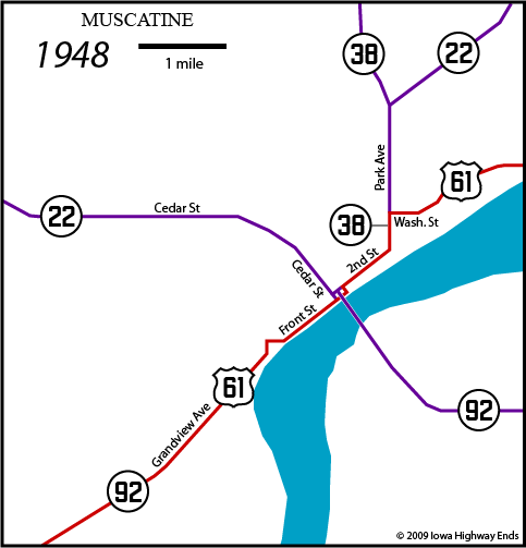
| End 38:
Bridge Northbound Park Avenue north of Washington Street: Eastbound 22, northbound 38 June 1-October 12, 1956: Bridge closed October 23, 1958: US 61 and IA 22 swap places east of Muscatine January 1, 1969: IA 38 re-truncated to Y intersection at US 61 December 2, 1972: New Mississippi River bridge opens Unknown: Front Street renamed Mississippi Drive Unknown: New IA 38 bridge over Mad Creek leaves behind old segment called IA 953 |
| End 38:
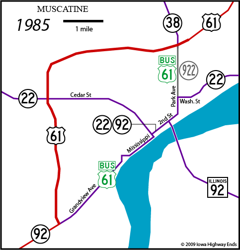
Junction US 61 Northbound Park Avenue north of Washington Street: Northbound 61 1980: IA 953 turned over December 12, 1984: US 61 bypass opens. You would think that 22 and 38 would have been changed at the same time, but records indicate differently. The state of the roads in 1985, below, was a short-lived deal. |
| NOTE:
The 1974 Muscatine inset on the state map clearly shows 61 using
Cedar to transition to 2nd...and then the inset disappears for
two decades. Maps through the early '00s don't show a switch to
Mulberry, but aerial photos from 1994 show that the change
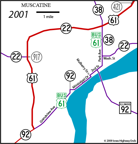
happened before then. End 38: Junction US 61 Northbound Park Avenue north of Washington Street: Northbound Business 61, secret IA 922 June 3, 1986: IA 22 rerouted onto bypass, IA 38 re-extended south to new bridge; small segment of 22 between bypass and city limits becomes IA 917 July 1, 1987: Bridge becomes toll-free November 2000: US 61 opens to four lanes northeast of Muscatine |
| End 38:
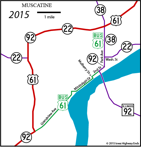
Bridge (Junction IA 92) Northbound Park Avenue north of Washington Street: Northbound Business 61/IA 38, westbound IA 22 July 2002: US 61/IA 92 opens to four lanes southwest of Muscatine July 1, 2003: IA 917 and IA 421 (short segment of 61 left behind when four-lane opened) turned over to county October 22, 2008: Hershey Avenue (County Road G28) interchange opens on bypass, halfway between IA 22 and 92 (not shown) Fall 2014 (officially July 1): IA 92 removed from Grandview Avenue/Mississippi Drive and put on bypass with US 61 and IA 38; IA 38's south end does not change |
| End 38:
Bridge (Junction IA 92) Northbound Park Avenue north of Washington Street: Northbound Business 61/IA 38, westbound IA 22/92 |
Page created 2/11/09; last updated 9/4/19