Iowa's northern and western borders
(or, "The Land Between Three Rivers and a Funky Diagonal")
By Jeff Morrison, iowahighwayends.net
When Florida became a state on March 3, 1845, it created an imbalance between free and slave states in the Union. Since about the beginning of the 19th century, free and slave states were admitted to the Union in pairs, the most notable pair being Maine and Missouri in the Missouri Compromise. Michigan and Arkansas followed about 15 years later, and eight years after that it was time for a new round. With Florida's admission, Iowa was the next candidate for statehood.
At the time, Iowa Territory extended all the way up to the British Empire, in what today are Manitoba and Saskatchewan, bordered on the west by the Missouri River and the east by the Mississippi River. It included eastern South Dakota, three-fourths of North Dakota, and more than half of Minnesota. But as with most territories, the final boundaries for a state would be pared down from the original territory.
Many sources put a diagonal in the first state border proposal made in 1845. A line would extend from the mouth of the Big Sioux River at present-day Sioux City to the mouth of the Blue Earth River just west of present-day Mankato. From there, the Minnesota River would be the border up to the Mississippi River, and then the Mississippi would be the state's eastern border. (Hence, the subtitle above.) In the following discussion about the borders, I will often refer to present-day sites and highways, to provide a sense of location. Keep in mind, though, that had either of these borders been accepted, the history of those cities and highways would be very different. Maybe they wouldn't exist at all.

Here's an expanded version:

This graphic shows how the diagonal would have cut off Iowa's northwestern corner. Interstates in Minnesota that would be in "Iowa" are also on this map. Black dots are in the proposed state of Iowa, gray dots out. The line seems to go almost directly over the southwestern and northeastern corners of O'Brien County, which would put half the town of Primghar inside Iowa and half outside it. (In addition, today's Sioux City would likely have a really skewed street grid.) The line would also go right through West Okoboji Lake and near today's west junction of US 71 and IA 9. In retrospect, though this portion of Iowa was virtually unsettled by whites at the time, such a line would cut off some very productive farmland.
Prominent dissent: Author Mark Stein includes no mention of this diagonal proposal. Instead, he says that Territorial Governor Robert Lucas proposed borders that would include ALL of Minnesota south of the Minnesota River plus that portion of what is now South Dakota east of the Big Sioux River to its source with a line east to somewhere northwest of Big Stone City, SD. (Geographic quirk: The Big Sioux flows south through western Sioux Falls then turns back north to I-90 before going east and south again - that would make for a weird border dip!) This would have given the state a big lobe to the northwest plus, again, the southern half of what is now the Minneapolis-St. Paul metro area.
Congress rejected the first proposal, whatever it was - perhaps because of the diagonal when the township-and-range system was well-established, but that's only my speculation. It sent back a new one - one that chopped off about a third of the present state. Sources agree that the western border was not the Missouri River, and that the proposal went north into present-day Minnesota, but beyond that, there are discrepancies that vary enough to be completely confusing. Descriptions I have seen:
- "two counties into Minnesota and no farther west than Des Moines" (1)
- "60 miles east of the Missouri River and slightly north of the current Minnesota border" (2). Depending on where you measure from, this could be a short distance west of modern-day IA 148 or the same line mentioned below.
- "The western boundary was to be essentially a northern continuation of Missouri's western boundary (the meridian passing through the mouth of the Kansas River). Iowa's northern boundary was to be the line of latitude passing through the confluence of the Minnesota and Blue Earth rivers." (3) This line marked Missouri's entire western border until 1837, when the northwest corner was officially added to the state, and in Iowa it passes just to the east of IA 4's route between Emmetsburg and IA 175; IA 25 would be entirely east of this line. This line would make sense along the idea that Iowa should be no narrower than Missouri. A geographic problem with this description is that a whole-number line of latitude does not pass through the river point. However, 44 degrees 10 minutes is remarkably close, so that may be the intended line.
- "Congress presented for the approval of the people of the Territory a new western boundary which passed from north to south on a line about forty miles west of Des Moines. The northern boundary was on a line with the juncture of the Blue Earth and St. Peter's [Minnesota] Rivers, in Minnesota." (4) But then this description seems to contradict itself: "Had Congress prevailed, Iowa to-day would be but little more than half as wide from east to west as it is, and would extend thirty miles farther north, into Minnesota." A line 40 miles west of Des Moines (the confluence of the Raccoon and Des Moines rivers) would be somewhere in the vicinity of Panora - practically right on top of IA 4 in that area. It's about two-thirds, not half, as wide as the current state, even when measured from the Burlington area. Des Moines itself is west of the state's vertical center line. Not only that, but the Blue Earth's mouth is about 42 miles north of the present-day northern border, not 30, and 44° N is 34.5 miles north.
- 94 degress West longitude and a line passing through the confluence of the Minnesota and Blue Earth Rivers. (5) An undetailed map of this plan, created for an Iowa Public Television documentary, puts the west and east forks of the Des Moines River just to the west of this line, southeast of present-day Humboldt. But it also has a problem: It places the Blue Earth's mouth to the east of the 94-degree line. In reality, the mouth is about 1.6 miles west of this line. The point of 43°10' N and 94° W is the intersection of Main and Broad in downtown Mankato - between 1000 and 2500 feet away from the Minnesota River.
- The extension of the former Missouri border as mentioned in the third bullet point (despite the fact that it had stopped being Missouri's western border north of Kansas City nearly a decade earlier) and a line NORTH of the Minnesota/Mississippi confluence that could quite possibly be 45° N. (6) Today, this line of latitude is approximately a mile and a half south of the MN 36 expressway through the suburb of Roseville and on Broadway Street in Minneapolis. Downtown Minneapolis is about three miles south of this line.
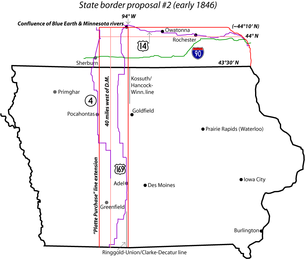
The map above draws out the options as best I understand them, with the exclusion of the last one. A north-south red line labeled "'Platte Purchase' line extension," the farthest west, is the continuation of the "meridian passing through the mouth of the Kansas River"; a second red line is 94° W. A vertical pink line marks the middle option, and a horizontal pink line shows 44° N. IA 4, US 14 and 169 are drawn in, as well as I-90, to help illustrate where the state lines would be. Kossuth County's eastern border and a line of four counties in southern Iowa - right by the easternmost line on either side - are also drawn for illustration. Coincidentally (or not), 94° W is also at or near the dividing line between "P" and "R" county roads.
Given these lines, I think either the Platte Purchase extension or 94° W would have been the line in question. Trying to negotiate the latter border after the actual paths of the rivers were found, though, would be awkward to say the least. Putting a tri-state corner so near but not at a river, with one state shut out of the riverfront, probably would not be a good situation for commerce and development. A shift west of even one minute, to 94°1' W, would solve this problem and give "Iowa" a small piece of the Minnesota River riverfront, while 94°3' would put the Blue Earth's mouth in the state. Had either plan been implemented, neither Burlington (the original territorial capital) nor Iowa City (the second territorial capital) would have been centered in the state; perhaps consideration would have been given to the town of Prairie Rapids, which would later change its name to Waterloo.
Regardless of where the proposed border was actually drawn, when confronted with this too-much-off-the-back state outline, Iowans said, "Adopt that? In a pig's eye!" (This is a Minnesota joke: Around the time Iowa's statehood was being planned, a village was founded on the Mississippi River across from what would have become Iowa under the first plan. This village was called Pig's Eye, and is better known today as St. Paul.) It was back to the drawing board again, and this time, taking 43°30' N as the northern border for the entire way from the Mississippi to the Big Sioux was judged as acceptable. The south line remained in dispute for a few more years - for that, see my page on the Sullivan Line.
The Minnesota Historical Society, unfortunately, gets its facts wrong in more places than one.
This map is on a 1992 marker at the US 59/MN 60 Minnesota Welcome Center, about four miles north of the state line. The relevant text on the marker says: "When Iowa prepared to join the union in 1844, its constitutional convention voted to set the new state's northern boundary along the line [45° N] shown above, including the confluence of the Minnesota and Mississippi rivers. ... Iowa's northern border was [later] fixed on the latitude of 43.30, and when Iowa became a state on August 4, 1846, the future state of Minnesota's southern boundary was set even before the Minnesota Territory was organized."
The only other place that I have seen 45° considered as a line for Iowa's northern border is in Stein's book, and even there it's not explicity labeled as such. If 45° had been considered, it would have been very early in the process, possibly in 1844 as mentioned on the marker; otherwise, only southeastern Minnesota was even under consideration. But I DO know that that statehood date is flat out wrong; Iowa became a state on December 28, 1846.
Sources:(1) Irwin, Ann and Reida, Bernice. Hawkeye Adventure. Lake Mills, IA: Graphic Publishing Co. Inc., 1966/1975, p. 202-3. This happened to be my sixth-grade Iowa History book.
(2) Iowa Public Television, "Iowa Pathways: The Path to Statehood." Accessed May 20, 2007.
(3) Wikipedia version of "Iowa" as posted on answers.com. Accessed May 20, 2007. In turn, that webpage cites Meining, D.W. The Shaping of America: A Geographical Perspective on 500 Years of History, Volume 2: Continental America, 1800-1867. New Haven, CT: Yale University Press, 1993, p. 437-8. This information (as of May 2007) is not on the "Iowa" page on Wikipedia itself (and had a book not been cited, it would not have been listed here).
(4) Sabin, Henry and Sabin, Edwin. The Making of Iowa (Chapter 3: The Birth of a State). Chicago, IL: A. Flanagan Co., 1900, republished online by the Iowa GenWeb Project.
(5) Iowa Public Television, "Iowa Pathways: The Path to Statehood: Western Boundary Debate." Same site as source #2, but with a visual aid: A segment of "The Path to Statehood," The Iowa Heritage: Program #3, Iowa Public Television, 1978. (RealPlayer) The fact that the same website has two different border markings shows the confusion here.
(6) Stein, Mark. How the States Got Their Shapes. New York, NY: HarperCollins Publishers, 2008, p. 95-100. (Stein discusses the southern border without using the words "Honey War." What's up with that?)