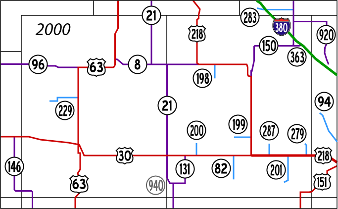
Highway Chronology of Tama and Benton counties

These maps show the highway evolution in Tama and Benton counties and the immediate surrounding area. State spur highways are in light blue, state highways in purple, US highways in red, and interstates in green.

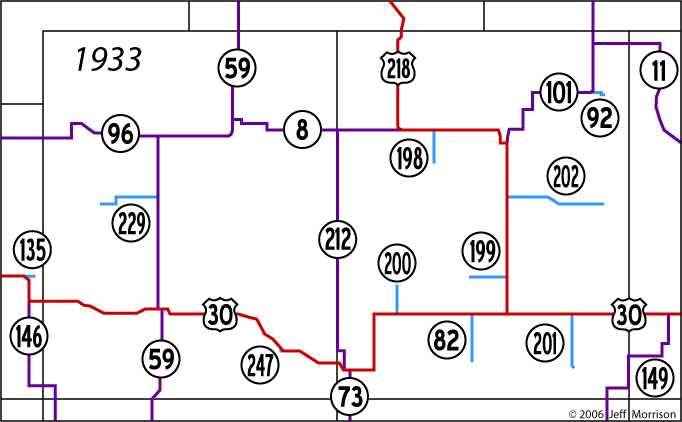
October 16, 1926: US 30 replaces IA 6; US 218 replaces IA 40 to Youngstown Station. IA 13 and 58 truncated; IA 150 and IA 8 replace them.
April 18, 1927: US 30 rerouted in Belle Plaine to use 13th Street from 8th Avenue westward. The change will cause George Preston to move his later-famous gas station.
1928: IA 146 extended north from Grinnell to US 30
1929: IA 146 changed to enter Tama County instead of go south from Gilman
January 7, 1930 (signs don't change until March): IA 149 replaces IA 150
Summer 1930: Paving of IA 59 realigns route west of Traer
December 1, 1930: IA 96 extended west to IA 14. Article in Tama Northern (Gladbrook) mentions west end same as current end, but maps show 96 one mile south of present alignment until late 1930s.
Also December 1, 1930: IA 198, 199, 200, 201, and 202 created in Benton County
January 8, 1931: IA 212 created between Belle Plaine and Dysart; IA 229 created
Spring 1931: IA 73's north end moved from 8th Ave. at 13th St. in Belle Plaine to 7th Ave. at 13th St., which will later be IA 21/131 intersection
July 1931: "Chelsea cutoff" on US 30 bypasses town; IA 247 created August 5 for Chelsea
August 1931: US 30 realigned between IA 59 and east edge of Tama, taking it out of downtown Tama and off the Lincoln Highway bridge

December 5, 1933: IA 73 extended northward to Dysart, replacing all of 212
May 22, 1934: New IA 212 created to replace 73, because of a new IA 73 in western Iowa. However, signs will not be put up for months.
July 18, 1934: "212" straightened northwest of Belle Plaine to follow county line
September 15, 1934: IA 212 signs replace IA 73 (Marengo Pioneer-Republican, Sept. 20: "Road Between Belle Plaine, Marengo Is Now No. 212")
September 25, 1934: IA 21 replaces IA 212 between Dysart and a point south of Belle Plaine; signs put up two weeks or so afterward (Belle Plaine Union, Oct. 4: "Victor, B. P., Dysart Road Now No. 21")
December 1, 1934: IA 59 replaced by US 63 (Toledo Chronicle, Dec. 13: "Primary road No. 59 will become a federal highway" - shown on state maps dated Dec. 1)
1935: IA 171, 279, 280, 283 and 318 created; IA 149 diagonalized northeast of Walford
Late 1930s: IA 8 alignment between Traer and Dysart finalized
October 26, 1937: US 30 straightened; IA 212, 131 replace it to west, east of Belle Plaine
January 1, 1938: US 218 extended southward; goes east with 30 to Cedar Rapids
February 1, 1939: IA 363 replaces 92
July 1939: IA 64 routed along US 30

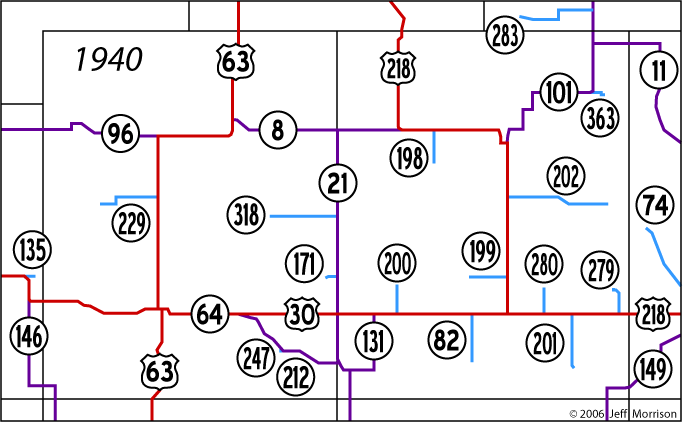
1941: IA 150 replaces IA 11; IA 74 created
1942 or 1943: IA 101 straightened north of Vinton
1948: IA 96 paved west of Gladbrook, skirting Gladbrook on the south
1953: Paving of IA 146 shifts part of road one mile east
September 1, 1954: New US 30 opens between 63 in Toledo and east edge of Tama
September 25, 1954: US 30 realigned between Le Grand and Tama; IA 146 extended north two miles; first IA 135 decommissioned
October 8, 1954: Stop signs added to 30 at new 63 intersection (for two weeks, only traffic on 63 stopped; two accidents occurred in 36 hours Oct. 4-5)
Mid-October 1954: New IA 135 commissioned for Montour

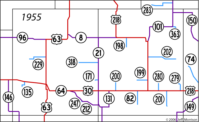
1956: Paving of IA 74 causes IA 399 to be created to serve downtown Palo; route of IA 283 probably straightened with paving
1958: Entire route of IA 201 shifted one mile east with paving
Early 1960s: US 218 realigned around Vinton; IA 202 straightened
1962: IA 135 realigned in paving; goes northwest from Montour instead of northeast
1963: IA 247 decommissioned
1964: IA 399 decommissioned
1966: IA 280 becomes IA 287; IA 74 becomes IA 94
1967: IA 202 decommissioned
January 1, 1969: New road between Waterloo and IA 8 becomes part of IA 21; IA 64 leaves

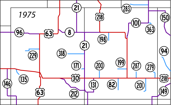
May 27, 1980: Tama County Supervisors accept IA 135, 212, and 318. Article in Traer Star-Clipper neglects to mention 171, but it is also turned over.
1980: Benton County spurs trimmed to the city limits of towns they serve
August 14, 1984: I-380 completed to IA 150; IA 150 rerouted; IA 363 extended; IA 101 decommissioned; IA 920 created
September 12, 1985: Remainder of I-380 in Benton County opens
September 19, 1985: US 151 replaces IA 149 between US 30 and US 6
1985: US 30/218 freeway completed around Cedar Rapids
1992: US 30/218 four-laned between IA 201 and freeway
November 1999: US 30/218 four-laned between US 218 and IA 201

2001: East-west segment of IA 131 turned over
July 1, 2003: All Benton County spurs, IA 94, IA 229, IA 283, IA 363, IA 920, rest of IA 131, and IA 940 decommissioned
November 2004: Le Grand bypass opens; four lanes to IA 146 in June 2005
November 1, 2010: New 30 opens to four lanes between US 63 and the east end of the Tama bypass, creating a tiny duplex with US 63 that lasts three weeks
November 23, 2010: New 30 opens as two lanes from casino to US 63
2011: Future alignment plans for US 30 between Tama and US 218 shift four-lane route either above or below the section line

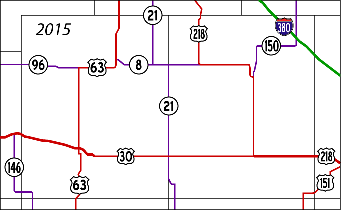
This map shows the near-future state of highways in Tama and Benton counties and their immediate surroundings. Notice how bare it seems compared to some of the years above.

Maps on this page © Jeff Morrison 2005-06

Page created 6/26/05; last updated 7/21/11

To Iowa Highway Ends Annex

To Iowa Highway Ends Index