Tama County in the Iowa Legislature
After getting glimpses of other state legislatures and their (sometimes literally) odd seat counts, the majestic simplicity of Iowa's Legislature becomes something that isn't to be taken for granted. The Senate has double the members of the House. Two House districts fold exactly into one Senate district.
Yet it wasn't always that way. After Baker v. Carr and Reynolds v. Sims in the 1960s, allowing judicial challenges of reapportionment and creating the "one man, one vote" ideal, Iowa had to re-evaluate its election process. In 1968, the legislative chambers were fixed at their present sizes - 100 in the House, down from 124, and 50 in the Senate, down from 61. (See also the official "Legislative Guide to Redistricting in Iowa" PDF.) County lines were now subordinate to the demand that each representative and senator serve as close to the same number of people in their respective chambers as possible.
But enough about the big picture. Here's how all of that affected a little piece of east-central Iowa, specifically Tama County and friends. (Still reading? Either I know you personally or probably should!) The maps below are not only what DID happen, but what MIGHT HAVE happened, as proposals got derailed along the way.
Where'd the basemap come from? I'm so nerdy that I saved the FAILED 2001 redistricting map (the "orange map," nicknamed as such because that was the color the Legislative Services Agency used to draw the lines). From there, it was a matter of a lot of deleting and coloring. However, if the district extends beyond the counties surrounding Tama County, I simply make a note of it.
Trivia point: Neither Tama nor Benton County has a Washington Township. Every surrounding county does.
1970
The first attempt to pare down Iowa's Legislature seats started out well enough, but managed to make everyone mad: 77 of the 185 legislators were paired up in districts, the plan still hewed closely to county lines, and then the Supreme Court struck it down in February 1970. By that time it was too late for a fix and everyone was going to have to live with the map for one election. It was just as well, because they'd have to be redrawn after the 1970 census anyway...
1970s
Supreme Court 2, reapportionment commissions 0: A plan approved in July 1971 was struck down because it allowed too much population variance between districts. The Supreme Court redrew the districts in the spring of 1972 and Tama County was torn into three directions in both the House and Senate. Watch this space.
1980s failed plans
The Legislative Services Agency put these online in conjunction with the redistricting proposal in spring 2011. Two of them got rejected by the Legislature. Watch this space.
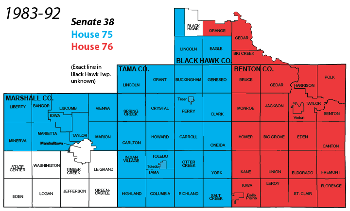
With the third plan created in 1981, Tama County stayed intact. I am unsure of the boundary splitting up precincts of Black Hawk Township of Black Hawk County, because the statewide map put online in 2011 isn't quite straight in the area. I have a paper copy of the 1990s districts (see below) that shows a division of Black Hawk Township precincts, which isn't a straight line as shown above. However, I'm not going to try to duplicate it, and Hudson's city limits were smaller then.
This is about as straightforward as you can get. The Tama/Benton/Iowa state Senate district was the southernmost part of U.S. House District 2. A Grundy/Butler state House district went up the west side of this congressional district, which was notable for the double-incumbent Dave Nagle-Jim Nussle matchup in 1992 after Iowa lost a House seat.
Iowa State University note: Helser Hall, State Gym, and the athletics facilities south of Lincoln Way were in House 62, while Friley Hall and everything else were in House 61.
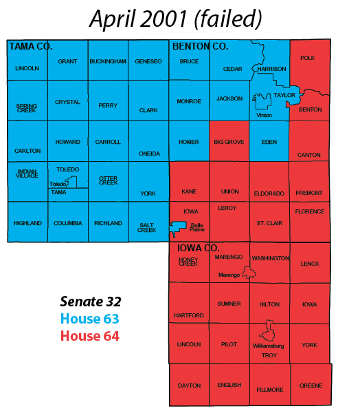
The first attempt, the "orange map," got a rather fast heave-ho, in part because it threw U.S. Reps. Jim Leach and Jim Nussle into the same district. This three-county area bears a strong resemblance to the previous map, right down to being the southernmost part of a U.S. House district that stretched to Minnesota. Belle Plaine and its surrounding township would have been separated. The second attempt, the "purple map," below, was approved in a one-day special session in June (and Jim Leach still had to move).
Iowa State University note: Perhaps the most interesting aspect of this failed and mostly forgotten plan is that it would have split the ISU campus in two even more than the 1990s. Beardshear and Curtiss Halls, sitting within eyesight of each other on Central Campus, would have been in different state House districts. Roughly the western third of the main campus and everything south of Lincoln Way would have been in House 41, with the rest in House 42. Imagine different campaign signs depending on whether you were in Friley or Maple-Willow-Larch.
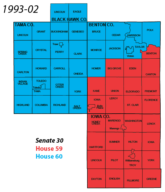
For the first time since the end of 1982, Tama County is split up not only into separate House districts but separate Senate districts as well. These four House and two Senate districts made up the eastern half of U.S. House District 3. To the north, U.S. House District 1; to the east, House District 2; in Marshall County, House District 4. This was the site of one of the state's party switches in the 2000s: Rep. Dawn Pettengill of Benton County switched from Democrat to Republican.
Iowa State University note: Of the seven plans created and rejected from 1981 to 2011, this is the only one that kept the main campus and athletics facilities in the same House district.
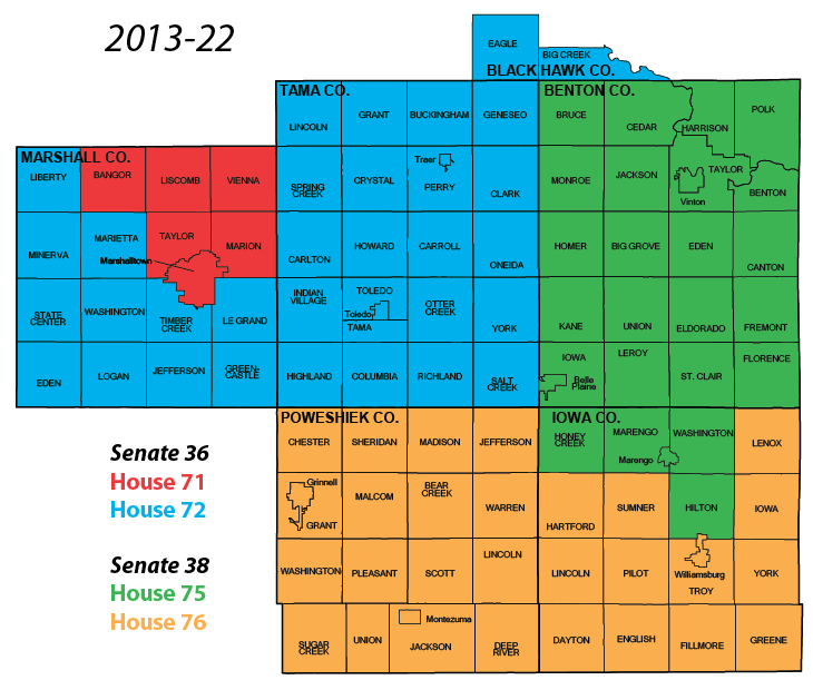
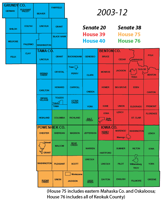
Tama County is intact once again and, for the first time in a long time, shares a state senator with Marshalltown. The official plans from the LSA shaded each Senate district in pastel colors rather than using a white map with thin House and thick Senate lines. (If we'd had to go to a second plan, what would we have called it? I guess since the actual lines were blue this was the "blue map.") Big Creek Township sticks out but brings La Porte City into the district.
In creating the newest maps, I stumbled upon an event that has happened rarely in Iowa in the past 100 years: A county abolished a township - for reasons other than "the city consumed it." In the 1980s map, you can see that Iowa Township in Marshall County, centered around Albion, was the centerpiece of a 150-year-old arrangement that broke up the standard four-by-four grid of a square county. On April 14, 2009, the Marshall County board of supervisors did something about that (PDF, page 3), rearranging the four surrounding townships to conform to the township-and-range system and getting rid of Iowa Township in the process. The 2010 census was the first event to be affected. As a byproduct of this event, the town of Liscomb is now entirely outside of Liscomb Township and the handful of houses that are what's left of the village of Marietta aren't in Marietta Township. Marietta Township had actually grown in the 1970s, being given about six square miles of the already-tiny Linn Township that had not been absorbed by the city of Marshalltown.
I left the Benton/Iowa/Poweshiek Senate district visible here because these five counties make up the southwest corner of Iowa's northeastern U.S. House district (1st) for the 2010s. Grundy County is now in the southeast corner of the northwest(!) (4th) district. (Meanwhile, eastern Mahaska County, but not Oskaloosa, is now part of a state House district extending down to Missouri.)
Page created 4/28/11; last updated 5/18/11