(July 1, 1920-May 4, 1935)
- In 1920, they knew it as: The Ayr Line (get it?) from the Missouri state line via Mount Ayr to Winterset, the I.O.A. Short Line between Winterset and Martensdale/Des Moines and Winterset Road to downtown Des Moines, and Iowa's northern share of the Wilson Highway from Des Moines to Minnesota (10 counties).
- Until the Wilson Highway was registered on September 13, 1918, the more-or-less straight road north of Ames did not have any overarching designation. Huebinger's Automobile and Good Road Atlas of Iowa (1912) says the corridor was the Des Moines, Mason City, and Minneapolis Highway from Des Moines to Ellsworth.
- We know it as: US 169, gravel roads between Afton and Winterset, IA 92, IA 28, Army Post Road, SW 9th and 7th streets on Des Moines' south side, Grand Avenue, US 69
- Let's get granular:
- State line to Mount Ayr: US 169, P27, 292nd St, 160th Avenue, 290th Street, P32, J43, US 169, 240th Street, 205th Avenue, 235th St, 215th Avenue
- Mount Ayr: Henderson, South, Taylor, Jefferson, Grant, and Columbus streets
- Segment heading out of town to west was moved to 208th Avenue and 228th Street (gravel north of IA 2 connecting with Madison Street) in 1932.
- The route through downtown was likely in place until 1952! A direct connection was built to IA 2 in 1941, but the in-town route remains on the 1945 county map.
- The Grant Street segment was more north-south than the present, as we can see by the property line of two houses.
- This city route still had a railroad crossing. The CB&Q, which is now the Ringgold Trailway east of US 169, ran in the area between the south side of the present-day high school and the ball diamonds.
- Mount Ayr to Afton: US 169, H45/Dutcher Street and East Street in Arispe, US 169, 230th Street, Oriole Avenue, US 169
- Afton: Browning, Kansas, and Douglas streets
- A driver in the 1920s would have seen the former Union County Courthouse in the Afton square, used as a school after the county seat moved to Creston in 1890.
- Afton to Winterset: Palomino Drive, 170th Street, Quail Avenue, H17, Redwood Avenue/Fawn Avenue, G61 (¼ mile), Elderberry Avenue, 290th Street, Fawn Avenue, 280th Street, Homestead Avenue, 275th Street, Carver Road, 270th Street, Kiowa Avenue, 265th Street, US 169, Knoll Ridge Trail, Carver Road
- Winterset: S 4th Avenue, Summit Street, John Wayne Drive, E Court Avenue
- IA 15 and IA 24 shared the road from the intersection of 4th and Summit to Martensdale.
- Winterset to Patterson: Norwood Avenue, IA 92, 206th Street, Quail Ridge Trail and vacated road to east marked by trees, Rustic Lane (across now-gone RRX), long and short driveways, IA 92, more angular now-gone road east of Settlers Lane, IA 92
- Patterson to Bevington: 8th, North, 7th, and Long streets; now-gone RRX just southeast of the IA 92/Long intersection; vacated road south of IA 92; now-gone RRX at Wildrose Avenue, then a vacated road along the section line east to the county line; Warren Avenue
- An alignment hugging the Chicago, Rock Island & Pacific Railroad wasn't built until 1926.
- Bevington to Martensdale: Warren Avenue/10th Avenue, Jesup Street (broken by I-35), 20th Avenue, Jersey Street, 30th Avenue, Inwood Street
- The route in Bevington of Linnane Drive, 2nd Street, and Grant Street (extension of 2nd on the Warren County side, now the south edge of the paved area at Kum & Go) was used from 1926-31.
- Martensdale to Norwalk: Iowa Avenue, 40th Avenue (now abandoned), IA 28, vacated road on section line north of Hoover Street, Harding Street, 43rd Avenue, vacated segment northeast of Prole, Gear Street, 50th Avenue, vacated road from corner of 50th/Fulton running on the south side of Linn Grove Cemetery, IA 28, 55th Avenue, Fairfax Street (and extension east and north of present 28 to about the G24 intersection), Wright Road (Norwalk)/Coolidge Street (Warren County)
- Norwalk northward: Main Street, High Road, Cherry Parkway (and extension due north), IA 28, old IA 28/SW 42nd Street (now broken by both IA 5 and the Des Moines Airport), the section line formerly known as Army Post Road
- By the late 1930s, there was a big curve from SW 42nd to Army Post, about where the runway is.
- A quarter-mile-long strip of original Army Post, bypassed in 1998, was being used as an elongated parking lot until 2018.
- Army Post Road between SW 42nd and SW 9th streets carried IA 15 (1920-26), 28 (1926-59), 60 (1959-69), and 5 (1969-98).
- Des Moines: Army Post Road, SW 9th Street, Clifton Avenue, Thomas Beck Road, 7th Street, Grand Avenue, E 14th Street
- From the intersection of 7th and Grand in Des Moines to the intersection of Duff Avenue and Lincoln Way in Ames, IA 15 overlapped IA 1/Jefferson Highway.
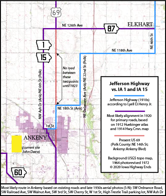
- Ankeny: Ankeny Boulevard (same as NE 14th St), SW Ordnance Road, SW Railroad Avenue, SW Walnut Avenue, SW 3rd Street, SW Cherry Street, W 1st Street, High Trestle Trail parking lot, NW Ash Drive
- Lyell D. Henry, who wrote a book on the Jefferson Highway, has a different routing between Ankeny and Elkhart, and every state map of the time shows a straight line, but this route matches the Huebinger 1912 county map. The 1914 county map and a 1921 construction document clearly indicate that part of US 69 north of what is now NE 18th Street did not exist until the early 1920s. See map down page.
- Yes, a parking lot. Satellite photos clearly show part of the lot near the water tower is an old street; this was changed in the 1990s.
- Ankeny to Ames: NE 6th Street, NE 126th Avenue, US 69; 1st Street, Main Avenue, 5th Street, and 5th Avenue (dead end) in Huxley; US 69
- The original route stuck to the half-section line and passed Lincoln Cemetery on the west side. Today's gentle angles around is all that’s left of the Des Moines-Fort Dodge interurban line and the extinct map dot of Midvale.
- Ames to Blairsburg: US 69, with Dawes Drive and US 69 Access Road on the north side of Ames; US 69 from there to D20/Old US 20
- After 1926, the south end of 15 was Grand Avenue at Lincoln Way (where it met US 30) or Lincoln Way at Duff Avenue (where 30 met US 65).
- AMES. Hotels — Arlington, Am. $2, Ames, Am. $2, Lawton House, Am. $1.50. — 1912 county map
- In early county maps, the north-south road weaves around present US 69 from Gilbert to Jewell, but all the state maps show a straight line, and the creation of IA 115 to Story City in 1923 concurrent with a change in city limits leans toward this being the case for the primary road.
- Blairsburg: D20, Kellogg Avenue, 2nd Street, Lake Street, 210th Street, US 69
- Confirmed by the March 12, 1923 Webster City Freeman. The 1914 map marks the route north as Quinn Avenue and 180th Street, but that's not what the article says.
- Wright County: US 69, 310th Street, Taylor Avenue, R59, Walnut Street in Galt, 240th Street, Taylor Avenue, 220th Street, US 69; Main Street and 4th Avenue in Belmond; 130th Street, US 69 but following the section line and hopping to the other side of the CRI&P railroad to near the county line
- I strongly suspect that's the original way through Belmond, straightened and avoiding RRX's by 1926.
- Goodell to Garner: US 69, 200th Street, Sioux Avenue, 225th Street (county)/Lyons Street (Garner), State and 3rd streets in Garner, a railroad crossing where US 69 is today, and a road aligned with Cottonwood Drive southwest of the present intersection with US 18
- The overpass was built in 1935, about the same time IA 15 became US 69; it also carried US 18 until 1952.
- Garner to Lake Mills: US 69, 4th Street and Secor Avenue in Forest City, US 69, 380th Street, 175th Avenue, 410th Street, 183rd Avenue, 420th Street, 190th Avenue, 440th Street, 210th Avenue, the corner driveway behind Lake Mills Motor Sports
- Lake Mills to state line: US 69/Main Street, Mill Street, S 5th Avenue, Western Street, R74, 480th Street, 230th Avenue, joining A14/510th Street at state line and going east on state line to Main Street in Emmons.
- Related routes:
- US 169, state line to Winterset
- IA 70 (I), the spur to Macksburg, which started as one of the shortest routes in the 1920 system but was lengthened significantly using part of old 15 when the road between Afton and Winterset became the road between Thayer and Winterset
- IA 92, Winterset to Martensdale
- IA 28, which would take over 15's route from Martensdale to downtown Des Moines, its only independent segment between Winterset and Ames
- IA 46 (II), a later designation for SW 9th Street
- US 69 north of Ames, which replaced IA 15 in 1935
- IA 72, the westernmost part anyway, which took over the route through Galt for a few years after 15 was straightened north-south
- IA 262, the eastward spur to Galt, after IA 72 was straightened east-west
- IA 296 (II) (unsigned), SW 42nd Street between Army Post Road and the north side of Norwalk, bypassed in 2000. The part north of IA 5 serves the Des Moines Register's printing press; the part south of IA 5 is an abandoned four-lane road today.
- IA 972 (unsigned), old US 169 south of Winterset
NORTH End: Minnesota state line, now State St. at Main St., Emmons MN, Worth County IA/Freeborn County MN

USDA/NRCS photo (1939)
From the intersection of 230th Avenue and 510th Street east to Main Street in Emmons, it depends on who's in charge. Emmons has a handful of houses and remnants of a used-car dealership on the Iowa side and its downtown is the block north of the state line.
Along the route

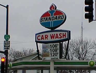
This was the only Standard in Ames, along with five Amocos. It was replaced by a BP in December 2002 or January 2003. Ironically, this station had been locally known as "Butch's Amoco". (11/29/01)


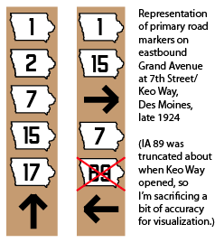
This is intended to show what it could have looked like if markers were painted on poles at the downtown intersection of 7th and Grand at the end of 1924. The 1925 state map, the first with insets, is the key to this.
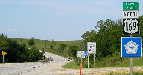
SOUTH End: Missouri state line, Ringgold County IA/Worth County MO

Facing south on 169 (8/21/06)
The state line connection started at the section line, just a bit to the east of today's US 169, but by 1926 it was at the present location.

Facing north on 169 (8/21/06)
For more pictures see the US 169 stateline page.
Page created 5/12/20; last updated 5/4/22