"What happened?"
"The town was bypassed to save ten minutes of driving time."
--Disney/Pixar's "Cars" (2006)
Four-lane highway openings in
Iowa by year and month
Credits for this page include Jason Hancock's
website, Iowa state maps, newspaper articles, and the Iowa Interstate
Completion Map available at the iowainterstate50th.com website (all
interstates prior to 1982). Multiple entries in a month are listed in
order of specific day of the month if known; italics at the end indicate
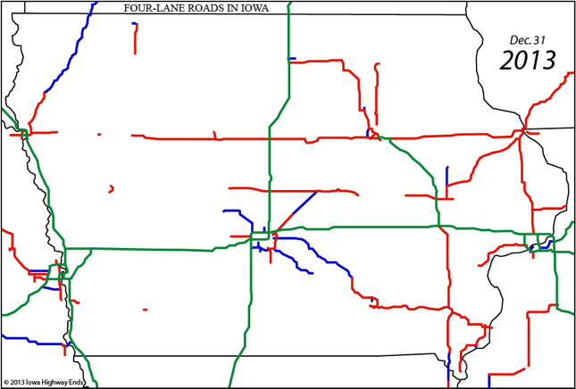
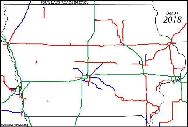
expected openings. Interstate highways are shown in green, US highways in
red, and state highways in blue. This map does not show multilane roads of
a primarily urban nature, e.g. old US 218/University Avenue through
Waterloo and Cedar Falls.
Early dates and unknowns
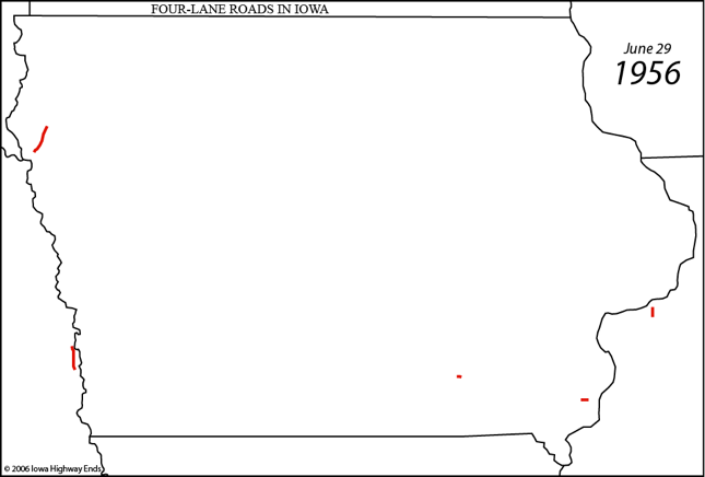
- 1942: US 34, Middletown to West Burlington (bypassed Nov/05)
- November 1949: US 75, north side Sioux City to Hinton - oldest rural
four-lane segment in Iowa in use as of 2006, but wholly reconstructed
and leveled out in 2019
- December 1949: US 75, Hinton to Merrill - will be reconstructed and
leveled out in 2023
- June 1954: US 34, 2 miles east of Ottumwa (narrow median) (bypassed
Oct/06)
- Unknown, late 1950s: US 20, segment in Dubuque
- June 29, 1956: Eisenhower signs law to create interstate highway
system
1957
- Unknown: US 61/151, Grandview Avenue to south split (Dbq) (north half
w/US 52) (narrow median)
- June: US 75, Merrill to Le Mars (northern third bypassed Nov/06)
- December: US 77/US 20 [I-29], Hamilton Boulevard to Gordon Street,
including interchange at bridge
1958
- September: US 20, Nevada Street in Waterloo to Elk Run Heights
(bypassed Sep/85); I-80, Douglas Avenue to west mixmaster (DM); I-35,
Douglas Avenue to Cumming [G14] (#65)
- October: I-35, Cumming to IA 92; US 20, 3 miles east of Moville
- November: I-29, US 77/IA 12 (#151) to US 20 (#147B); I-35/80, Douglas
Avenue to Merle Hay Road (DM); I-29, US 30 to US 75 [IA 192] (#56);
I-35, IA 92 to north of Osceola [IA 152]; US 34, 3 miles west of Agency
(was 2 lanes since Sep/55; bypassed Oct/06)
1959
- August: US 20, 3 miles west of Dubuque
- November: I-29, SC industrial area [Business US 75] (#143) to IA 140
[IA 141] (#127); I-35/80, Merle Hay Road to US 69 (DM); I-80, US 6 [G30]
(#75) to IA 25
1960
- July: I-29, US 20/77 to SC industrial area
- August: I-35, north of Osceola to US 34
- Second half of year: US 30, Dow City to Denison (most removed late
1970s)
- September: I-80, US 71 to US 6 (#75); I-80, IA 25 to US 6 [F60] (#100)
- November: I-80, US 69 to US 6 (#159); I-35, US 69 to east mixmaster
(DM); US 169, north junction IA 5 [IA 7] to US 20 [Business 20]
- December: I-80, IA 38 (#267) to US 61; I-280, I-80 to US 6
1961
- Unknown: US 63, US 218 to near IA 412 [US 20]; IA 415, south city
limits of Ankeny (old IA 160 junction) to I-35/80
- October: I-29, IA 141 (#127) to IA 175
- December: I-235, Cottage Grove Avenue to Keosauqua Way; I-29, South
Dakota to US 77/IA 12
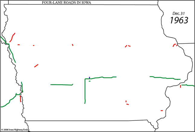
1962
- August: I-80, Herbert Hoover Highway [F44] (#249) to IA 38 (#267)
- October: I-80, US 6 (#159) to IA 14
- November: I-80, IA 14 to IA 146; I-80, IA 1 to Herbert Hoover Highway;
US 20, 2.5 miles near Holstein (part w/US 59)
1963
- Unknown: US 63, north side of Ottumwa to Court Street
- November: I-235, Keo Way to East 6th Street; I-80, US 218 [old IA 965]
(#240) to IA 1
1964
- Unknown: IA 163, west side of Pleasant Hill to a bit east of Pleasant
Hill
- June: US 34, west of Ottumwa to Church Street
- October: I-80, IA 146 to US 218
- November: US 20, Sioux City to Moville; US 30, Ogden to Ames; I-80, US
61 to US 67
1965
- Unknown: IA 163, Pleasant Hill to IA 316
- November: I-35, US 30 to I-80; US 34, 3 miles near US 71
- December: I-80, US 59 to US 71
1966
- September: US 63, Church Street to south side of Ottumwa
- October: All of I-480; I-80, US 67 to Illinois
- December: I-680, I-29 to I-80; I-80, I-680 to US 59; US 6 (#100) to
west mixmaster (completes link from I-29 to I-35); I-235, 31st Street to
Cottage Grove Avenue and East 6th Street to University Avenue
1967
- Unknown: US 59/IA 141, north junction IA 141 to US 30 (map marks IA 4
[IA 39] to 30 until mid-'90s)
- December: I-235, 63rd Street to 31st Street and University Avenue to
east mixmaster; I-35, US 20 [D28] (#144) to US 30; I-29, IA 175 to US
30; US 61/151, near Maquoketa Drive in Dubuque to Dubuque Airport; US
34, east junction US 63 to Roemer Avenue (Ottumwa)
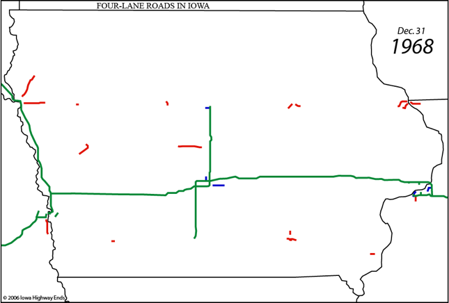
1968
- July: I-80, Madison Avenue to US 6 (#8) (CB)
- August: I-74, I-80 to US 6
- October: I-29, 16th Street to 9th Avenue (CB); I-235, west mixmaster
to 63rd Street (completes I-235)
- December: US 20/IA 520, US 69 to I-35
1969
- December: I-35, US 34 to IA 2; I-29, IA 192 to IA 370; I-80, IA 192 to
Madison Avenue (CB); I-80, US 6 (#8) to I-680
1970
- Unknown: US 30, Z24 to US 67; US 18, I-35 to Mason City; IA 9, IA 32
[IA 86] to US 71
- November: rest of I-29/80 duplex (CB)
- December: I-35, IA 2 to US 69 (state line); I-29, IA 370 to US 34
(#32)
- New interchange: I-29, D51/Port Neal (NW Salix)
1971
- August: I-35, IA 9 to IA 106 [B35] (#193)
- September: I-74, US 6 to US 67
- November: I-29, 9th Avenue to I-80 (CB)
- December: US 65/69, south side of Des Moines to Indianola; I-29, US 34
(#32) to Thurman exit [J24] (#20)
1972
- September: US 30, Elwood Drive to Duff Avenue (US 69), provisional
basis
- November: I-35, state line into Missouri
- December: I-35, Minnesota to IA 9; I-29, Thurman exit to Hamburg exit
[IA 333] (#1); I-80, Nebraska to I-29 (completes I-80)
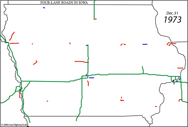
1973
- Unknown: US 20, 1st Street in Cedar Falls to southeast of Waterloo
Airport (part w/IA 57)
- Spring: US 30, full opening of Ames bypass
- August: I-29, Hamburg exit to Missouri (completes I-29)
- September: I-380, I-80 to Cedar Rapids Airport (#16)
- October: I-280, US 6 to Illinois
1974
- February: US 34, Central Avenue to Main Street (Burl)
- Unknown: IA 13, Central City to US 151
- May: US 34/275, I-29 to east junction US 275
- November: US 20, IA 187 to IA 38; I-74, US 67 to Illinois
1975
- Unknown: US 30, 6th Street SW to IA 13 (CR); US 65, I-80 to north side
of Bondurant; IA 141, Granger to I-35/80
- June: US 34, US 61 to Central Avenue (Burl)
- September: US 30, US 61 [old IA 956] to Z24
- November: US 30 and US 61, De Witt bypass; I-35, IA 106 to US 20 [D28]
(#144) (completes I-35)
- December: I-380, 5th Avenue SW to 33rd Avenue SW
1976
- June: I-380, 33rd Avenue SW to Cedar Rapids Airport; US 20, Webster
City to US 69
- November: US 34, West Burlington to US 61; all of I-129; US 20/IA 520,
South Dakota to Lakeport Street (SC)
1977
- Unknown: IA 141, IA 144 to US 169
- Fall: I-680, Nebraska to I-29 (completes I-680)
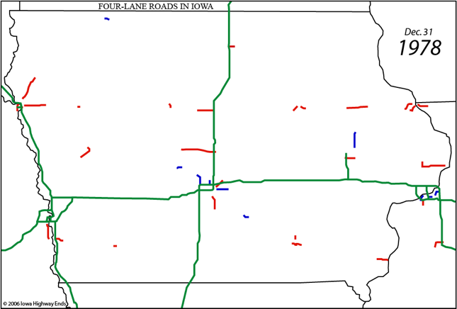
1978
- Unknown: US 63, one additional mile north of Ottumwa to IA 389
- November: IA 5/92, Knoxville bypass
1979
- June: I-380, 5th Avenue SW to 7th Street NE (CR); US 20, Sioux City
bypass
- July: US 20, IA 150 to IA 187
- October: US 20, IA 17 duplex
1980
- Only year since the mid-1950s in which NO new four-lane segments
opened in Iowa, until 2013
1981
- September: US 30/218, Stoney Point Road to 6th Street SW (CR)
- December: I-380, 7th Street NE to Glass Road/32nd Street (CR)
1982
- November: US 218, F62 to IA 22; I-380, Glass Road/32nd Street to
Boyson Road (CR)
- December: US 61, US 30 to I-80
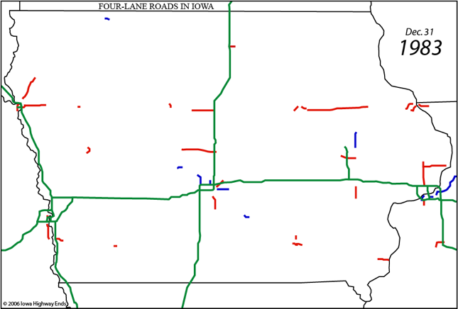
1983
- August: US 20, IA 297 [V49] to IA 150
- October: US 218, Riverside Drive to F62
1984
- Unknown: IA 28, IA 5 to Norwalk
- August: US 20/IA 520, IA 21 to IA 297; I-380, north end to east
junction US 20 and IA 150 to Boyson Road; US 218, Mitchell Avenue to
Shaulis Road (most w/I-380)
- December: US 20/IA 520, US 63 to IA 21; US 61, Muscatine bypass
1985
- June: US 218, I-80 to Riverside Drive
- September: I-380, east junction US 20 to IA 150 (completes I-380)
1986
- June: US 20, Black Hawk/Grundy county line to US 63
- September: US 30/218, 16th Street SW to Stoney Point Road
- November: IA 2, Nebraska to I-29
1987
- July: US 20, P59 to west junction IA 17
- November: US 20, IA 38 to Delaware/Dubuque county line
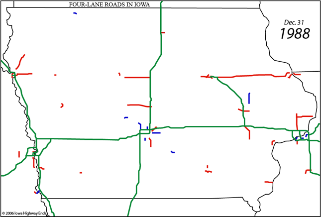
1988
- May: US 20, Delaware/Dubuque county line to IA 136
- June: US 20, Y21 to segment that opened in 1959
- November: US 20, IA 136 to Y21 (completes Waterloo-Dubuque)
1989
- October: US 218, IA 57 to Greenhill Road
1990
- November: US 169, Business US 20 to US 20 (which opened three weeks
later)
- December: US 20, US 169 to P59
- New interchange: I-74, 53rd Street (Davenport) (October 1)
1991
- Unknown: US 63, C66 to Black Hawk/Bremer county line
- January: US 52/61/151, 4th Street to Grandview Avenue (Dbq)
- October: US 20, I-35 to R77
- November: US 218, I-380 to US 63 (northbound only)
- December: US 61/151, 11th Street to Wisconsin (Dbq)
1992
- Unknown: US 30, R70 to Nevada; IA 163, IA 316 halfway to Prairie City
- Second half of year: US 30/218, IA 201 [W24] to Cedar Rapids bypass
- November: US 151, IA 13 to Springville; US 218, Greenhill Road to US
63 and southbound to I-380; US 71, Milford to US 18
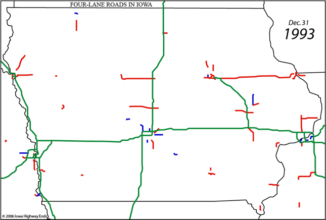
1993
- Unknown: IA 58, US 20 to University Avenue; US 61/218, duplex north of
Keokuk
- August: US 52/61/151: 4th Street to 11th Street (Dbq)
- October: US 34, Main Street to Illinois
- November: US 218, Waverly to C57
1994
- Unknown: US 61, Fort Madison to IA 16
- October: IA 163, Pella bypass
- November: US 63, Black Hawk/Bremer county line to IA 3 (Denver bypass
4 lanes by end of 1995)
- December: US 65, I-80 to IA 163
- New interchange: I-35/80, 86th Street (Urbandale); US 30,
Dayton Avenue (Ames) (August)
1995
- Unknown: US 151/IA 13, north junction to IA 100; US 218, IA 22 to G36;
IA 28, Grand Avenue to IA 5; IA 163, west of Prairie City
- July: US 218, C57 to IA 57/58; IA 58, University Avenue to US 218
- New interchange: I-80, US 65 bypass (Altoona)
1996
- Unknown: US 30, Marshalltown bypass; US 61, Blue Grass to I-280; IA
163, four-lane segments from Prairie City to Pella excluding bypasses
- August: US 61, Maquoketa to IA 136
- Fall: US 61, IA 136 to IA 956
- November: US 20, interchanges in Dubuque
1997
- July: US 63, Eddyville to IA 149
- August: US 61, US 34 to IA 16
- September: IA 163, IA 92 to US 63
- October: US 218, G36 to IA 92 and G52 to G62
- November: US 151/IA 13, IA 100 to Mount Vernon Road; IA 141, US 169 to
Granger; US 61, Dubuque Airport to Zwingle
- December: US 65, IA 163 to US 69; IA 5, US 65 duplex
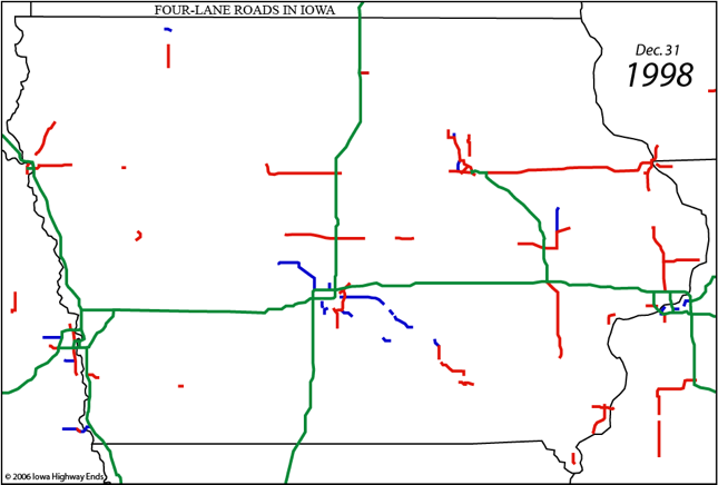
1998
- June: IA 163, G43 to IA 92
- August: US 63, IA 163 to Eddyville; US 218, IA 92 to G52
- September: IA 5, realignment around Des Moines Airport (bypassed
Jan/01)
- Fall: IA 163, Prairie City bypass
- October: US 30, Nevada to US 65
- December: US 218, Waverly bypass
1999
- Unknown: IA 5, US 65 to S23
- June: US 218, G62 to H28
- July: IA 163, bypasses of Monroe and Otley
- September: US 65, Bondurant to S27; IA 163, Pella to G43 (completes
Des Moines-Oskaloosa)
- October: US 61, Zwingle to Maquoketa (completes Dubuque-Davenport)
- November: US 30/218, US 218 to IA 201
- December: US 18, I-35 to Rudd (with new I-35 interchange)
2000
- May: US 151/IA 13, Mount Vernon Road to US 30; US 71, Milford to IA 9;
US 34, New London bypass
- July: US 20, R77 to US 65; US 30, US 151 to near Mount Vernon
- August: US 18/218, Charles City bypass; IA 28, Army Post Road to north
of Norwalk
- September: US 18, Rudd to Floyd; US 34, east of Mount Pleasant to
northwest of Danville
- October: IA 5/92, near IA 181 [S45] to Knoxville; US 18/218, Floyd to
north end of Charles City bypass; US 218, H28 to north end of Mount
Pleasant bypass
- November: US 20, IA 14 to Grundy/Black Hawk county line; US 61, IA 38
to Y36
2001
- January: IA 5, IA 28 to US 65/69
- May: US 61, Blue Grass bypass
- August: US 61, Fort Madison to US 218; US 151, Springville to near
Linn/Jones county line
- November: US 151, IA 1 to north of IA 64; US 75, Sioux City bypass
- December: US 218/IA 27, Mount Pleasant bypass (part); US 34, 1.5 miles
east of new 218
2002
- July: US 61, Louisa/Muscatine county line to south end of Muscatine
bypass; US 218/IA 27, Mount Pleasant bypass (rest)
- September: US 63, north junction US 18 to north end of New Hampton
bypass; US 151, Cascade bypass; IA 5, I-35 to SW 96th Court (DM)
- October: US 18/63, north junction US 18 to south end of Business 63;
IA 5, SW 96th Court to IA 28 (DM) (completes Des Moines beltway); IA
330, S62 to US 30
- November: US 218/IA 27, Plainfield bypass; US 18/63, south end of
Business 63 to south of IA 346; IA 330, US 65/IA 117 to S62; US 65, S27
to IA 117/330
- December: IA 5, S23 to near Pleasantville
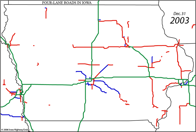
2003
- July: US 20, US 65 to IA 14 (completes Fort Dodge-Waterloo)
- September: US 218/IA 27, Nashua bypass; IA 5, Pleasantville bypass
- October: IA 5/92, 1 mile east of S45 (completes Des Moines-Knoxville);
US 151, Langworthy bypass
- November: US 218/IA 27, Nashua to Plainfield (completes north half of
Avenue of the Saints)
- New interchange: I-35, Mills Civic Parkway (West Des Moines)
(June 6)
2004
- February: US 218/IA 27, Donnellson bypass
- May: US 151, near IA 64 to south end of Langworthy bypass
- June: US 151, north end of Monticello bypass to south end of Cascade
bypass
- July: US 63, Eddyville bypass (completes DM/Oskaloosa-Ottumwa); US
151, Monticello bypass
- September: US 151, north end of Cascade bypass to Dubuque Airport
(completes Cedar Rapids-Dubuque); IA 60, Alton bypass
- December: IA 27, bridge to Missouri
2005
- May: US 34, Batavia bypass
- June: US 30, Le Grand bypass (was 2 lanes since Nov/04); US 218/IA 27,
south end of Mount Pleasant bypass to IA 16
- July: US 20, west junction Business US 20 to US 169
- August: US 34, Mount Pleasant bypass and near IA 16 to V63; IA 27, US
218 to near bridge
- November: US 34, Danville to West Burlington; US 30, 5 miles in Tama
County
- December: IA 60, Alton to Sioux/O'Brien county line
2006
- May: US 218/IA 27, IA 16 to IA 2 (completes south half Avenue of the
Saints)
- June: IA 60, 3 miles east of US 75 to Alton; IA 60, O'Brien/Osceola
county line to south side of Sibley; US 34, small piece near Danville
(completes Mount Pleasant-Burlington); US 34, east side of Fairfield to
beginning of Mount Pleasant bypass
- October: IA 60, Sheldon bypass; US 34, future US 63 split to Batavia,
including Agency bypass
- November: US 75, Le Mars bypass (completely finished June/07); IA 60,
between Sheldon and Ashton bypasses
- New interchange: US 20, Ansborough Avenue (November 8)
2007
- September: IA 60, IA 9 to 1 mile south of Minnesota line
- October: IA 60, rest of Sibley bypass
- November: US 63, Ottumwa bypass
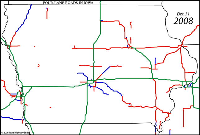
2008
- September: US 34, 3 miles in western Jefferson County
- October: IA 60, last segment into Minnesota with Bigelow bypass
(completes four-lane IA 60)
- November: US 34, Fairfield bypass (completes Des Moines-Burlington)
2009
- December: US 63, south of IA 346 to halfway between IA 188 and IA 93
2010
- November: US 30, US 63 to east of Tama; US 30, US 65 to State Center
- December: US 20, IA 4 to Moorland/west junction Business 20
2011
- July: US 30, State Center to IA 330
- August: US 30, Meskwaki (Mesquakie) casino to US 63 (realigned, two
lanes Nov/10) (completes Ogden-Tama)
- November: US 61, Fort Madison bypass
2012
- September: US 63, two segments in Bremer County between IA 3 and IA
188 (including IA 3 interchange)
- October: US 63, segment around C33 (completes Waterloo-New Hampton);
US 218, realigned four-lane at new Janesville interchange
- New interchange: I-35, NE 36th Street (Ankeny) (November 20)
2013
- Second year since 1957 that NO new four-lane segments opened in Iowa
2014
- October: US 34, I-29 to Nebraska
2015
- November: US 20, reconstructed segment through Correctionville
2016
- December: IA 100, Edgewood Road to Covington Road
- New interchange: I-80, Alice's Road/Grand Prairie Parkway
(WDM/Waukee) (December 1)
2017
- November: US 20, Correctionville to L25
- December: US 61, 2 miles south of Grandview to Louisa County line
2018
- September: US 20, L25 west to end of 1958 segment
- October: US 20, US 59 to US 71, and then Correctionville to US 59 (completes
four-lane 20 in Iowa!)
- December: IA 100, Covington Road to US 30 (completes IA 100)
- New interchange: I-35/80, 100th Street (October 15/November 7);
US 65/IA 330 (October 19)
2019
- November: US 30, Mount Vernon-Lisbon bypass
- Complete reconfiguration of I-80/380 interchange begins
- New interchange: I-380, Forevergreen Road (North Liberty)
(November 1)
- New interchange: IA 27/58, Viking Road (November 10)
2020
- August: US 52, Southwest Arterial
- Late August/September: US 30, around and including new US 218
interchange
- November: I-74, westbound (northbound) bridge
2021
- June: US 30, Tama to west of IA 21
- November: I-74, eastbound (southbound) bridge
- New interchange: US 20, Swiss Valley Road interchange
(reconfigures curve) (December)
2022
- November: US 30, section at IA 21 interchange but not interchange
itself
- November: US 18/218, eastbound half of Floyd interchange
2023
- June: US 61, north side Burlington to 210th Street
- August: US 30, through IA 21 exit
- New interchange: I-380, Tower Terrace Road (June)
- US 30, IA 21 to US 218
2024
(based on five-year plan)
2025
- US 61, Mediapolis bypass
- US 218, controlled access conversion north of Janesville
2026
- US 61, Mediapolis to IA 78
2027
2028
- IA 27/58, Greenhill Road interchange
- US 151, Springville interchange
- US 61, IA 78 to IA 92
Page created 2/20/06; last updated 8/31/23
To
Iowa
Highway Ends Annex
To Iowa
Highway Ends Index