
(July 1, 1920-November 11, 1926)
- In 1920, they knew it as: The North Iowa Pike, established no later than 1912, but later incorporated into the National Parks Pike (registered April 29, 1920) from Madison WI to Yellowstone National Park, and also Black Hills Highway (registered May 6, 1924) (12 counties)
- We know it as: US 18, except through Doon instead of Rock Valley
- Let's get granular: "NIP" below refers to North Iowa Pike.
- Sioux County: US 18, A42, K42, US 18
- US 18 was not extended west of US 75 until the AASHO meeting on November 11, 1926, considered to be the official birthdate of the US highway system. Thus, IA 19 was in the 1926 system for about a month as a route from US 75 westward; signs were changed by the end of the year.
- Sheldon: L26, 9th Street (now broken at RRX), Washington Avenue, E 9th Street, Country Club Road
- Downtown Sheldon was bypassed in 1930.
- By the end of 1933, you could drive from Sheldon to Des Moines on paved roads via Garner.
- Sheldon to Dickens: US 18, M27, B24, 355th Street, B24
- NIP route in Sanborn: Main Street, 1st Street, Eastern Avenue
- NIP route in Hartley: M12, Maple Drive, Central Avenue, 1st Street, 8th Avenue E. Hartley renamed its streets sometime in the first half of the 20th century.
- O'Brien County had IA 19 paved by the end of 1922.
- Dickens: 3rd Street, East Street/South Drive (broken at railroad), S 1st Street, 360th Street
- I wouldn't be surprised if the 1920s route used Main and 1st streets instead of East.
- Dickens to Algona: US 18, old US 18 on Ruthven's south side, US 18, a crossing of the Des Moines River slightly south of present, US 18, 560th Street, 400th Street/210th Street, Broad and 4th streets in Whittemore, B40
- NIP in Ruthven: N20, Rolling Street, 358th Street, 355th Avenue, 355th Street, 370th Avenue
- Algona: B40/McGregor Street, Ridgely Street, State Street, Phillips Street, Diagonal Street, Commercial Street, Main Street, Locust Street, Johnson Street
- Algona to Britt: US 18, 200th Avenue (across RRX), Old US 18, Main and East streets in Wesley, US 18, Eden Avenue, 225th Street
- Britt: 2nd Street NE, 2nd Avenue NE, Diagonal Street (dead-ends at drainage ditch)
- Britt to Garner: US 18, with abandoned pavement between Ladd and Lake avenues and the frontage road at Duncan
- Garner: Vacated road in line with Cottonwood Drive west of US 69, Allen Avenue, 3rd Street, Grove Avenue, 2nd Street
- Some time after 1921, the route was moved from Cottonwood to use 3rd Street all the way through town. The railroad overpass wasn't built until 1933 or so.
- Garner to Ventura: 235th Street, Vail Avenue, 240th Street, R70, 250th Street, Lake Street
- Clear Lake: Shore Drive, 7th Avenue N, US 18, a road slightly closer to the airport
- The NIP used 1st Avenue N, 4th Street, Main Avenue and 8th Street, but since IA 19 had continuous pavement from Ventura to Floyd by the end of 1921, I'm sure the all-7th route was in place by then.
- Clear Lake renamed its streets at an unknown time.
- The south route of the NIP between Clear Lake and Mason City became IA 106.
- Mason City: IA 122 (westbound lanes west of Killdeer Avenue, then eastbound), Crescent Drive, 1st Street S, Connecticut Street, State Street, Maple Drive, IA 122, Iowa Avenue, 260th Street
- A "seedling mile" and bridge over Willow Creek between Lark and Eisenhower avenues was built in 1913; it was extended a few years later as part of Federal Aid Project No. 1 (see below).
- The quarter-circular parking lot for the car dealership at the southeast corner of IA 122 and S34 is based on a former drive-in theater.
- Nora Springs: West Drive, 1st Street SW, Hawkeye Avenue, B30/Congress Street, Rock Grove Drive (with abandoned RRX east of Cameo Road connecting to B30)
- The railroad underpass on West was built in 1921.
- Rudd: B30, 150th Street, T26, Chickasaw Street, 1st Street, Floyd Street near railroad
- The eastward continuation of Chickasaw was built in the 1940s.
- The present diagonal bypassing Rudd was proposed as early as 1934 but was not built until 1959.
- Rudd to Floyd: B30, US 18 (westbound lanes to Kirkwood Avenue, then eastbound)
- Floyd: Liberty Street, Washington Street, 1st Avenue, Packard Avenue
- Today's diagonal was built in 1932.
- Floyd to Charles City: Vacated road on north side of US 18/218 (southeast of cemetery), Jess Lane and vacated extension southward (west of present 218), Cedar View Drive (which grabs parts of two alignments), Cedar Crest Lane and vacated extension south to 195th Street
- Charles City: Business US 218, Main Street, Ferguson Street, Grand Avenue (100 feet!), 5th Avenue
- Before or in 1934, the downtown route moved to a bridge in line with St. Mary's Street (a block east of the current crossing at Brantingham Street) and 4th Avenue. I don't know when this change happened; the first route/NIP route went through the business district and past the school.
- Then it moved back to Brantingham in the late 1960s.
- Charles City to West Union: US 18, IA 24, Business US 63, US 18, W40, 220th Street, Lynx Road
- There are four alignments at the Cedar River, the only place the route changed in Chickasaw County until 2002. They are 200th Trail, one just south of present 18, an overpass built in 1936, and the present route.
- The NIP used X Avenue as the north-south mile; this probably changed in 1913. The dip to 220th was eliminated completely, in favor of present 18, in 1922.
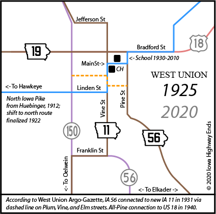
- West Union to Postville: Linden, Vine, Main, Pine, and Bradford streets; angled road northeast from the cut-off intersection with Easy Street; vacated road east and north from Echo Valley Speedway incorporating a farm driveway; US 18; Pine and Clinton streets on the south side of Clermont; US 18
- Postville to east junction US 52: US 18; 115th Street, plus Main and Burgess streets in Luana; Page, Center, Main, and Spruce streets in Monona; a somewhat jagged road from the Spruce/Water street intersection southward; Fox Avenue, US 18/52, Froelich Road and curve dipping south of present alignment, US 18/52
- Between Monona and Postville the pre-1926 route crossed the Chicago, Milwaukee & St. Paul Railroad (later the CMSP & Pacific) eight times; today there is only a crossing in Monona and an underpass west of Luana.
- East junction US 52 to McGregor: US 18 with Giard Road, 148th Street, the parking lot of Maggie’s Diner, and 145th Street; then IA 76/Business US 18
- Related routes:
- About 2 miles of IA 24 (II), north side of New Hampton, when US 18 moved to four-lane in 2002
- Part of IA 76 (II), through McGregor, when 18 was rerouted in 1989
- IA 26 (I), spur to Rock Valley that 18 would replace in 1930
- IA 35 (II), later IA 409, spur to Garner created when 18 was rerouted in 1952
- IA 102, spur to Hawkeye created when the newly designated IA 19 didn't go through
- IA 122 (III), road between I-35 and Rudd created when 18 was four-laned in 1999
- IA 162 (II) (unsigned), from downtown Charles City southward, which 18 would replace in 2006
- IA 167, spur to Doon created when 18 was rerouted in 1930
- IA 170, spur to Everly created when 18 was rerouted in 1930
- IA 257, spur to Dickens created when 18 was rerouted in 1933
- IA 424 (I), spur to Britt created when 18 was rerouted in 1961
- IA 946 (I), unsigned old US 18/52 between Luana and Monona
- IA 992 and 993, unsigned old 18 from west of Wesley to Britt
WEST End: South Dakota state line (Big Sioux River), Lyon County IA/Lincoln County SD
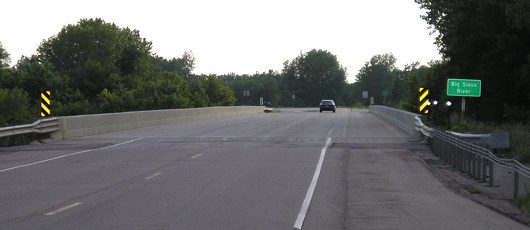
Facing west on 18
Although the Registered Highway Routes map shows a dip to Beloit, there was a bridge at US 18's current location in the 1920s.
Along the route
Canton,
S.D. As you enter Canton from the east you see at your right
... the National Indian Insane Hospital ... . As you journey nearer
town, you see at your right, the Augustana College, a beautiful $75,000
structure with a three story dormitory. This institution is governed by
some of the foremost educators in the state, and as you pass through the
city you will notice the three large public school buildings which are
up-to-date in every respect, steam heated, electric lights, closets,
etc., teaching the regular course with agricultural, domestic science,
manual training, gymnastics and other courses in addition to the regular
course.
— Huebinger's Map and Guide for North
Iowa Pike (1912)
Cerro Gordo County, Mason
City and Clear Lake came under the wire first of all Iowa communities,
in the completion and dedication Thursday, August 29th, of the first
surfaced highway to be built in Iowa as a connecting link between any
two cities. Not only is the road the first paved surface interurban
highway in the state but incidentally, it is Federal Aid Project No. 1,
being the first road in Iowa to be built under the present federal aid
law. Further, it is the first and only road so far in Iowa, to receive
state aid in its building.
— Iowa Highway Commission Service
Bulletin, September-October 1918
Facing northeast (probably 1923)
© Iowa Department of Transportation. All rights reserved.
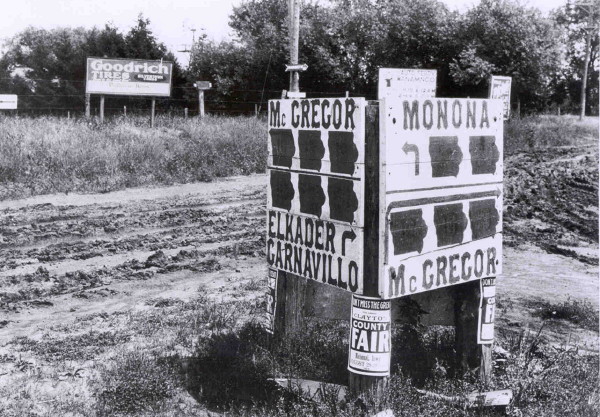
This, to my knowledge and surprise, is the only image I have found of 1920 system highways with their state-outline markers. (Newspapers of the time had extremely few to no local photos.) The relative location of this point is where the now-abandoned diagonal from IA 13 met US 18; the absolute location is just south of present 18 and just east of the FS station. You can't really see the numbers in there, but top left would be 10, 13, 19; bottom left, 10, 13, 20; top right, 19 and 20; bottom right, 10, 13, 19.
EAST End: Mississippi River (ferry landing), McGregor,
Clayton County IA/Crawford County WI
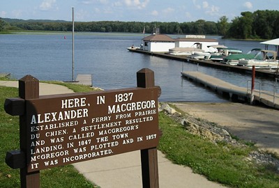
Facing east (9/7/06)
This is at the end of Main Street in McGregor, as the highway turns north toward Marquette and the bridge to Wisconsin. But until mid-1932, this is where you connected to Wisconsin, and thus IA 10 and IA 19 would have ended here, and IA 13 originally would have ended here.
Facing east (9/7/06)
Page created 5/30/20; last updated 5/1/22