
(July 1, 1920-August 9, 1927)
- In 1920, they knew it as: The I.O.A. Short Line, officially registered January 8, 1924, but existing for more than a decade before that (8 counties, then 7)
- We know it as: US 6, G43, and US 71 from Council Bluffs to Lyman, IA 92 from Lyman to Oskaloosa, IA 23/149 from Oskaloosa to Ottumwa
- Let's get granular:
- Council Bluffs: Broadway, Oak Street (now a pedestrian walkway), Pierce Street, McPherson Street, G60 (broken by the Council Bluffs Airport), US 6
- Oakland: Frank Kearney Road, Chautauqua Avenue, Oakland Avenue, Main Street and abandoned extension northeast
- Oakland to Lewis: US 6, 525th Street, Hitchcock Avenue, Newton Road, vacated diagonal through Iranistan Quarry, Nishna Valley Road
- Lewis: Webster, Main, and 1st streets
- Lewis to Lyman, 1920-21: G43, US 71
- Lewis to Lyman, 1921-24: US 6, US 71
- Those 6 or so miles through and east of Lewis carried FIVE primary route numbers: 24, 2, 92, 100 (five weeks!), and 414. See much more about this segment on the IA 100 (1920 Series) page.
- The reroute through Atlantic temporarily gave IA 24 its only concrete, a short segment from Atlantic to the present 6/71 junction (which today is on the edge of Atlantic).
- Everything listed above was lopped off in the Great Truncation.
- Lyman to Greenfield: Quincy Road, 700th Street, IA 92, 270th Street, N72, IA 92, Jordan Avenue, 240th Street
- If it originally went through Massena (730th Street, Rockport Road, 1st Street, Main Street), it didn't by the end of 1926.
- Greenfield: Mills Street Extension (and, for the first two years, the vacated line on the south side of Titan Machinery), Mills Street, unknown connection (Linn Street?), 1st Street, Public Square, Iowa Street, Orange Avenue
- Greenfield renamed its entire street system sometime after 1930: north-south streets increasing outward from the courthouse, and east-west streets alphabetically from the north side southward.
- Greenfield to Winterset: IA 92, with these stairsteps in western Madison County: 230th Street, Cottonwood Avenue, 225th Street, and vacated road running north to where 92 turns east again
- Winterset: Summit Street, John Wayne Drive, Court Avenue
- Winterset to Patterson: Norwood Avenue, IA 92, 206th Street, Quail Ridge Trail and vacated road to east marked by trees, Rustic Lane (across now-gone RRX), long and short driveways, IA 92, more angular now-gone road east of Settlers Lane, IA 92
- Patterson to Bevington: 8th, North, 7th, and Long streets; now-gone RRX just southeast of the IA 92/Long intersection; vacated road south of IA 92; now-gone RRX at Wildrose Avenue, then a vacated road along the section line east to the county line; Warren Avenue
- An alignment hugging the Chicago, Rock Island & Pacific Railroad wasn't built until 1926.
- Bevington to Martensdale: Warren Avenue/10th Avenue, Jesup Street (broken by I-35), 20th Avenue, Jersey Street, 30th Avenue, Inwood Street
- The route in Bevington of Linnane Drive, 2nd Street, and Grant Street (extension of 2nd on the Warren County side, now the south edge of the paved area at Kum & Go) was used from 1926-31.
- Martensdale: Iowa Avenue, vacated extension east meeting vacated extension of 40th Avenue across the Middle River
- Both the 1912 and 1914 county maps call Martensdale...Yaggy? Indeed it was at that time.
- Martensdale to Indianola: Either IA 92, 70th Avenue, Kennedy Street (with stairstep instead of angle), IA 92 or R45, Keokuk Street, 45th Avenue, Kennedy Street, IA 92
- Present 92 here, save for the angle near Kennedy, was on the I.O.A. Short Line in 1912, but state maps of the time show a deeper dip south of Martensdale before going east, and one early construction map marks IA 24 on R45. If it was the latter route, it was changed early on.
- Indianola: E Street (??), Salem Avenue, 4th Street (??)
- A note in my research indicates Salem, on the south side of the courthouse square, was used until late 1929. Paving plans for west of Indianola stop at E, and plans for east of Indianola start at 4th, so the 1929 project was likely between those two streets.
- Eastern Warren County: IA 92, 150th Avenue, Jewell Street, vacated road just north and south of present 92, 165th Avenue, Jesup Street, IA 92, vacated road across South River ending in driveway east of 200th Street, IA 92, Inwood Street, another short piece of vacated road ending in driveway, IA 92, S31, Indiana Street (through Beech) and vacated extension to just east of county line
- Pleasantville area: IA 92, G40 (but not as smooth), Columbus Street, 43rd Avenue, Inwood Street, old IA 5, vacated IA 5 right-of-way/northbound lanes to former north end of IA 181
- IA 5/92 split to Knoxville: IA 5/92, on and just south of the southbound lanes, but also with bits of 70th Avenue and Lucas Street, and vacated extension of Lucas east to 92nd Avenue
- Knoxville: McGregor Drive starting about 92nd Avenue (abandoned for a length), 118th Place, Pleasant Street, Roche Street, Main Street, Attica Road, McKimber Drive
- Much of this is Business IA 92 today.
- Knoxville to just east of Marion/Mahaska line: A much less straight alignment along old IA 92 involving 175th Place, Nevada Drive, abandoned road west of Breckinridge Cemetery, old 92, gravel cutoff southeastward, T25, Osceola Street, Ashland Avenue, the abandoned but still existing Bellefountain Bridge, and a vacated road heading northeast
- Now that the old IA 92 overpass at the railroad has been removed, the gravel road paralleling the railroad is in roughly the same spot as original IA 24.
- For more about this area, see the Business/Old IA 92 page.
- Mahaska County: Old IA 92, IA 92, Suffolk Road (broken by IA 163), High Avenue (broken by William Penn Mall), 11th Street, 267th Street, Osburn Avenue, 280th Street, Rutledge Avenue, 30th Street, IA 23, York Avenue, 320th Street, IA 23, IA 149
- Ottumwa (option 1): Court, Albany, Wapello, and 2nd streets, to end 2nd at Market
- Ottumwa (option 2): Court and 4th streets, to end 4th at Market
- Related routes:
- IA 2 (I), which replaced 24 in 1927 after creation of the US route system severely shortened 2
- IA 92, the direct living descendant of most of the route
- IA 100 (II) and IA 414, what the segment through Lewis became in 1958
- IA 176, stub to Cumberland created with IA 2 moved a mile south in 1930
- IA 254 (I), later IA 322 (II), the stub to Massena; only tangentially related since I'm not sure Main Street in Massena was ever part of the mainline
- IA 365, stub to Tracy created when IA 2 moved a mile north in 1932, bypassing the Bellefountain Bridge
- See also: Council Bluffs/Omaha Highway Chronology, Ottumwa Highway Chronology
WEST End (1): IA 8, now Broadway at Main St., Council Bluffs, Pottawattamie County
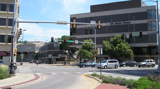
Facing north on Main (6/20/17)
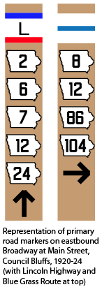
I think it's more likely that instead of ending when IA 24 met the Lincoln Highway, where much later IA 183 met US 6, 24 continued southwest to downtown Council Bluffs. After all, it's been piggybacking on IA 2 since the middle of Cass County, why stop now? In that case, Broadway from downtown northeastward carried five numbers — 2, 6, 7, 12, and 24 — until 12 and 24 were truncated. In the above picture, a right turn would start on 24.
WEST End (2): IA 18, now Quincy Road at US 71, Cass County
This is a mile north of where IA 92 meets US 71 today; the original route went through Cumberland. In 1921-24, 24 was rerouted to go all the way up to Atlantic and back down. This was part of a proposal from the Cass County supervisors to the IHC to switch IA 100 from a north-south road to an east-west one. This action inserted the supervisors into a road war, scared the townspeople of Lewis that they were going to lose access to a state primary, and three decades later set off a number swap that so mystified drivers that the IHC had to renumber a route after five weeks. Not bad for a 3-2 vote taken on January 5, 1921.
Along the route
On Nishna Valley Road between the Nishnabotna River and Lewis (4/15/09)
Statement
of significance
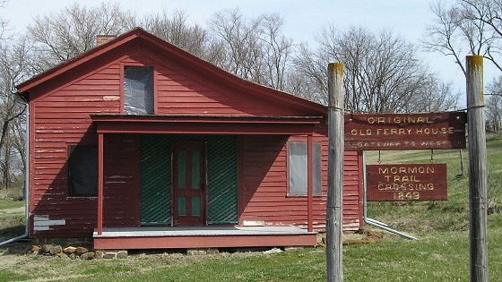
The Nishnabotna Ferry House ... was the home of Samuel Harlow Tefft who
operated the ferry at this crossing of this main transportation route
that crossed the East Nishnabotna River, This cable ferry was in
operation from 1857 to 1859. Originally, the State Road was an Indian
trail. The road and ferry were used by the western migration of
emigrants, stage coach and mail route, the Underground Railroad, a later
Mormon Trail, and the Mormon handcart companies.
— Nishnabotna Ferry House registration for the National Register of
Historic Places, 2000
Just across the river is the George Hitchcock House, built in 1956, recognized as an Iowa site on the Underground Railroad.
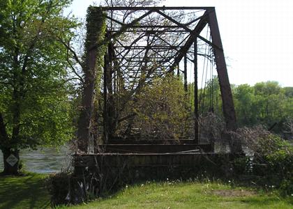
Bellefountain bridge east of Tracy, just east of the Marion/Mahaska county line (6/16/06)
EAST End (1): IA 8, now one of two locations, Ottumwa, Wapello County
Why wouldn't 24 have ended in Oskaloosa? Why the continuation? The IOA Short Line itself actually continued east, not southeast. I don't know why the redundancy with IA 13 existed until US 63 replaced them both in this corridor. If my Council Bluffs hypothesis above is correct, that means IA 24 started out connecting to IA 8 at both ends.
IA 24's end in Ottumwa depends on the timing of a change in both the Blue Grass Road and the north-south route. If, in 1920, the highways were following the Blue Grass map of 1912, IA 24 ended on southeastbound 2nd Street at Market Street. But if the routes were realigned before 1926, 24 ended on southeastbound 4th Street at Market, a block from the Wapello County Courthouse and at the doorstep of First Methodist Church.
Page created 5/2/20; last updated 5/1/22