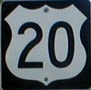
A four-lane 20
"ultimately
would extend straight west to Webster City"
-Waterloo Courier,
April 7,
1957
Unveiling of 20 shields on S56 southbound, north of
Steamboat Rock - approx. noon
The two photo catalogs linked below split the morning
into two groups: Before the ceremony and during/after the ceremony.
Some file names denote the speakers in the photo: Iowa
DOT director Mark Wandro, Gov. Tom Vilsack, Rep. Tom Latham, Rep.
Steve King, and Floyd Magnusson.
I arrived kind of late and ended up parking a block away from
the Steamboat Rock school. There probably hasn't been this many
cars in town in a long time. Buses from AGWSR, Eldora-New Providence,
Iowa Falls, and Alden waited to take the hundreds of people to
the ceremony. Many in the crowd were older; the vast majority
was in the 55-to-80 age range. The Steamboat Rock school has been
converted into a "mall" of sorts with different local
craftspeople in each room. The gymnasium, complete with old Steamboat
Rock Pirates drawing on the wall, had displays from local groups
related to either business or Highway 20 itself. Everyone got
a sticker that said "Highway 20 Across Iowa: Go Four It!"
as a reminder that 95 miles of 20 was still two lanes. A newsletter
which I declined to pick up at the time - and then cursed myself
because that booth was gone afterward - chronicled the history
of 20 and proposed four-lane routes through the Iowa Falls Times
Citizen.
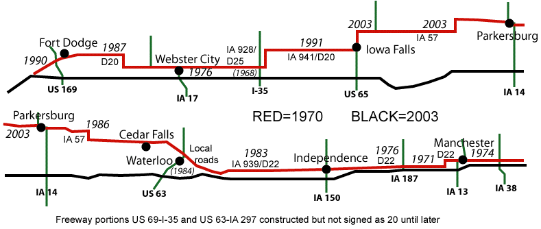
The official program gives these statistics for the new
segment:
26.9 miles long, a savings of 15.5 miles and 16.8 minutes (leaving
20 just barely over 300 miles in Iowa), four interchanges (actually
three - D35, S56 and T19 plus half-interchanges at 65 and 14),
and 80 million dollars. The bridge itself is 9.3 million pounds
of structural steel, 43.2 million pounds of concrete, 225 feet
from the bottom of the support to the top of the bridge, 1630
feet long, and 20.5 million dollars with 15 to 20 percent of that
directly attributed to environmental concerns and accessibility
challenges.
The buses headed west out of Steamboat Rock on D35, going to
the Owasa interchange (#175) and entering the freeway there. They
then traveled about three miles to the west side of the Iowa River
Bridge. The platform was at the west end of the eastbound lanes.
The bridge itself is between small mile markers 179.25 and 179.65.
At the east end of the bridge is the advance BGS for S56, which
listed Eldora and Ackley. However, the D35 interchange to the
west listed Eldora westbound. I don't know if that means the BGSs
for those interchanges in the other direction do not list Eldora
or if it's listed twice. The buses dropped us off and we had a
chance to walk along the bridge. Many, many fire trucks were already
parked on the bridge. The podium had a fake styrofoam 20 shield
on it. With something like this it shouldn't have been that hard
to spring for the real thing. :-P
After some remarks by Director Mark Wandro, Gov. Vilsack took
the stage. He said this freeway kept a promise to National Guard
troops that they would return to a better state than they left.
He talked about the economic importance of freeways: "A four-lane
highway means jobs." He said the job was not done, referring
to the rest of 20 west of Fort Dodge. (This was an oft-repeated
point.) He credited Iowa's congressional delegation for fighting
for Iowa's fair share of transportation funds, noting that because
of ethanol Iowa's share is less than that of other states. He
said this road would not be possible without the US 20 Corridor
Association and thanked them for their work. Finally, in a statement
directly mainly at the AGWSR band, Vilsack asked them to consider
remaining in Iowa after graduation. "This work is not to
benefit them (older people), but you. ... Be proud of where you're
from."
Then came Rep. Latham, the only official not in suit and tie.
"I did get the memo that this was informal." That got
a big laugh. Latham represents Hardin County. In 2002 Grundy County
switched districts from Jim Nussle to Leonard Boswell, neither
of whom attended. The other representative in attendance, Steve
King, represents three of the counties that don't have a four-lane
20. He thanked former state Sen. Rod Halvorson for his efforts.
Again, talk about completing the rest of the route got a bunch
of applause. He said that this was the longest stretch of four-lane
highway opened in Iowa at one time since the interstates. I believe
this is correct; the new US 18 in Cerro Gordo and Floyd counties
on Dec. 16, 1999, was 24 miles. (Two separate sections of 20 totaling
26 miles opened in 1976, though.)
Finally, Floyd Magnusson, president of the US 20 Corridor
Association
and a member of the Webster County Board of Supervisors, took
the stage for a short time. He thanked everyone and really appreciated
the work that moved the opening up from the original Oct. 4 date,
to a week before 500 cars go from Fort Dodge to Iowa City. (Comment:
Yes, forget economic development, that's the real reason. They
all want to get to Hawkeye games faster. :-)
I had to wait for the second round of buses before returning,
which was done by crossing the bridge and going to the S56 interchange
(#181). I do not know where the 15-16 miles got lopped off in
the mile-marking scheme. And as you can see by the map above,
it's not really going to be that accurate anyway. After putting
my name down for a shirt (they were out of XLs when I got there),
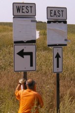
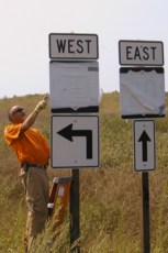
I headed north on S56 to what by evening would be "old 20".
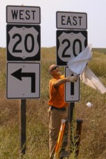
A stroke of luck put me back at the interchange just as they were
taking the covers off (see above). My first encounter with a new
57 shield was just west of S56 in Ackley. All of the 20 shields
had already been replaced, although the mile markers for 20 were
still up. I don't know when (if?) they'll get to fixing that.
However, no 57 shields were to be seen on northbound 65 approaching
57's new west end.
I got into Iowa Falls, where I planned to follow old 20,
formerly
IA 941, now D20, and return to Ames. (NOTE: As the LGSs at the
S56 interchange show, the official distance between Fort Dodge
and Waterloo is now 99 miles.) As I stopped at the Casey's on
65 to get a drink, the gas price was jacked up from $1.619 to
$1.689. Considering it was $1.499 when I got gas on Sunday night,
that hurts. Some stations in Ames were still at $1.589, but I
doubted that lasted much longer after I passed by.
Additional US 20 information - and pictures along its old
route
- can be found on IA
928, IA
941, IA
263, IA
57 west, IA
57 old east, IA
402, and IA
939.
Page created 8/22/03
To
Iowa Highway Ends Annex
To
Iowa Highway Ends Index