
(July 1, 1920-present)
- In 1920, they knew it as: The Imperial Highway, across the top of the state, except between Lake Mills and Riceville, registered January 4, 1918 (11 counties). West of Estherville, it was also the Des Moines, Fort Dodge, Spirit Lake, and Sioux Falls Highway.
- By the end of 1920, the Imperial between Lake Mills and St. Ansgar became IA 105.
- We know it as: IA 9, the only cross-state east-west route to keep its number to this day
- Let's get granular:
- State line to Lake Park: A10, Buchanan Avenue, 130th Street; Williams, Fell, and Broadway streets in Larchwood; IA 9; 1st Avenue E on the east side of Rock Rapids; IA 9, L26, A22, L58, IA 9, L62, 140th Street, M20, A18
- Huebinger's Map and Guide for Des Moines, Fort Dodge, Spirit Lake, & Sioux Falls Highway (1912) goes into downtown Sibley via 3rd Avenue, 9th Street, and L40/9th Avenue, but it's obvious even then that thru traffic could stay on Main Street.
- That guide and the 1912/1914 county maps use 160th Street between Sibley and Ocheyedan, but all the state maps and a 1921 construction document show the change had to happen in the 1910s.
- Lake Park (1920-24): Avenue B, then unknown roads on far east side
- Lake Park (1924-30): Avenue A, 7th Street, and Railroad Avenue (1924-30)
- The Huebinger Guide clearly marks the route on Avenue B through nearly all of Lake Park, but then draws in a connection on the far-east side that doesn't exist in/by the late 1930s. A 1924 construction document marks "present road" on B on the west side, and Railroad on the east. Given that Market Street between A and B is the business district, I think it most likely that first route was on B, Market, A, 7th, and Railroad, then moved to all-A in 1924.
- The portion of Avenue A west of 3rd Street rapidly fell out of favor and doesn't connect to B today.
- Lake Park to Spirit Lake: A18, 193rd Avenue, 145th Street, 195th Avenue, IA 9, 151st Street, 215th Avenue, 155th Street, IA 9, Hudson Avenue, 15th Street, Hill Avenue, Lake Street, US 71/IA 9, 250th Street, 252nd Street
- Multiple maps clearly mark IA 9 on a section of north-south Hill Avenue, although the section changed from between 15th and Lake to between Lake and 18th in 1930. The present route actually moved 9 closer to the Dickinson County Courthouse, because IA 4/US 71 running on Hill Avenue provided the primary route connection there.
- Even though it's a straight line, we've spent very little time on present IA 9 between the Little Rock corner and the east side of Spirit Lake! Just goes to show that straight lines took a back seat to connecting towns in the early system.
- Spirit Lake to Estherville: IA 9, A20, 350th Avenue, 155th Street, 360th Avenue, N25, A22
- In 1922, the Dickinson and Emmet county boards of supervisors proposed changing the route east of Superior to use 330th Avenue and A22. The IHC rejected this (Estherville Vindicator and Republican, January 25 and June 7).
- Estherville: IA 9, IA 4, 2nd Avenue S, S 10th Street, 3rd Avenue S
- 1st Street was for decades designated a cutoff route for IA 17 (future IA 4), a connection between points south and points west without having to deal with downtown and two railroad crossings.
- The "New Hotel" and "Rhodes Garage" in the Huebinger Guide remain buildings near the corner of Central and 7th today.
- Estherville renamed its east-west streets to numerical sequences north and south of IA 9 (which was renamed from Lincoln Street to Central Avenue) on June 10, 1938. (Estherville Vindicator and Republican, June 14)
- Armstrong area: IA 9, A22, IA 15, Diagonal Avenue, 570th Avenue, vacated eastward extension of 180th Street
- Emmet/Kossuth county line to Fertile: IA 9, R34 and 1st Avenue in Thompson, IA 9, 130th Avenue, 410th Street, 150th Avenue, A44, IA 9
- Between Swea City and Lakota, the Rock Island Railroad originally wasn't quite as straight and so there was some slight relocation of both road and railroad so they crossed only once.
- The 1912 and 1914 Kossuth County maps show the town of Germania, renamed Lakota amid anti-German sentiment in World War I. Kossuth County's German Township kept its name, while Hancock County's German Township was renamed Liberty.
- While the 1914 map does not show a road on the north side of Lakota, one most likely was added during the 1910s because no state map shows a deviation.
- Fertile to near I-35: Dogwood Avenue, 345th Street, Main Street, S18, IA 9, 350th Street (corner with roadside park), IA 9, 355th Street (6th Street in Hanlontown) (broken by I-35), Indigo Avenue
- Fertile was bypassed in 1925, but IA 86 (III) would not be created as a spur until 20 years later. Fertile almost certainly got its highway the same way so many towns did after about 1937: It cheated by withdrawing the city limits so it was no longer "on" the road going by the edge of town.
- Hanlontown was bypassed with paving in 1940.
- Near I-35 to IA 139: IA 9 with squared-off corners east of Riceville at Elm Avenue. There is no evidence of a different route in Cresco.
- IA 139 to Decorah: IA 9, 290th Street, 328th Avenue, vacated road south-southeast from the intersection of 328th Avenue and 285th Street, IA 9, 307th Avenue, County Street in Ridgeway, W14, 240th Street (and extension along section line to about 285th Avenue), IA 9
- Decorah: Industrial Lane (pre-2016 version), then Short, Mechanic, Water, and Montgomery streets
- Water Street, through Decorah's business district, was originally laid with brick in 1900. In 1947, Water Street was completely ripped up to put in new pavement. The opening of the street was so important to the city that the Decorah Journal on September 11, 1947, put together its biggest edition to date, with the second section dedicated to paving and history stories, and nearly every ad referenced the construction/opening in some way.
- Included in the paper was a full-page ad from the Fred Carlson Co., the Decorah-based longtime contractor for Iowa highway construction. Fred Carlson Co. was acquired in 2004 by Knife River and then sold again in 2008.
- Short Street retained state-highway-era pavement south of IA 9 for a long time. The street stub that met Short at Kerr Drive and ran behind the Fairfield Inn & Suites was how IA 20 originally changed direction, and then was how one got from northbound 52 to westbound 9. This stub was removed in 2016.
- Decorah to Lansing: IA 9, vacated arcing road on the north side of a farmstead northwest of W4B, abandoned arcing road (with still-existing pavement) on the south side of present 9 across Trout River, IA 9, Pole Line Road, A52, IA 9, Green Valley Road, A44/Iron Mine Drive, IA 9
- The Trout Run crossing, paved in 1932, replaced a more jagged route in the area. The relocated 1879 bowstring bridge in the park follows the 1928 grade. To the northeast is Freeport, an unincorporated village that now acts as Decorah's industrial park.
- Related routes:
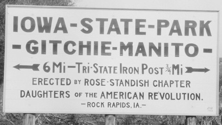
- IA 237, spur to Ocheyedan created from a part of 9 when it was straightened and paved in 1931
- IA 238, spur to Harris created from a part of 9 when it was straightened and paved in 1931
- IA 219, spur to Lake Park created when 9 was straightened and paved in 1931
- IA 86 (II), spur to Fertile created when 9 was straightened in 1945
- Segments of IA 9 left behind in cities' main streets: IA 276 (Hill Avenue in Sprit Lake), IA 15 (6th Street in Armstrong), IA 76 (Main Street in Waukon)
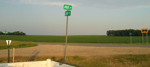
WEST End: South Dakota state line, now Buchanan Avenue at 100th St. and 268th St. at 487th Ave., Lyon County IA/Minnehaha County SD
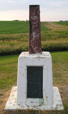
Original IA 9 met the Iowa-South Dakota state line about 3/4 mile west of the triple point with Minnesota, went 1/3 mile along the line, then turned north. This is east of Benclare United Methodist Church, the only structure left in that extinct map dot.
Facing north, but heading west, on 9 at the state line (Buchanan at 100th) (date unknown)
© Iowa Department of Transportation. All rights reserved.
Northwest quadrant of the state triple point (South Dakota) (6/25/06)
Pity this marker, for it has been through a lot and it shows. The plaque at the base says it was erected in 1859, removed in the early 1900s after vandalism, reset in 1938, broken by a vehicle in 1979, and "relocated at this site" in 1980. The states' names are stamped on the top part, but are hard to make out.
For more pictures related to the triple point see the IA 9 West page.
Facing southeast (6/25/06)
South Dakota's rural street system is a grid over the entire state, even though in the western part it gets awfully spotty simply because there are fewer roads. Iowa's north border is 168 miles south of the border with North Dakota (100th Street). The land South Dakota-Nebraska border is 304th Street. The conjunction of the Missouri and Big Sioux rivers, South Dakota's southernmost point, is aligned with 338th Street. The South Dakota-Minnesota border is 388 miles east of the South Dakota-Wyoming border (and 387 east of the South Dakota-Montana border, because there is a one-mile surveying error difference).
Along the route
Ocheyedan is a town of
about 800 population. It is located near the Indian mound from which it
derives its name. At this mound the Indians used to gather to mourn
their dead, the definition of the word Ocheyedan being "Where they
weep." The town is beautifully located in a fertile farming community in
Osceola county. It is one of the really good towns in Northwest Iowa,
and its markets for farm products are unexcelled. It is inhabited by a
wide-awake, thrifty class of people.
— Huebinger's Map and Guide for Des Moines, Fort Dodge, Spirit
Lake, and Sioux Falls Highway (1912)
The greatest incentive for
the establishment of the Des Moines, Fort Dodge, Spirit Lake, and Sioux
Falls Highway was to provide improved roads to Spirit Lake, the mecca of
Iowa tourists. To the automobilist the lake region of Iowa offers many
attractions and during the touring season thousands of automobiles
gather at Spirit Lake from all sections of the Middle West.
— Huebinger's Map and Guide for Des Moines, Fort Dodge, Spirit
Lake, and Sioux Falls Highway (1912)
We are coming to the
conclusion around here that main automobile highways are of no great
benefit to towns the size of Swea City, particularly where the highway
cuts through the middle of the town like No. 9 does in Swea City. ...
One Swea City official suggested the other evening that it may be
necessary in the future to deflect No. 9 a mile north so it will miss
the town. We laughed at Lakota when No. 9 missed her by half a mile. Now
it's Lakota's turn to haha.
— Swea City Herald editorial
reprinted in Iowa Highway Commission
Service Bulletin, April-May-June 1925
EAST End: Lansing, Allamakee County
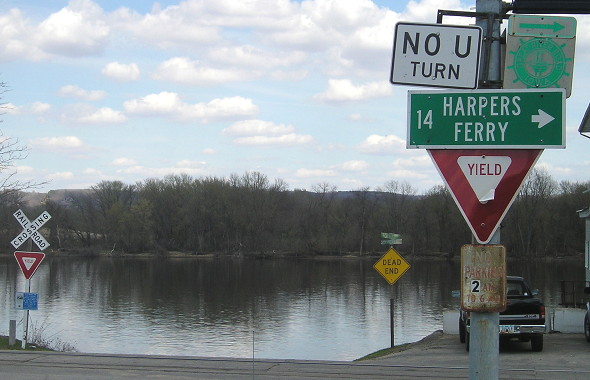
Facing east on Main Street (4/17/15)
Before the Black Hawk Bridge was built, the easternmost part of IA 9 was a looong spur from Waukon to Lansing. This is a block east of where IA 9 turn north today; X52 turns south and Front Street goes north under the very west end of the bridge.
Technically, since the IHC did not have control over roads inside cities in 1920, the east end was the city limits, but it's more fun to think of the route as going straight into the Mississippi River.
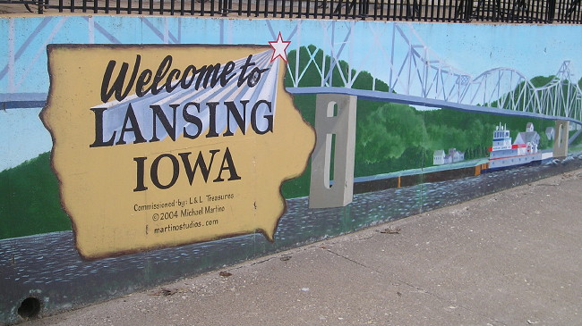
The thoughtful residents of Lansing welcome tourists with not just a mural, but a public restroom. (4/17/15)
For pictures of IA 9's end at the Black Hawk Bridge (1931-2024), see the Lansing page.
Page created 5/23/20; last updated 4/19/22