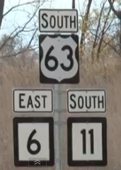
I am working on updating listings for the Clinched Highway Mapping website and found a news story from October from KTVO on the bypass of Kirksville, Missouri.
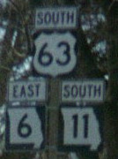
What made me do a double-take was one shot, below left, of the shields along the bypass. Missouri uses the state outline, as seen in the right picture, which I took along the old route in 2002.
Did MoDOT run out of blanks? Was this a contractor’s work? It’s such a little, yet glaringly obvious, error.
The 60-odd miles of 63 between Kirksville and Ottumwa is now the only two-lane segment between Des Moines and Jefferson City.


