Austin, Texas, Jan. 30 — I spent the entire morning at the George H.W. Bush Museum in College Station. I was glad I hadn’t tried to cram it in earlier. The museum is well put together, aside from the “Oval Office” that’s not even a mockup and them not allowing pictures there so as to try to get you to cough up $5 or $9 for one of theirs. Truman, Ford, and LBJ all do that part better.
Then I spent an additional hour looking around the athletic areas. The athletic center next to Kyle Field has Big 12 conference school flags with A&M flags in Nebraska and Colorado’s spots. Those will have to be replaced and new flagpoles added with A&M going to the SEC.
I finally headed out of Bryan at 1:45. I tried to get the GPS to follow a route that would keep me on US 190, but this was easier said than done. Adding to that, US 190 exits from itself twice in short order just east of I-35 (Spur 290 has two lanes, 190 one) and at I-35. At I-35, the exit is VERY poorly signed — take the exit to the frontage road far ahead, then go through lights at the volleyball interchange and turn left. The interchange isn’t a pure volleyball because of the frontage roads but it’s essentially the same concept.
Moderate traffic in the Killeen area, and then a complete morass in Copperas Cove, which is probably why they’re working on a bypass. West of there to Lampasas it’s four lanes with a center turning lane.

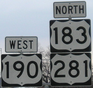
It’s not the highest US route multiplex sum, but it’s high up there.
I turned north just a bit to be on the 183/190/281 triplex, but construction and increasing clouds turned me south again after going through downtown. US 183 is four lanes undivided all the way to Austin. That center lane makes all the difference; 290 is marked as four lanes on the AAA map while 183 isn’t.
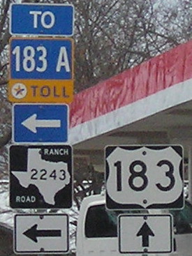
Both the layout of the road and the GPS tried to get me to take the tollway. There are a couple signs saying US 183 turns, but you have to be alert not to get onto “183A”. I think there used to be a way Texas could have signed the road as “Toll US 183,” but putting the US route on the free road is the right way to go. Hear that, Illinois?

No, I will not turn left. Stop recalculating.
The GPS wanted me to turn left to the toll road every time I passed an intersection that connected. I wish there was a way to input “Avoid toll road” or, more specific to this case, “I don’t want to go to that road and stop trying.” I think that’s out of the realm of current technology, though, and are why roadgeeks with maps are still important.
Once US 183 met the tollway/freeway again, it had to “merge onto itself” and this was mostly moderately signed. That’s when it steadily started to sprinkle. After crossing I-35, traffic started to slow near the Manor Road exit, where there are some high ramps being constructed. It was a crawl most of the rest of the way to the hotel near the airport. I turned the car in and saved $40 for not having it another 12 hours, plus I won’t have to worry about it in the morning.
With the five counties I added today, I almost closed the gap between I-35 and I-45, but not quite. Limestone County was just awkward to get to, and although it theoretically would have been doable, I got back to Austin just about the right time.

