Harrisburg, Illinois, May 23 — This just in: Illinois is tall. Really tall. I realized that once I started truly studying my planned route. Fortunately (for once!) I overpacked.
Route: I-57, I-74, US 45, US 150, to north cemetery in Danville, US 150, US 41, old US 40, US 40, IL 1, US 50, IL 33, old US 50 bridge, lost in Vincennes, Hart St to US 41, US 50, IL 130, IL 1, US 45 to Harrisburg
First, east to Danville on US 150. The GPS only squawked a couple of times trying to get me back to I-74. I stopped at Spring Hill Cemetery for digital pictures of the grave of Dennis Morrison, my great-great-grandfather, who served in the Civil War and marched to the sea with Sherman.

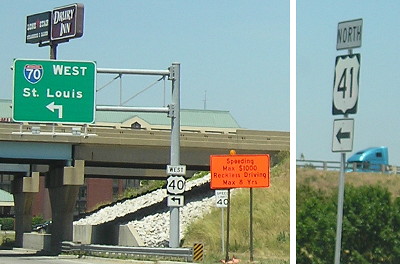
US 40 and 41 meet in Terre Haute, but at I-70 after a recent reroute off the National Road.
Then I followed US 150 all the way to Terre Haute, and looked to see the signage of US 40 moved to I-70. I got one photo with 40 and 41 shields both in the frame. I wanted to see the sports arenas of Indiana State, but found out that the football stadium was off-site. Since Indiana State is more known for basketball anyway, specifically the 1979 team with Larry Bird, the basketball arena was more fitting.

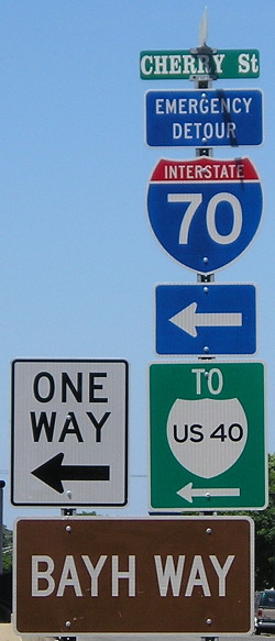
Sound it out. Get it? By-way? (Hulman Center. Note serif font on street sign.)
From Indiana State I went west and then southwest along the National Road, which is signed with special markers although I did not get pictures. It split off to stay just north of I-70 while the mainline road merged in, then crossed the state line. Then I followed I-40 off on the first exit. The National Road marker on the offramp simply said “Illinois (left) Indiana (right).”
Along the south side of the road was original BRICK National Road paving. It looked feasibly driveable, although each intersection seemed to have a for-sale vehicle parked on it.

Brick National Road with asphalt overlay, Clark County, Illinois (at 24-mile marker)
Old route through Marshall is signed as National Road but NOT Business 40.
My original plan of looping around Vincennes first and then going to the George Rogers Clark National Memorial wasn’t going to work. I exited at IL 33 instead, which is what the signs said to do anyway. The highway goes south to join old US 50 before heading north, but it’s signed east-west. I passed a surprising amount of businesses and a closed car dealership with 2011 stuff painted on the windows. As it was, I only had half an hour because I crossed the old US 50 bridge at 3:30 PM…Central.
What’s worse than museums that close at 5 PM? Museums that close at 5 PM a thousand feet on the wrong side of the time zone boundary. So the half-hour documentary was out, but I did get the audio inside the memorial about the paintings inside. Why can’t we make awesome monuments like this anymore? It really complements the bridge built about the same time.
 Old US 50 bridge as seen from George Rogers Clark National Memorial. Technically maintained as north end of IN 441.
Then my GPS got lost for the FIRST time during the day. I plugged in “Indiana Territorial Sites” even though I had asked for directions earlier. The GPS took me off that path and up former Business 41 before I gave up and turned around.
Then I arrived at the collection of buildings 15 minutes after closing. Fortunately, the guides were still there and offered a quick tour after I explained the GPS got me lost. Indiana’s territorial capitol, relocated here, is really small (PDF, p.1). The happy accident of the getting lost was seeing the site of the building that marked the Indiana-Illinois border: The border departs the Wabash River when it stays completely east of this point.
Despite my intentions to go back to Central Time, time was still short, and I saw the construction warnings for IN 441 so I went east to get US 41 and close the gap I had created on US 50 between there and IL 33.
West of Lawrenceville, US 50 is flanked by roads on two sides at times but always on the south side. The houses were along the south road, so I would say that’s the original. Were the existing lanes constructed as a plan to four-lane US 50 or even have it designated as an interstate? There is evidence that the state line once had a full-fledged welcome center. The old road also looked driveable, but at some points the patchwork between concrete and gravel was so mottled that I would want to do it in a pickup. Jim Gray has an in-depth study/photo gallery of old 50 in this area.
Following the old road out of the side of my eye provided distraction from the semi that I had to tail the entire way from IL 1 to just east of Olney — where it got through a one-lane-road setup for bridge construction and I didn’t. Both US 50 bridges over railroads in this area are having work done.
I drove into Olney for a break to re-evaluate my situation. It was getting kind of late, and hotel options were not going to be plentiful southward. Did I want to get stuck behind a semi going west, or stuck behind a semi going south, I asked myself rhetorically. I answered with another question: Did I really need those extra miles on US 50 and 45 given the circumstances and the fact I’ve already clinched Clay County? Southbound it was.
I plugged Harrisburg, the only place in southeast Illinois I knew had chain hotels, and it seemed a reasonable distance. But remember that rhetorical question? It turned out not to be rhetorical. About 55 of my first 66 miles back in Illinois were spent looking at the rear end of another semi.
I went through Grayville, where I had previously ducked into Edwards and Wabash counties in 2008, and decided I could keep going.
The entire landscape is different once you cross I-64. It’s hard to believe you’re still in Illinois. Trees, trees, trees! And I’m not even to the national forest part yet!
New-style McDonald’s, Hardee’s, and other outposts of civilization at Eldorado (IL 145), and then 45 spontaneously goes to four lanes.
Harrisburg is larger (almost 10,000) than its display on maps would have you believe, but too large for the GPS apparently. I set the Super 8 as the destination and it believed a) it and the Comfort Inn next door were the same address; and b) they were south of US 45 instead of north.
This trip covered my remainder of counties in eastern Illinois except Jasper, which is just off I-70.
