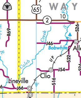
The segment of US 65 between IA 2 and Lineville on the 2012 Iowa Map for Bicyclists (PDF) doesn’t appear on the map at all. The map is color-coded with traffic counts — purple is the lowest, fewer than 700 vehicles a day — and shows trails across the state.
-
Recent Posts
Informational PDFs
- 2010 Iowa City Population Descending Order
- 2010 Iowa County Population Descending Order
- 2020 Iowa City Population Descending Order
- 2020 Iowa County Population Descending Order
- Iowa HS FB playoff brackets 2014
- Iowa HS FB playoff brackets 2015
- Iowa HS FB playoff brackets 2018
- School Directions Booklet FINAL
Key Posts
- College conferences and House apportionment
- How Iowa State has lost football games in the 21st century
- Iowa 2010 population breakdown
- Iowa daily newspaper publication, 2022
- Iowa school enrollment changes, 2001-15 (maps)
- Iowa's largest school enrollment gainers, 2001-15
- Kossuth County Area Schools and Rural Iowa's Population Collapse
- Post offices targeted for closure (1)
- Post offices targeted for closure (2)
Roadgeeking
Categories