This is a refresher on an old task of mine: Proofreading the official state highway map. I skipped two years partly because so many corrections had been made. The entire list is after the jump.
General (images below this list)
- Is the rest area near I-80 Exit 301 full-service or limited? The main map (fig. 1) and inset (fig. 2) show different things.
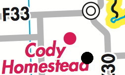
- The Cody Homestead dot (fig. 3) should be closer to the intersection of Z30 and F33. (Black dot shows more accurate location.)
- The village of Bentonsport (fig. 4) should be on the north shore of the Des Moines River, on or just east of where the paved road changes from going north-northeast to going east-southeast.
- Old Spur US 136 south of Wayland MO (fig. 5) has been decommissioned and should be a gray line. (The four-lane line in the area looks like it could use a tweak too.)
- IA 146 black line has not been extended from old 30 to interchange square (fig. 6)
- Is there a space after the first period in “Comm.Coll.” for Marshalltown CC?
- Smooth out “notches” in black lines that change direction for IA 14 at F27 (old IA 223) and IA 4 west of Rockwell City (old US 20).
 (2)
(2)  (3)
(3) 
 (5)
(5)  (6)
(6) 
Mileage modifications (see also note at end)
- US 30 mileage between US 63 and IA 21 (15) has not been divided up around new interchange east of Tama.
- Red US 218 mileage between IA 3 and IA 14 should be 31 (2+7+8+10+4) instead of 33
- IA 9 mileage between US 75 and IA 60 should just be red 23 now that old 60 has been turned over (remove black 22)
- Red US 63 mileage between IA 2 and US 34 should be 21 (1+18+2) instead of 20
Insets
- Clinton: IA/IL 136 line east of US 67 should be thicker
- Des Moines: “SE 68nd St” and “SE 32th Ave” on east side of map
- Iowa City: No destination for IA 1 heading out to the northeast, under the scale. I suggest “To Mt. Vernon”
- Iowa City: “Iowa’s First Capitol” for the building, to match change that was made years ago
- Omaha: “To Fremont” would be better option than “To US 6” for US 275 on the west edge
- Quad Cities: Does westward expansion of map past 60th Street make room for drawing in Scott/Muscatine county line up to F58 there?
- Quad Cities: The label for Coal Valley is right over a green patch that is (now) part of Moline
- Waterloo: Thick line for IA 281 ends at V43 instead of city limits
*On the mileages: Through the years, I have flagged places on the map where the “black” mileage — the distances between intersections and cities — did not match the “red” mileage — distances between two farther-away points, marked with stars. Looking at the big picture, there may have been cases where the black mileage was rounded but the red wasn’t. For example, 5½ and 2½ will be rounded to 6 and 3, respectively, but it’s only 8 miles while adding the digits would result in 9. That said, I think for simplicity purposes it’s better if the black digits add up to the red digit.
