At the end of May, when I made a sample map for a potential dissolution of the Clearfield school district in southwest Iowa, I said that my clean lines didn’t stand a chance for a variety of reasons.
I didn’t expect THIS. It’s a total maze. Mount Ayr (red) goes into Taylor County like river tributaries, while a long mile-wide finger of Lenox (yellow) pokes into Ringgold County southwest of Diagonal. Meanwhile, Diagonal (green) and Bedford (blue) gain little. (A reader comment at the Creston News Advertiser says Diagonal’s property taxes are “outrageous”, to support the school, and I can see that being the case.)
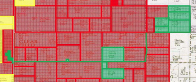
However, that map’s not quite the final product. The map that will be up for a vote in September has something unprecedented, or close to it, in Iowa history: A lengthy, narrow strip of land belonging to one school district but surrounded by another.

This is a clip of a detailed map. The green plots, and the line, are for the Diagonal school district. That entire strip goes south and west to encompass 4½ blocks of the town of Clearfield. It is the right-of-way for 170th Street (except that part that grows to encompass land of owner Jerry Ewalt) and 130th Avenue, then east on J23 to some parcels that are three miles away from the town of Diagonal.
Clearfield Superintendent Joe Drake told KMA (linked above), “It’s going to be really nice, because the way it’s written now, Diagonal, Lenox and Mount Ayr all have pickup points within the town of Clearfield, and they can just walk to their bus stop.” But there wouldn’t be a need for a Diagonal bus stop without that ridiculous connector — or if more land went to Diagonal.
Who knows, the point could be moot anyway by the end of the decade if Diagonal can’t make it. But on its face, this looks like one time that local control may have been too much of a good thing.
If the school building is not sold in the next year, Mount Ayr will take control, and will have one year to sell or else it will be demolished. It’s a fine building, but there are only so many things that could be done in times and places like this.
*A side note on Mount Ayr: While the school board district map (PDF) on the secretary of state’s website shows the district following the Ringgold-Decatur county line north of IA 2, a school employee told me there has been no change in the boundaries. That means there should still be a squiggle going northeast into Grand River.
