Fourth in a series.
In my previous posts regarding population, I cited the master’s thesis “Annexation in Iowa: an analysis of the Iowa annexation statutes” by Robin Renae Habeger (1997). That, along with some digging into more recent news, brings something to light: Extremely silly city limit lines aren’t just for Dallas County. (My campaign to name “Clive Town Center” the state oxymoron still stands, even if the concept doesn’t.)
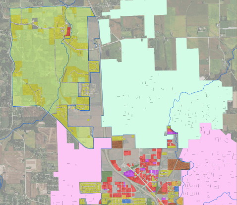
In the winter of 1996-97, an annexation struggle broke out. An area more or less bounded by Blairs Ferry Road, Milburn Road, Tower Terrace Road, and Miller Road got added to the city of Cedar Rapids. That combined with a Robins annexation nearly, but not quite, boxed Hiawatha in. The key was that Hiawatha was allowed an escape hatch around the land northwest of the intersection of Tower Terrace and Center Point roads. Here’s a map from the current Hiawatha Comprehensive Plan (large PDF stored on the city of Sioux City’s website).

The pink area is Cedar Rapids, while the seafoam green is Robins. The multicolored area at bottom center is Hiawatha, while the yellow-green-tinted area to the northwest is the area Hiawatha has planned for future annexation. The place where the pink crosses I-380 is the north half of what will become a Tower Terrace Road exit in 2022.
What about that strip between the tinted areas and I-380, you ask? Ah, here’s where it gets weird. In 2008 or 2009 — before the 2010 census, because of the lines the legislative districts use (PDF) — Hiawatha took that escape hatch and annexed land running along the west side of I-380. Then, in 2014, it went even further north (PDF), using the interstate’s right-of-way to skirt a development and annex more land up the side, clear past the County Home Road exit. Driving Center Point Road to Tower Terrace Road to Edgewood Road connects old Hiawatha to new, but not without passing through a bit of Cedar Rapids first.
That brings us back to that swath of yellow (developed) and green (undeveloped) land bounded by Tower Terrace Road, Feather Ridge Road, Midway Road, and the present strip of Hiawatha. Much of this is forested creek bottom. But one major part of it is not, for that area of yellow touching that spot of red in the north is the unincorporated village of Toddville. There is no set timetable for changes — and I would argue that Hiawatha should annex the already-developed areas closer in first — but it means that at some point in the future, Hiawatha’s thinking about pulling Toddville in.
There’s one more spillover effect. Whatever’s intended for the lion’s share of that “future plans” area, and also the northern third or so of Robins, including everything along County Home Road, will go into the Alburnett school district. It’s really fun to be a Pirate when the booty comes to you.
