Part of a series.
An Eagle Scout project is not an individual endeavor. It requires leadership and delegation, coordination and compromise. Making a booklet of directions to area schools was going to take a lot of time — and I happened to have a computer lab of Power Macintosh 5400s at my disposal.
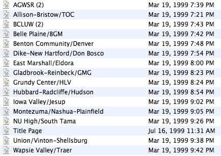
It’s the winter of 1998-99. We’re mailing letters out to schools, asking them to fill out a form with information about administrators, phone numbers, and just exactly how and where people should get to their buildings.
The information returned formed the core of the maps used to this day, with an assist from a pioneering Web service … MapQuest. Type in a location. Get a map centered there. Click to zoom in or out, click to load a new page to move over a “tile”. With that information, move on to the next step: ClarisWorks.
A history of the program from one of its creators can be found here. The program offers modules for word processing, drawing, painting, databases, and spreadsheets. The first two were key to this project. The drawing module was used to draw lines for streets and boxes representing the school, football field, etc. Those maps were then copied and pasted into the word processing module, where information about the school and written directions were kept.
Once the Scouts and parents participating in the project finished their page assignment, the file was double-checked. Then, at a Scout meeting, everyone went through a line, grabbed a printed page, and stapled the booklet together.

I. Save. Everything. (Except the original Traer quasquicentennial webpages. Sigh.)
After the project was done, I retained the files. In subsequent updates, they were converted to AppleWorks 5, then AppleWorks 6. Apple cared about AppleWorks enough that it was the first application to be “Carbonized” — that is, work in both Mac OS 9 and Mac OS X. The last version was released in 2003. It worked excellently, although I recall that after some map hiccups I decided I’d be better off doing the work on my iBook. Later, an AppleScript enabled me to create a single PDF that could be distributed online.
Then, in mid-2007, Apple unceremoniously wrote the program off. The program’s most important modules were split off into different applications, and not necessarily better ones either. Because of the legacy PowerPC code, Mac OS 10.6.8 is the last version that runs AW. The legacy of individual files, and the by-now awkwardness of the draw module, make re-alphabetizing with new schools a taller task than it otherwise could be. The Draw module, and thus the maps, cannot be duplicated through AW document translators.
In short, I’m working with files created in an application old enough to attend college whose format has been unsupported for six years. My modern map production methods are different, too. If I reverse my decision and continue doing this, I’ll need to seriously consider rebuilding it from the ground up.
